TOWN OF VIEW ROYAL COUNCIL REPORT: REZONING – 2951 CRAIGOWAN ROAD (CHRISTIE POINT) - JUNE 9 REPORT
The previous staff report from June 9, 2017, providing detailed context on the rezoning application, OCP policies, and technical analysis.
TOWN OF VIEW ROYAL COUNCIL REPORT
TO: Council
DATE: June 9, 2017
FROM: J. Davison, MCIP, Planner
MEETING DATE: June 13, 2017
FILE NO.: 3360-20-2016-05
REZONING – 2951 CRAIGOWAN ROAD (CHRISTIE POINT)
RECOMMENDATION
THAT first and second reading of Zoning Bylaw, 2014, No. 900, Amendment Bylaw No. 976, 2017 to rezone 2951 Craigowan Rd to CD-22 (Christie Point Residential) zone be made;
AND THAT a Public Hearing be scheduled for for June 27th, 2017 for Zoning Bylaw, 2014, No. 900, Amendment Bylaw No. 976, 2017.
CHIEF ADMINISTRATIVE OFFICER’S COMMENTS
I concur with the recommendation.
DIRECTOR OF DEVELOPMENT SERVICES’ COMMENTS
I concur with the recommendation.
DIRECTOR OF ENGINEERING’S COMMENTS
I concur with the recommendation.
DIRECTOR OF PROTECTIVE SERVICES’ COMMENTS
I concur with the recommendation.
PURPOSE OF REPORT
The purpose of this report is to present the application for the rezoning of the Christie Point property at 2951 Craigowan Rd and to introduce 1st and 2nd readings of Bylaw 976 to rezone the property to CD-22 (Christie Point Residential).
UPDATE FROM COMMITTEE OF THE WHOLE REPORT
This report is updated from the February 15 2017 Committee of the Whole report, to provide updated information where necessary and to address issues raised by members of the public, Christie Point residents, and Town of View Royal Council:
- The report has been shortened to focus on the key topics and things that have changed since COW; the entire COW report is attached to this report for a comprehensive review of all issues.
- The CD-22: Christie Point zone table has been finalized. It creates four sub-zones to limit heights of various buildings, and limits the top floor massing of buildings over 18m tall.
- Off-site infrastructure (primarily transportation/mobility) information has been provided in more detail.
- The applicant has proposed a reduction in the Community Amenity Contribution from $1 million to $750k, and increased the proposed private contribution to the residents.
- More detail has been provided with the timing and method of securing infrastructure requirements and amenity contributions.
BACKGROUND
Site Context
Christie Point is a 15.8-acre peninsula extending into Portage Inlet. The site is zoned RM-1: Ground-Oriented Multiple-Unit Residential within Zoning Bylaw No. 900, 2014. The zone permits a range of residential uses from detached residential to townhouse residential, at a maximum building height of 7.5m and a base density of 0.6 Floor Space Ratio (FSR).
The site is on Craigowan Road, which is accessed via Shoreline Drive, and in turn via Island Highway. An alternative transportation option exists in the E&N Rail Trail a short distance to the west. The site is close to Shoreline Middle School and detached residential properties along Shoreline Drive to the south.
161 market rental units are sited on the property in the following configurations:
- 103 2-bedroom apartment units (840 sq. ft.)
- 10 3-bedroom apartment units (1,020 sq. ft.)
- 48 3-bedroom townhouse units (1,135 sq. ft.)
There are no non-market units on the site.
The existing use and siting of the buildings are lawfully non-conforming to the existing zoning and to the general regulations contained within Zoning Bylaw No. 900, 2014 in the following ways:
- Apartment units are not permitted in the current RM-1 zoning.
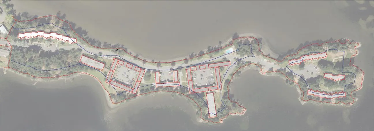
- Most of the buildings are partly within the 15m setback to the natural boundary to the sea (as per the below illustration with the existing building footprints in red and the setback in blue):
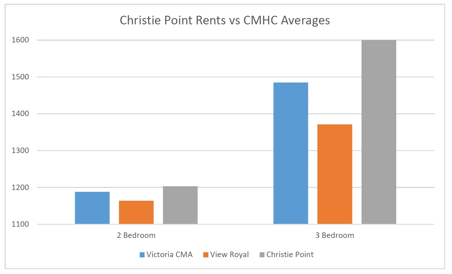
The units are rented at an average rental rate of $1,203 for a 2-bedroom unit, $1,425 for a 3-bedroom unit and $1,635 for a 3-bedroom townhouse (or a weighted average of $1,600 for all three-bedroom units). The applicant notes that the rents are above both the View Royal average and above the Victoria CMA average, as per the figure below:
There is a detailed breakdown of demographics and rent analysis attached to the report.
The buildings on the property are reaching the end of their serviceable use and the applicant wishes to redevelop the site.
Official Community Plan Context
The Town of View Royal Official Community Plan Bylaw No. 811, 2011 designates the site as M-R: Mixed Residential which is described as:
Small lot detached houses, townhouses and low-rise apartments up to 3 storeys and 1.25 FSR, and up to 4 storeys and 1.6 FSR for apartment dwellings.
The site is currently within three Development Permit (DP) Areas as described and regulated within the Town of View Royal Official Community Plan Bylaw No. 811, 2011.
Two DP Areas protect the natural environment:
- Sensitive Terrestrial Ecosystem (across the entire site)
- Natural Watercourse and Shoreline Areas (15m above and below the average high water mark or ‘natural boundary’)
One DP Area regulates the form and character of multi-family residential development, which includes building and landscaping design and materials:
- Mixed Residential Form and Character (across entire site)
PROJECT INFORMATION
The rezoning application proposes a development consisting of 473 townhouse and apartment rental units at a density of 1.15 FSR. This is consistent with the Mixed Residential Land Use Designation within the Official Community Plan (OCP). No OCP amendment is required as part of the application.
Density and Floor Space Ratio (FSR) Explained
In the most basic terms Floor Space Ratio (FSR) is an expression of density on a site. It is the ratio of the total lot area of a property to the total floor area on the property. ‘Floor Area’ and ‘Floor Space’ are both used and can be used interchangeably. Many jurisdictions refer to ‘FAR (Floor Area Ratio) which is the same thing as FSR. Lot Area and Floor Space are explained below.
The Zoning Bylaw defines FSR as such: “Floor Space Ratio (FSR)” means the ratio which the total floor space of all buildings on a lot bear in relation to the area of the lot on which the buildings are located. It may customarily be referred to as ‘Floor Area Ratio’ and for the purpose of this bylaw the definitions mean the same.
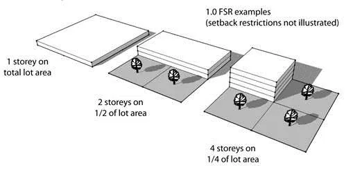
Zoning Bylaw No. 900, 2014 provides an illustration of the basic concept:
Lot Area
Lot area is the total surveyed area of a parcel of land. It does not take into account anything other than the lot area. It does not take into account any of the following:
- Setbacks
- Easements
- Rights-of-way
- Driveways
- Covenant areas
- Strata Common Property (for condo/multifamily developments)
- Area below the high water mark (if the property boundary does not match the high water mark or if there is a lake in the middle of the property)
- Any other instrument registered over the property, or affecting the property
In the case of Christie Point, the lot area is the entirety of the surveyed lot area. The 15 metre setback is included in the FSR calculation, as are the natural areas and the driveway. Furthermore, if the natural boundary does not appear to match the surveyed lot line, the surveyed lot line rules.
Floor Space
Floor Space is defined as such within the Zoning Bylaw:
“Floor Area” or “Floor Space” means the area of all basements, cellars, storeys, and half-storeys of all enclosed portions of all principal and accessory buildings on a lot as measured to the interior of the outside wall.
The Zoning Bylaw also describes areas within a building which are not included as floor space:
Floor space does not include:
- Any space or storage room located within the framing of the roof where the floor to ceiling or roof rafter height is not more than 1.5m throughout the entire space or storage room;
- Open spaces within a building that occur in association with lofts, stairways, vaulted ceilings, rooms or hallways that are open to above, or other similar open areas;
- Carports, elevator shafts, rooftop stairwells or rooftop enclosures for heating, ventilation or air conditioning equipment; or
- Underground or concealed parking.
Floor space within a half-storey is measured to the interior face of pony walls.
Official Community Plan and Height
A Land Use Designation within the Official Community Plan speaks to the use of a property, the density of a property (FSR) and the form and character of a property. While it is true that height in storeys is described in the Land Use Designations in Schedule L of the Official Community Plan, it is critical to note the statements in the Form and Character Development Permit guidelines regarding building height. For example, in the M-R (Mixed Residential) Land Use Designation’s Form and Character Guidelines ( the Christie Point Land Use Designation) it states:
Variances
i. Variances to building setbacks, building height, off site works, parking and landscaped requirements may be considered where it can be shown that the variance does not impact substantial compliance with the intent of the guidelines.
When discussed in relation to the consistency of the Zoning of a property to the Land Use Designation, the only two things that cannot be varied are use and density. This is why only use and density are considered when discussing consistency between the Zoning Bylaw and the Land Use Bylaw. All other regulations can be varied. When a zoning regulation such as height is varied, it does not require an Official Community Plan amendment. Only changes to use or density require OCP amendments.
Stories vs Height in Metres
The Zoning Bylaw does not describe the height of a storey. ‘Storey’ is described as such within the Zoning Bylaw:
“Storey” means the space between two floors or between any floor and the roof next above, but does not include a basement, cellar or crawl space.
As such, ‘storey’ is a poor measure of absolute height and building impact. Without a detailed measure of absolute building height (metres) a developer could conceivably build a four storey building with 15 foot ceilings on every storey and create a very high building, while meeting the four storey description in the Official Community Plan. This is why, in the Zoning Bylaw zone tables, metres are used to measure building height. Typically a storey can be described as 3m high as a rule of thumb, but it can often be more.
Proposed Uses
The proposed principal uses for the site are apartment residential and townhouse residential units. The proposal is for rental-only units, which will require a Housing Agreement bylaw to secure as a condition of the rezoning.
Proposed Density
The Mixed Residential land use designation within the Official Community Plan prescribes up to 1.25 FSR for townhouse use and up to 1.6 FSR for apartment use.
The proposed FSR for the site is 1.15, with no density bonusing. This is 30% below the maximum density possible on the site under the OCP designation. Staff recommends 1.15 FSR as the maximum density in the zone. Density bonusing is not recommended by staff as the proposed density accommodates the proposed development and no further density is requested or anticipated.
Setbacks from Lot Lines
As most the site is adjacent to the natural boundary to the sea, most of the site cannot be regulated by the setbacks within the zone. It is instead subject to the 15m special setback to the natural boundary to the sea, which cannot be changed by the rezoning process. The regulation is specified within Section 3.8.2.a of the Special Setbacks section of Zoning Bylaw No. 900, 2014:
3.8.2. No building, mobile home, recreational vehicle, or fence, retaining wall or other structure, nor any part thereof, can be constructed, moved, extended or located: a) within 15m from the natural boundary of the sea;
The 15m setback covers the same areas above the natural boundary as the Natural Watercourse and Shoreline Environmental Development Permit Area.
The proposed zone places a 15m setback over all property lines, to match the special setback and to define the setback for the southern property lines (which are not at the natural boundary). An expected variance at the Development Permit stage will be to the 15m setback to the natural boundary, as there are several places where the proposed buildings project into it. The existing buildings are, in some places, within the 15m setback requirement as they were built before that regulation was in place. The least impactful measure is to design the new buildings to be within the existing building footprints where possible. This will minimize the impact on trees and natural areas on the site.
Building Height
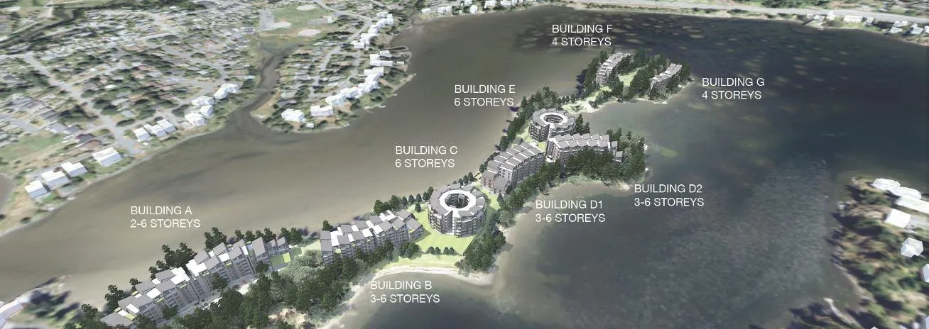
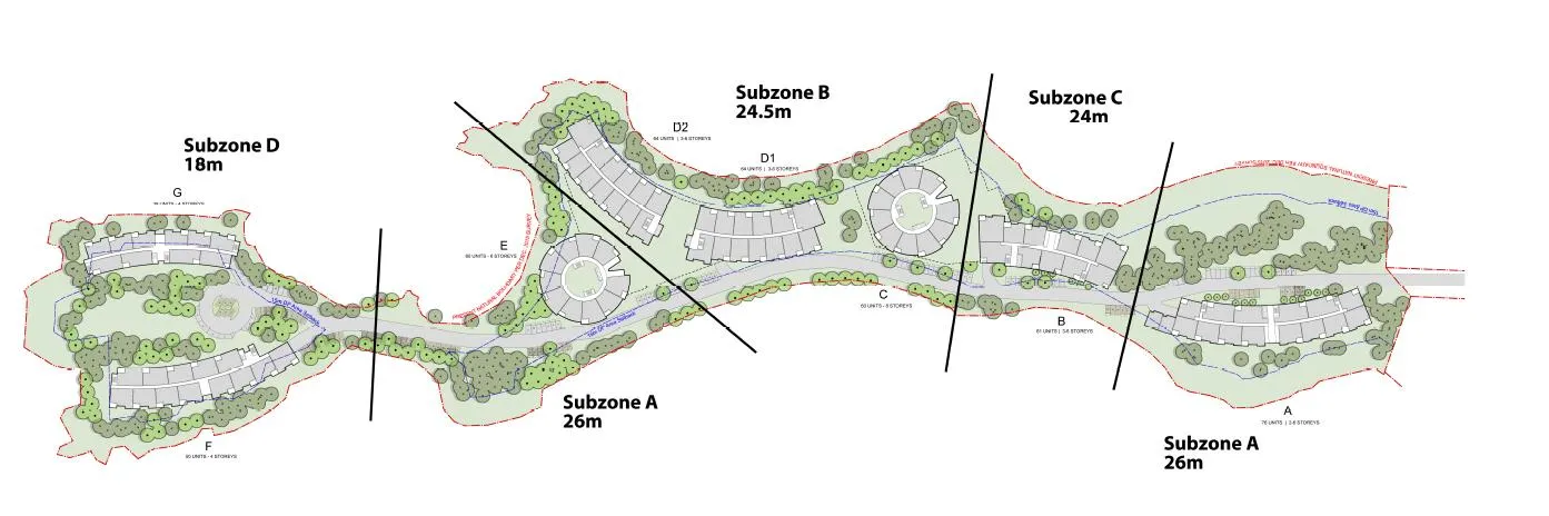
The proposed height of the buildings is 2 to 6 storeys in eight buildings as illustrated below. The height is expressed in metres in the zone table, currently calculated as a range between 18m and 26m.
The proposed CD-22: Christie Point Residential zone is parsed into four subzones to address different heights, as illustrated in the figure below (note that Subzone A has two areas):
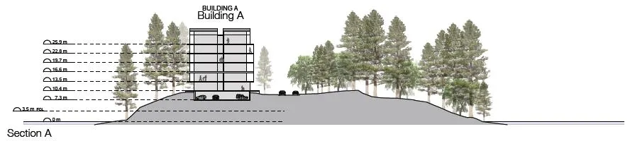
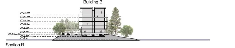
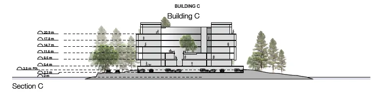
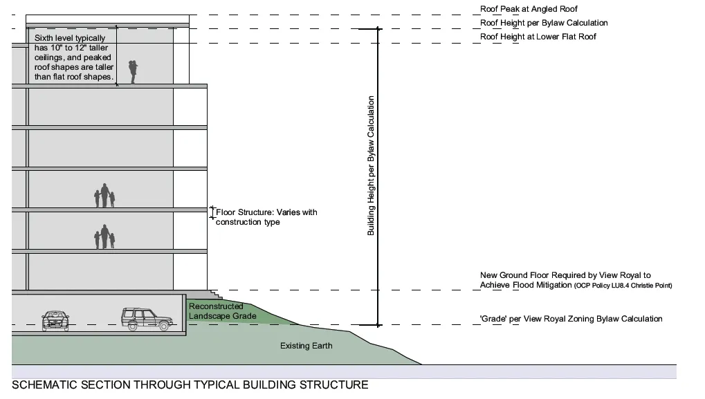
The height of a building is calculated from the average grade across a building footprint. The calculation of grade is defined within the Zoning Bylaw and is based on the lower of natural or finished grade at each significant point on a building. The applicant has provided cross-sections of the buildings as part of the application and illustrated below:
Increasing building height is the only way to add density on the site if most of the development utilizes the existing building footprints. The alternative to height would be more buildings which would increase the site coverage, and likely the removal of trees.
Building height is, in part, impacted by the demands of sea level rise and the necessary establishment of a minimum flood construction geodetic elevation of 3.5m as recommended by the geotechnical engineer’s report (attached). Staff recommends that the 3.5m elevation for habitable areas and 3m elevation for parkade entrances be established within the zone table.
Massing Visual Impact
A side-effect of building height is visual impact. The applicant has provided renderings to show how the development may appear from several vantage points:
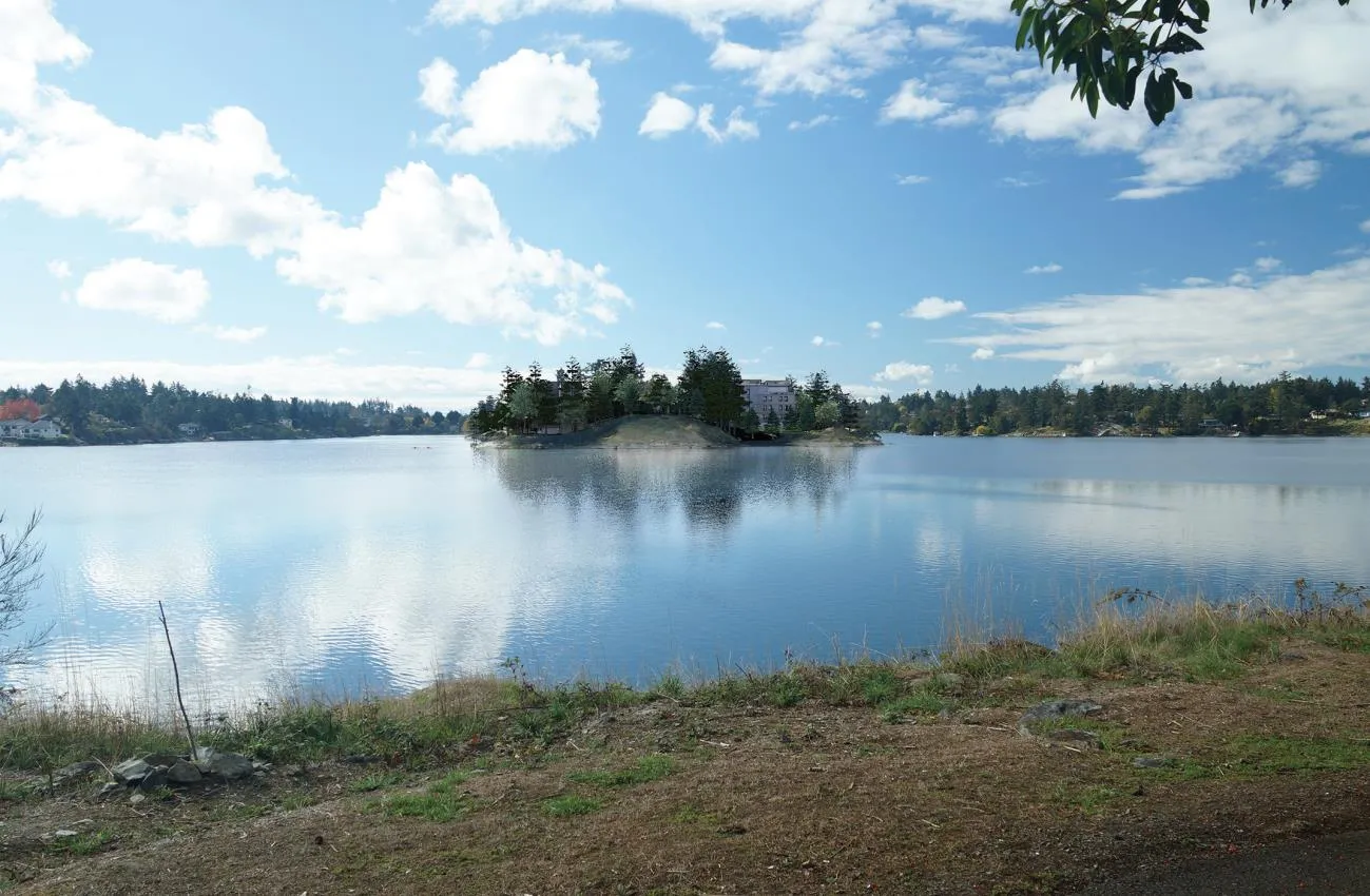
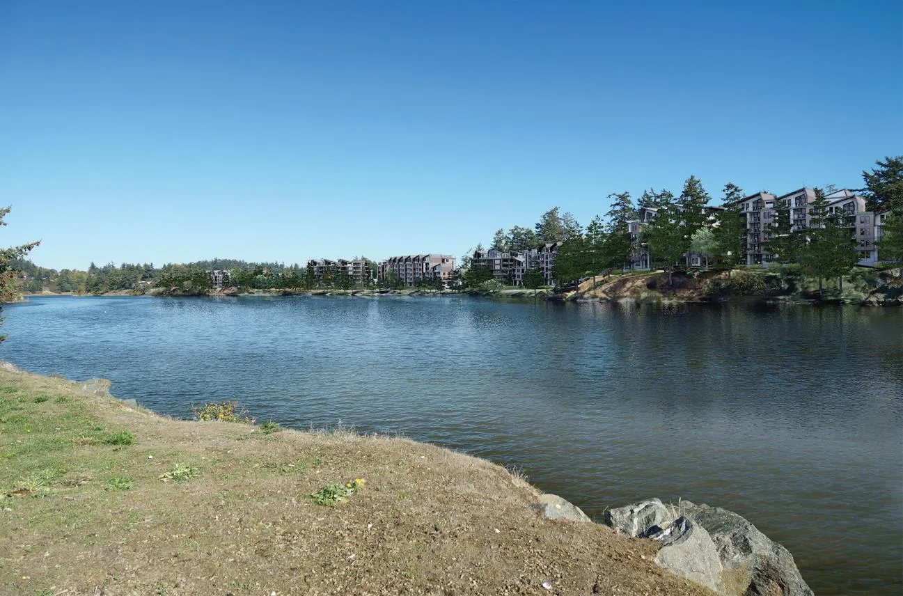
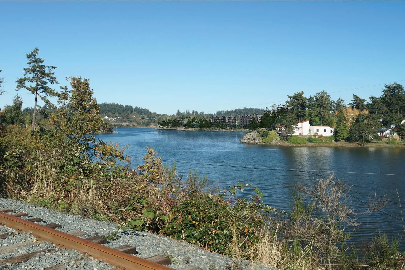
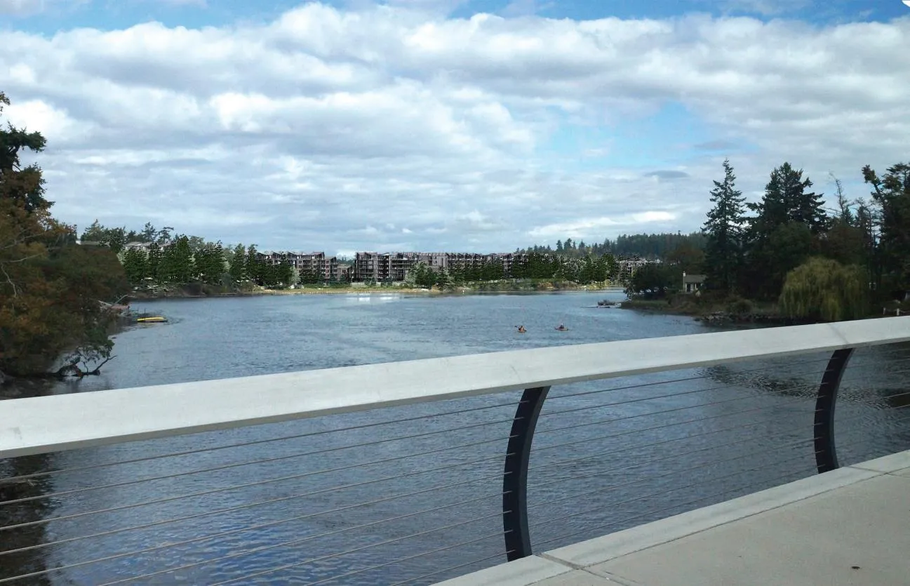
To address the concerns of Council and the public, the applicant has proposed to design the buildings with visual interest, step-backs, and articulation to remove some of the visual impact of the buildings.
In response to concerns from the Public and Council, the zone table has included a reduction in the floor area on the top floor (to 85% of the storey below) of the sub-zones A, B and C to ensure that there is a requirement for a reduction of visual impact in the top floor of the buildings. During the Development Permit for Form & Character there will be opportunity to further refine the massing of the buildings and to take into consideration the Mixed Residential Development Permit guidelines for building siting, height and massing:
GUIDELINES – SITING, HEIGHT AND MASSING i. Site design should respond to the topography and specific conditions of the site, and retain/work with existing grades and natural features such as rock outcroppings, mature trees and sensitive ecosystems such as Garry Oak meadow, riparian areas and shorelines. ii. Residential development should be oriented towards the street, except where natural features (slopes, rocks, vegetation) prevent this configuration. iii. Massing and siting of infill housing shall respect established neighbourhood patterns, including setbacks. iv. Create visual interest by providing variations in height, rooflines, massing. v. Attempt to maintain important public views to natural areas and scenic vistas through careful siting, building design and landscaping. vi. Building siting and placement of balconies, decks and windows should limit overlook and shadowing impacts on neighbours. vii. Buildings over two-storeys should utilize setbacks and/or terracing above the second level to reduce massing impacts on the street and surrounding neighbours, preserve view corridors and provide visual interest.
The following renderings show an example of the articulations:
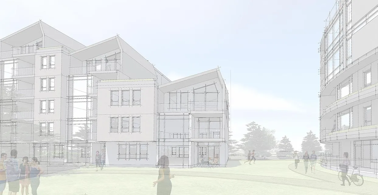
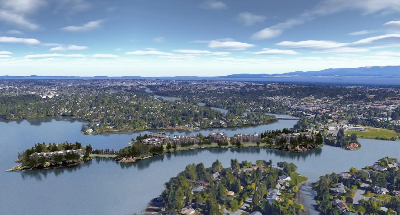
Visual impacts of the development could change in the future depending on several factors which can be determined at the Development Permit stage, including height and architectural style of the building, and tree planting or removal.
Existing and Proposed Site Coverage Comparison
| Existing | Area | Coverage |
|---|---|---|
| Surveyed Lot Area | 63,050m² | 100% |
| Paved Areas | 11,251m² | 17.8% |
| Building Footprints | 8,874m² | 14.2% |
| Landscaped Building Roof | 0m² | 0% |
| Natural and Landscaped Areas | 42,825m² | 68% |
| Proposed | ||
| Surveyed Lot Area | 63,050m² | 100% |
| Paved Areas | 7,507m² | 11.9% |
| Building Footprints | 17,234m² | 27.3% |
| Landscaped Building Roof | 3,735m² | 5.9% |
| Natural and Landscaped Areas (not including landscaped roofs) | 38,319m² | 60.8% |
| Natural and Landscaped Areas (including landscaped roofs) | 42,044m² | 66.7% |
Staff is proposing the following regulations to be included in the zone table:
Existing and Proposed Zoning
| Lot Size | RM-1 zone | Proposed CD zone |
|---|---|---|
| Lot size, minimum | 1,500m² | 63,050m² |
| Lot width, minimum | 18m | - |
| Lot Density | ||
| Floor Space Ratio, Base Density | 0.6 | 1.15 |
| Floor Space Ration with provision of 80% underground parking | Base +0.1 | - |
| Floor Space Ratio Bonus Density provision of 75% green roof | Base +0.1 | - |
| Lot Coverage, maximum | 40% | 35% |
| Impermeable Surface Coverage, maximum | 60% | 40% |
| Size of Principal Buildings and Other Structures | ||
| Building Height, maximum (Subzone A) | 7.5m | 26m |
| Building Height, maximum (Subzone B) | 7.5m | 24.5m |
| Building Height, maximum (Subzone C) | 7.5m | 24m |
| Building Height, maximum (Subzone D) | 7.5m | 18m |
| Building Width, minimum | 6m | 6m |
| Floor Plate Maximum | ||
| Top storey floor space (Subzones A, B, C) | - | 85% of floor space of storey immediately below |
| Siting of Principal Buildings and Other Structures | ||
| Front Lot Line Setback, minimum (proposed will be width of property) | 7.5m | 15m |
| Rear Lot Line Setback, minimum | 6.0m | - |
| Side Lot Line Setback, minimum | 1.5m | - |
| Flanking Lot Line Setback, minimum | 4.5m | - |
| Siting of Accessory Buildings and Other Structures | ||
| Siting of accessory buildings and structures | 1.2m | 15m |
| Minimum Flood Construction Level | ||
| Minimum geodetic elevation of habitable areas | - | 3.5m |
| Minimum geodetic elevation of parkade entrances | - | 3.0m |
The proposed sub-zones are positioned as such:
Parking Requirements
The zoning bylaw requires commercial and multi-family residential development that requires more than 100 parking spaces to include an electric vehicle charging station in a location that is accessible to residents. The location will be determined at time of development permit.
Sea Level Rise and Geotechnical Analysis
The applicant has engaged Ryzuk Geotechnical Engineering and has established that all factors associated with sea level rise over the anticipated lifespan of the buildings at 75 years result in a minimum flood construction level (FCL) at a 3.5m geodetic elevation. All habitable floor areas must be above this level. Staff is recommending that this figure be included in the zone table in the proposed zone. Flood-protected parking construction is also proposed, with all entrances to parking areas above 3m elevation.
The Ryzuk Geotechnical report considers all geotechnical engineering issues on-site, and has made recommendations for site development. There are no significant geotechnical issues of concern relating to the feasibility of the rezoning of the property and the current proposal.
Arborists’ Report and Tree Retention
The applicant has submitted an arborists’ report by Talbot Mackenzie and Associates outlining tree conditions and retention potential. There is also a supplied landscape master plan produced by Talbot and Mackenzie, Swell Environmental and LADR Landscape Architects which illustrates, among other landscape details, the tree retention, tree removal and tree planting proposal for the site. By keeping to the existing building footprints, the applicant has indicated that approximately 18 trees may be removed. However, the planting plan for the site suggests that +/- 500 trees will be planted on the site. These details will be further refined at time of Development Permit.
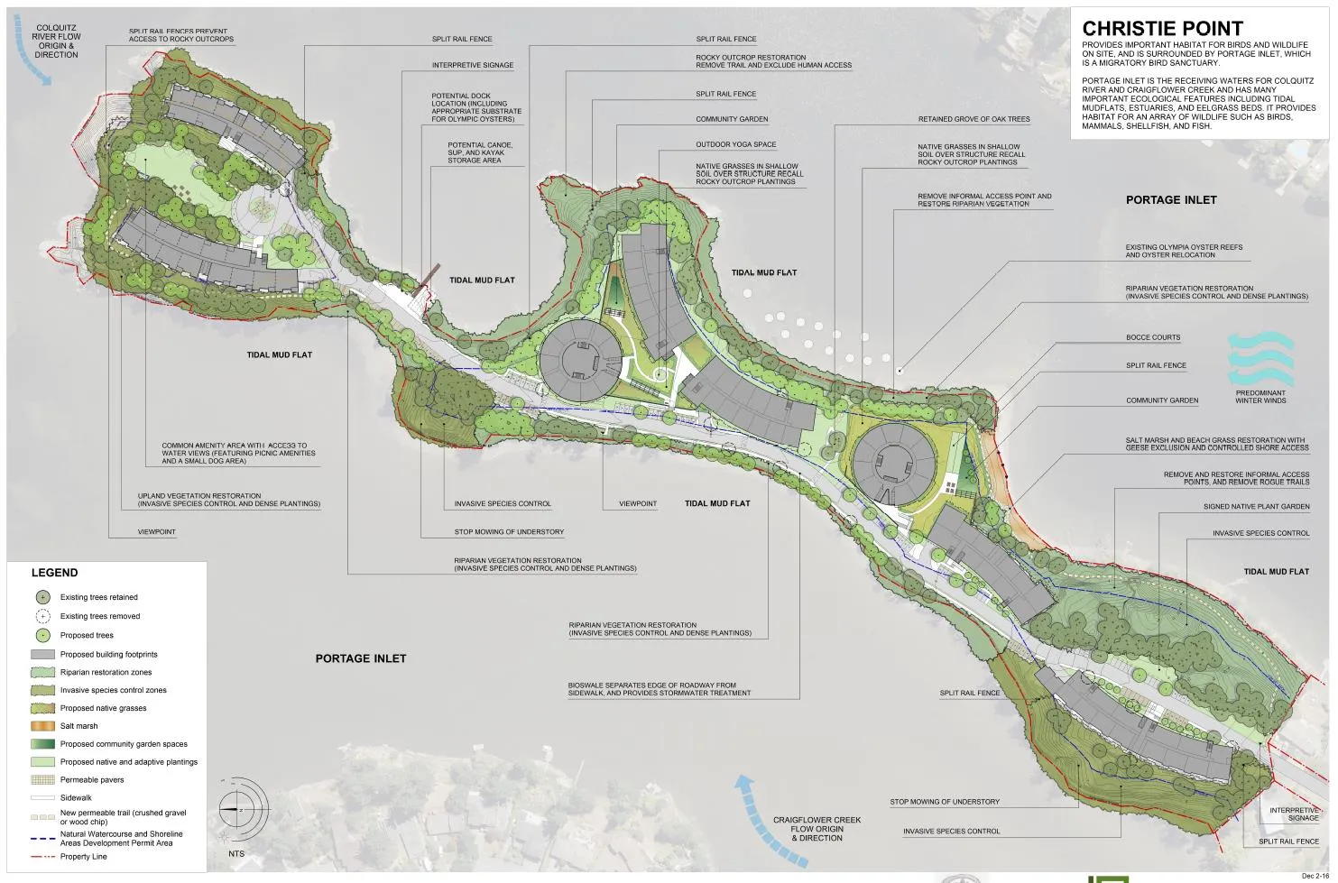
The proposal is for the construction of the roadway and proposed buildings within the existing roadway and building footprints where possible. This will minimize the impact on the existing trees. There is also a significant proposed native tree planting program such that the total number of trees on the property will be significantly higher than now.
A detailed summary of the trees is made by the report, including:
- survey number
- diameter
- species
- critical root zone
- size
- health
- condition of structure
- remarks and recommendations
It concludes that “there will be little additional impact on the native trees and treed areas that surround the site.”
Transportation
The applicant submitted a Transportation Impact Assessment by Bunt & Associates as part of the rezoning application. Staff has engaged Opus International Consultants to review the Bunt & Associates report for the benefit of a second opinion. The process involved several iterations; attached is the Opus opinion on the impact as well as the proposed solutions from Bunt.
The traffic volumes on Shoreline Drive will increase enough for the current designation of a local road (approx. 1,000 trips per day) to be changed to a minor collector designation (greater than 1,500 vehicles per day). Several transportation issues are addressed in the Bunt report as a result of the increased traffic. It should be noted that parking will not be addressed in this report.
Pedestrians
Pedestrian requirements leading from the development to Island Highway were reviewed by Bunt and Opus. Both traffic consultants agreed that a second sidewalk along Shoreline Drive east side was not required as pedestrian volumes did not require the additional sidewalk, and it was felt that mode share choice would not increase if the second sidewalk was added. However, the developer has agreed to extend the sidewalk approximately 120 metres on the west side of Shoreline Drive, from the existing sidewalk just north of the school to the development.
Staff requested pedestrian street lighting on the west side from the development to Island Highway and the developer has agreed to install the lighting to Town of View Royal’s specifications and standards along the west side of Shoreline Drive from the development to the Island Highway.
Both Opus and Bunt recommend that a crosswalk be installed across the Island Highway at Shoreline Drive, on the west leg of the intersection. The crosswalk will promote pedestrian crossing and will activate during the left turn movement of vehicles leaving Shoreline Drive, turning left onto the Island Highway. The addition of the crosswalk will also help to distribute pedestrian activity away from the Admirals/Island Highway intersection to assist in the performance of the intersection.
Advanced warning signals for the pedestrian crosswalk will be installed for the east bound vehicles travelling along the Island Highway.
Cycling
Staff requested that the existing gravel path connecting Shoreline Drive to the Island Highway running behind Shoreline School be upgraded to the same standard as the E&N Rail Trail. The upgraded multiuse trail will connect directly onto the Island Highway, crossing both the boulevard and the sidewalk. The connection will allow cyclists to travel a short distance on the Island Highway before connecting to the E&N Rail Trail. The developer has agreed to do this.
Bike lanes will be established in both directions on Shoreline Drive. Currently there is only a designated bike lane on the west side. The minimum width is suggested by Bunt to be 1.2 metres, while Opus is recommending a minimum width of 1.5 metres. Staff concurs with the Opus recommendation as the Town standards are at a minimum 1.6 metres. In addition, both Opus and Staff believe that bike lanes need to be installed on both sides of Shoreline Drive regardless of width constraints. The right of way currently has the width to allow for the dual bike lanes, although additional paving will likely have to occur on the east side of Shoreline drive to allow for the extra bike lane. This is contrary to Bunt’s perspective, on behalf of the Realstar Developments. Staff believes that bike lanes on both sides of Shoreline will help promote alternative mode choice.
Transit
Staff has had initial discussions with BC Transit concerning bus stop locations as well as the possibility that a stop be included on the Christie Point site. Initial thoughts by Transit were that a stop on the site would not work for logistical reasons. Once actual unit demographics have been determined, a follow up conversation with Transit will occur to confirm bus stop requirements.
Vehicles
Opus agrees with the Bunt conclusions that the increase in traffic from the Christie Point redevelopment (projected by Bunt to be 1.8% at the intersection of Island Highway/Craigflower Road/Admirals Road) will be negligible and a “relatively modest net impact will occur from a traffic capacity perspective compared to the current conditions…as existing traffic is causing the significant delays along the network in the afternoon peak hour.”
- There is concern with the grade of Shoreline Drive and the increase in traffic that outside of school hours traffic may tend to speed. As part on an initial traffic calming measure Bunt is recommending a narrow lane width for Shoreline of 3.2 metres. Staff concurs with Bunt’s recommendation.
- A traffic signal will be installed at the intersection of Shoreline Drive and Island Highway. As part of the installation, an advanced signal indicator (see attached graphic on page 2 of Opus report) will be installed to alert vehicles travelling in the eastbound direction. The light will be co-ordinated with the Admirals Road and Island Highway intersection so that the timing between the two intersections can be optimized.
- The Island Highway west bound lane will be constructed to a two lane cross section from the intersection at Shoreline Drive for a length of 120 metres, in addition, an approximate taper of 85 metres will be constructed. The result of the dual lanes will require the relocation of the existing bus stop approximately 180 metres west of the intersection.
The initial Opus report states that if the Christie Point redevelopment were to happen without improvements to the Shoreline/Island Highway intersection, the existing network would go from a current ‘fail’ to further failing regarding southbound traffic from Shoreline Drive to Island Highway, as drivers were only able to turn if westbound vehicles stopped to allow the turn.
Transportation Demand Management
Opus agrees with the incentives proposed by Bunt to reduce vehicle use and promote sustainable transportation alternatives. The traffic demand management initiatives will take two forms:
- The provision of alternate transportation infrastructure (pedestrian and bicycle)
- The reduction of vehicular traffic through ride-sharing, car-pooling and other initiatives
The proposed improvements to Shoreline Drive (bike lanes, sidewalk, lighting), to the Island Highway/Shoreline Drive (controlled intersection with a pedestrian crossing), and to the pathway through Shoreline school (to a regional pathway standard) will enhance alternate transportation choices for Christie Point residents, for Shoreline Drive residents, and for Shoreline School students and staff.
Benefits include:
- Better access to the E&N regional pathway for pedestrian and cyclists
- Better access to public transit for east and west-bound passengers along Island Highway
- Better access to potential future Admirals Road transit routes
- Better pedestrian and cyclist linkages to Admirals Road commercial areas
- Safer crossing of Shoreline Drive and Island Highway for pedestrians
Staff is securing off-site infrastructure improvements through a Development Agreement covenant.
Servicing Capacity
McElhanney Consulting Services has been engaged to provide a Conceptual Servicing Report as part of the application. The summary of required infrastructure upgrades is as such:
- Installation of new onsite sanitary sewer main.
- Installation of new sanitary manhole at the property line.
- Installation of new onsite domestic water main.
- Hydrant flow test to determine actual fire protection flows onsite.
- Additional hydrants to provide fire protection coverage within deficient areas of proposed buildings.
- Detailed investigation of the sanitary lift station.
- Additional topographic survey to fill in the voids of the existing survey, specifically the storm drain and sanitary sewer underground infrastructure and the sanitary lift station chamber.
- New road network and alignment to accommodate the proposed redevelopment buildings and integrated landscaping design to detain and treat storm water.
Community Amenity Contributions (CACs)
CACs are negotiated amenity contributions agreed to by the applicant/developer and local government as part of a rezoning process initiated by the applicant/developer. CACs can take several forms including the provision of amenities, affordable housing and/or financial contributions towards amenities. The agreed-to CAC is obtained by the local government, if the local government decides to adopt the rezoning.
The applicant had initially offered the following as a CAC:
- $1 million contribution to the CRD Regional Housing Trust Fund.
The applicant also offered to the residents the following assistance:
- Six months’ notification of relocation instead of the required two
- Payment of one month’s rent (as required by the BC RTA)
- A moving allowance or moving services through a contracted company
- Assistance with packing if the resident is prevented from doing so through disability
- Disconnection and reconnection of cable, internet and telephone
- Payment of mail forwarding for up to six months
- Give Christie Point Residents the first right of refusal for market-rate units in the new development
The attached letter from Heather Grey-Wolf of Realstar, dated May 30, 2017, outlines an updated, reduced community amenity contribution:
- $750,000 towards the Capital Regional District’s Regional Housing Trust Fund, an initiative of the Regional Housing Affordability Strategy.
In turn, the offer of assistance to residents has increased:
- Approximately $850,000 towards a resident relocation support:
- Providing residents with 12-months’ notice of the estimated date of the demolition, this is greater than the six months' notice originally proposed. During that period the two months’ notice required by the BC RTA will be provided.
- In addition to payment of one months’ rent required by the BC RTA, either providing a moving allowance of $1,000 or providing moving services (including providing packing supplies (boxes, tape)) through a company contracted by Realstar.
- In addition to the $1,000 moving allowance or moving services, for residents that have a physical disability and or a household with no able-bodied adults in the household, providing assistance with packing through a company contracted by Realstar.
- Compensating residents for the disconnection and reconnection of cable, internet, hydro and telephone services.
- Paying for mail forwarding through Canada Post for up to 12 months.
- Giving Christie Point residents first right of offer to rent apartments in the new development, at the new rental rates.
- Giving residents returning to the new development a rental rebate equivalent to two months’ free rent in the first year. This represents a 16% reduction in the rental rates for the year and is a new addition to the proposed Relocation Support Package.
Land Lift Analysis
The Town commissioned a Land Lift Analysis by Coriolis Consulting Corp, which is attached to this report. A Land Lift Analysis determines the ‘lift’ in land value as a result of the rezoning of the property, which is the difference in land value pre-and-post rezoning. This value is used to determine the Community Amenity Contribution (CAC) which is usually a percentage of the land lift.
The attached financial analysis assesses the proposed redevelopment’s financial ability to provide any community amenity contribution in the form of on-site amenities, cash-in-lieu, or some form of affordable housing. The analysis was completed on the basis of the project being rental townhouses and apartment, secured by a housing agreement, and at a density of 1.15:1 FSR.
The conclusion of the financial analysis is that the development, as proposed, does not generate a land lift that would support a major community contribution. It also notes that rental projects across BC, regardless of market, are typically are not able to support significant CACs.
In the case of the proposed project, one of the reasons behind its inability to support a significant amenity contribution comes down to what is referred to as ‘building efficiency’. Building efficiency is, in simple terms, the ratio of rentable to non-rentable space in a building – optimized rentable unit space vs space dedicated to corridors, servicing rooms, elevator shafts, etc.
The Land Lift Analysis report from Coriolis makes recommendations that are based on assumptions about buildings for which designs have not been finalized. The final building efficiency of the project could potentially be higher than stated in the report.
Securing Amenity Contributions, Off-site Infrastructure
Staff will secure the various contributions in the following ways:
Rental-only Status of Buildings
This will be secured through a Housing Agreement bylaw as a condition of the rezoning. The bylaw will be prepared if the bylaw receives first and second reading.
CRD Regional Housing Trust Fund Contribution
The contribution will be secured by a covenant, to be prepared and registered with the condition that no building permits are issued without the money being secured. It could be partially secured through partial building permit issuance (due to phasing etc).
Off-site Infrastructure
- Off-site infrastructure contributions will be secured through a development agreement covenant, to be completed in advance of issuance of occupancy.
- Paving a cycling connection to the E&N Rail Trail standard between Shoreline Drive and Island Highway
- Signalization of the intersection of Shoreline Drive and Island Highway
- Pedestrian Lighting on the west side of Shoreline Drive from the site to the Intersection of Island Highway.
- The construction of sidewalks, bike lanes and boulevards to Town of View Royal Collector Road Standard from the development site to the intersection of Shoreline Drive and Island Highway on the west side of Shoreline Drive.
- The installation of a bike lane on the east side of Shoreline Drive from the development site to the intersection of Shoreline Drive and Island Highway
- Creation of a new lane for 210 meters beyond the intersection of Island Highway and Shoreline Drive, including bike lane, boulevard, sidewalk and retaining walls
Other Items Required
After a successful rezoning, additional items will be required to enable development. These may include (but are not limited to):
- Three separate Development Permits to address Development Permit guidelines within the Town’s Official Community Plan
- A Servicing Agreement/Site Development Agreement
- Building Permits
- Soil deposit/removal permit (if required)
- Tree removal permits
ANALYSIS AND DISCUSSION
In considering the suitability of the site for the proposed rezoning, Council must weigh the potential drawbacks of the proposal against the benefits it will provide the Town and the region. The Town’s Official Community Plan contains policies which articulate the Town’s goals objectives and can be used to analyze the proposal at Christie Point from several perspectives.
OCP Policies
While there are many policies within the OCP that are relevant to the current development at the Development Permit Stage, the policies outlined here pertain primarily to the rezoning.
Policy LU8.4 Christie Point
Encourage any future redevelopment at Christie Point to include a mix of medium density residential and park uses. Development at this location should be carefully reviewed to ensure that environmentally sensitive areas are protected, potential sea-level rise issues are addressed, and safe and efficient road access from the Island Highway is maintained.
- This is the only Christie Point-specific policy within the OCP. The policy summarizes the major issues as outlined in the report, which are actively being considered.
Community-wide Objectives and Policies
Policy LU1.1 Neighbourhood Centres
Create a network of neighbourhood-serving, mixed-use centres. Encourage the majority of new and infill residential and commercial growth into these areas to create compact, walkable and cycling-friendly activity hubs.
- The site is close to the E&N Trail, promoting cycling
- Craigflower Elementary School and Shoreline Middle School are walkable from the site for such a use. Craigflower Elementary is a longer walk at about 1km from the entrance to Christie Point, which may be a deterrent for many students and parents.
- The Admirals commercial area is largely outside the distance of reasonable walkability for such services, though more ambitious residents may undertake it. This is especially true for the Admirals Walk area with a diversity of groceries, liquor, coffee, restaurants and services. At 1.1km from the entrance to Christie Point, a trip for groceries represents a 30-minute round trip walk, potentially carrying bags of groceries.
- The cycling linkage from Shoreline Dr to Admirals Walk is not optimal, with no bike lane along that section of Admirals Rd.
Policy LU1.2 Connected Centres
Ensure each neighbourhood centre is served and connected to the surrounding area by a range of transportation choices including transit, and bike and pedestrian pathways. Similarly, ensure that residential densities at neighbourhood centres increase the viability of transit, bike and pedestrian travel modes.
- The site is close to transit service on Island Highway, linking the downtown and the West Shore.
- Staff is actively reviewing the transportation impact study to determine how best to improve active transportation choices and accessibility from the site.
Policy LU1.4 Diversity of Forms and Uses
Support a variety of residential and commercial forms and uses to encourage socio-economic diversity, and provide for the diverse needs of youth, families and an aging population.
- The proposed purpose-built rental units in a variety of townhouse and apartment configurations will be a fairly unique housing product in View Royal.
- The choice of two-and-three-bedroom apartment units (as expected) provides family friendly options and aging-in-place opportunities. Single-level units are preferred for aging populations.
Policy LU1.6 Community Amenities
Foster the provision of community and neighbourhood amenities associated with new development through the development of amenity density bonus provision in the zoning bylaw or through negotiated Phased Development Agreements.
- There is no amenity density provision for the site.
- Any phased development would be for the benefit of the existing residents transitioning to new housing. Staff is actively working on assembling a comprehensive housing agreement and amenity contributions package.
Policy LU2.3 Targeted Residential Infill
On a case-by-case basis, allow limited residential infill in established residential areas as a means of providing greater housing options and addressing the demand for ground-oriented family housing. Infill should be designed to blend into the existing neighbourhood and should adhere to Infill Guidelines to be developed by the Town following the adoption of this plan.
- The applicant is proposing ground-oriented townhouses and apartment units where possible, many of which will be suitable as family housing.
- The development is intensifying the land use, and largely adhering to a similar pattern of development on the site.
Policy LU4.2 Support Walking, Cycling and Transit
Encourage higher density and mixed-use development at neighbourhood centres and along major transit corridors to promote walkability, cycling and transit use. Support higher residential density, commercial intensity and reduced parking requirements in areas well served by transit.
- The site is located near several transportation hubs, including Island Highway, Craigflower Rd, Admirals Rd, and the E&N Trail system.
- The site is served by bus linkages to downtown Victoria and to the West Shore.
- The Town is reviewing the supplied Traffic Impact Assessment to determine if the transit linkages are suitable enough to recommend the reduced parking ratios proposed.
Policy LU5.1 Conservation Designations
Maintain all protected natural areas through existing conservation and park designations, and the establishment and enforcement of Environmentally Sensitive Areas Development Permit Areas.
- Staff is proposing that sensitive ecological areas on the site are protected through natural areas covenants.
- Environmental Development Permits will be required to develop the site.
Policy LU5.2 Sustainable Development Patterns
Direct new growth away from environmentally sensitive areas, and promote sustainable development patterns and building forms that result in a more efficient use of limited land.
- The proposed buildings and driveway are sited on the current building footprints and disturbed areas, which minimizes the environmental impact of the development.
Policy LU5.4 Urban Growth Boundary
Maintain the Urban Growth Boundary (UGB) and continue to direct new urban development and improvements within the boundary.
- The site is within the Urban Growth Boundary.
- Development of infill sites to create higher density in sites close to urban centers will reduce potential sprawl and associated traffic and land use demands in areas outside the core and outside the Urban Growth Boundary.
Transportation Objectives and Policies
Policy TR1.2 Pedestrian Improvements
Enhance pedestrian access and movement through the development of a system of sidewalks, multi-use trails and pedestrian paths integrated with public transit in all areas. Improvements should be carried out according the Transportation Master Plan.
- Required upgrades to Shoreline Dr, Island Highway and the Shoreline Middle School pathway will improve the area in this regard.
- Paths on-site are proposed and will be considered at the time of Development Permit.
Policy TR1.3 Cycling Infrastructure
Promote cycling for commuting, personal transport and recreation purposes through improvements to infrastructure and facilities as identified in the Transportation Master Plan. The inclusion of bicycle parking areas and facilities such as showers, lockers, and change rooms shall be encouraged at commercial, institutional, public, recreational, and multi-family residential development sites.
- Staff is requesting improvements to the Shoreline School pathway to enable a better cycling linkage to the E&N Trail.
- Bike lanes are proposed for Shoreline Dr
- Bicycle parking is required by the Zoning Bylaw, and staff is working with the applicant to determine the provision of cycling facilities on-site.
- The applicant has proposed a bicycle maintenance station; staff would like to see a more robust proposal which would also include oversized bike parking and a robust demand management program on-site to encourage and foster cycling.
Policy TR1.8 Transportation Demand Management
Encourage Transportation Demand Management (TDM) measures for new developments and existing areas that could benefit from TDM, particularly large employers. TDM plans and strategies should include education, incentives and disincentives, and travel options to support walking, cycling, ridesharing and transit, and reduce single occupancy vehicle trips and private car ownership.
Consider decreasing parking requirements for development proposals that incorporate site specific TDM strategies and that can demonstrate a decrease in the demand for car travel and an increase in the use of other travel options.
- The applicant is proposing such programs; the details are uncertain at this point.
Policy TR1.9 Small Boat Launch
Support non-motorized water transportation in View Royal. Investigate opportunities to expand infrastructure for canoes, kayak and smalls boats in Esquimalt Harbour and Portage Inlet. This includes identifying and pursuing opportunities for providing public boat launches, docks and associated facilities.
- There is an existing boat storage area and walkable canoe/kayak launch on the site.
- A dock or expanded boat launch may be proposed on-site.
- Any such structure would require a Development Permit with variance from the Town, and provincial and federal approvals.
Policy TR2.2 Access to Services
Plan and prioritize new pedestrian, cycling and transit improvements to enhance access to Neighbourhood Centres, Community Corridors, parks, shopping areas, schools and residential areas with higher population densities.
- The transportation infrastructure provision is being reviewed by staff.
Policy TR3.5 Safe Routes to Schools and Parks
Support and prioritize safety improvements on roads adjacent to schools and parks. Encourage the school district and parent associations to develop and periodically update safe route-to-school plans in consultation with the Town.
- The Town will take this into account when reviewing off-site infrastructure requirements.
- At the time of Development Permit the on-site issues will be considered.
Policy TR3.11 Encourage Environmentally Friendly Transportation
Support more environmentally friendly vehicular alternatives to single occupancy vehicles and private car ownership. This includes encouraging vanpooling, carpooling and ridesharing; car co-ops; and high efficiency or clean energy vehicles.
- The applicant is proposing demand-management options such as a ride-sharing notice board on-site. Staff will be reviewing such proposals in more detail in conjunction with the traffic impact assessment reviews.
Housing Objectives and Policies
Policy HS1.1 Range of Housing Types
Ensure the policies of this Plan and the regulations of the Zoning Bylaw support a range of housing, including detached homes, small lot subdivisions, apartments, townhouses, secondary suites and other typologies that meet the housing needs of current and future residents.
Special consideration will be given to the provision of ground-oriented units in order to accommodate continued demand for family housing. Increasing the number of garden suites, townhomes, small lot detached houses and other housing forms with ground level entries is essential to realizing the Town’s Vision.
- The proposed purpose-built rental units in a variety of townhouse and apartment configurations will be a unique housing product in View Royal.
- The choice of two-and-three-bedroom apartment units (as expected) provides family friendly options.
- Ground-oriented options are being proposed by the applicant and will be explored in more detail at time of Development Permit.
Policy HS1.2 Age in Place
Encourage appropriate housing – both market and non-market – for seniors to allow residents to age in place within the View Royal community. This includes promoting the development of accessible and adaptable units that are specifically designed for those with physical constraints and mobility limitations.
- There is no non-market housing proposed or required by the Town.
- Market rental housing in 3 bedroom configurations provide longer-term options for aging in place, while smaller units offer the opportunity to downsize within the same community.
Policy HS1.4 Housing Amenity Contributions
Ensure that any proposed multi-unit residential development requiring a rezoning provides a “housing amenity” contribution to the Town, which could be directed to the Regional Housing Trust Fund as part of the Town’s annual contribution.
- The applicant has proposed a $750,000 contribution to the CRD Regional Housing Trust Fund as part of an amenity contribution package.
Policy HS1.9 Innovative Approaches
Support innovative approaches to creating affordable housing including market rental, cooperatives, co-housing and other forms of shared ownership, mixed market and non-market projects, and public-private partnerships.
- The proposal is for 100% market rental housing on-site, to be secured by a Housing Agreement.
Policy HS1.10 Affordability Through Design
Promote “affordability through design” by encouraging housing forms that are less expensive to build and maintain such as small lot subdivisions, townhomes, multi unit houses, stacked units, apartments, and secondary suites.
- The proposal is for a mix of townhouse and apartment use.
Policy HS2.2 Infill Housing
Consider targeted infill housing within established residential areas to provide new ground oriented housing, with a focus on providing new family-oriented housing close to parks, schools and other community amenities.
- The applicant is proposing ground-oriented townhouses and ground-level apartment access where possible.
- The site is close to open space on the property, Shoreline Middle School and Craigflower Elementary schools, and a retail centre along Admirals Rd
Natural Environment Objectives and Policies
Policy NE1.4 Covenants
Continue to use and maintain covenants to permanently protect greenspaces, greenway connections and environmentally sensitive spaces from future development.
- A covenant is proposed to establish and protect natural open spaces on the property.
Policy NE1.6 Native Trees and Vegetation
Encourage the protection of native trees and vegetation in natural and developed areas.
- The re-use of the existing building footprints minimizes the impacts on existing trees.
- The applicant is proposing a native tree planting program.
Policy NE1.10 Community Stewardship
Encourage residents, businesses, schools and community groups to get involved in conserving the health of the natural environment
- The applicant has proposed an education program on-site for residents and visitors
Policy NE1.12 Public Education
Work with other municipalities and levels of governments, local community groups, schools, and environmental organizations to develop and disseminate environmental conservation and community stewardship information to the public.
- The applicant has proposed an education program on-site for residents and visitors, which could involve the assistance of a variety of agencies.
Policy NE2.4 Environmental Impacts
Consider the natural limitations of the land when assessing the type and intensity of proposals for development in View Royal. Enact and enforce environmental impact assessment standards for the Town in concert with federal, provincial and regional governmental agencies, and ensure the proper undertaking and supervision of environmental reviews.
- This is actively being considered with the proposal, and is a significant issue.
- Considerations of the impact of an increased population will have to be considered by Council as part of the rezoning
- Measures to reduce public access to environmentally sensitive areas are being proposed by the applicant and by staff, including natural areas covenants.
- More detailed measures to protect sensitive ecosystems and areas will be considered at the time of Development Permit.
Policy NE2.6 Environmental Inventories
Development application packages should include a complete environmental inventory of existing vegetation, wildlife, topography, soils, and drainage. The resulting detailed understanding of natural factors will provide the basis for comprehensive planning.
- This has been provided with the application.
Policy NE2.10 Comprehensive Development Zoning
Comprehensive Development zoning may be required in areas that require special care in dealing with difficult terrain, preservation of natural features and access challenges. Due regard should be given to maintaining special natural characteristics.
- A Comprehensive Development zone is proposed by staff.
Community Infrastructure and Services Policies
Policy IS3.2 New Development Costs
Require that the cost of system upgrades to accommodate new development be borne by developers.
- This is required.
Policy IS5.4 Flood Planning
Plan for safety of people and property in the occurrence of major flood events
- A comprehensive geotechnical report has considered this and has established a minimum geodetic elevation for habitable areas and parkade entrances on the site.
Discussion of Issues
Housing
The housing discussion for the site can be broken into two significant parts:
- The displacement or temporary disruption of existing residents from 161 market rental units coming to the end of their serviceable lifespan
- The creation of 473 new market rental housing units
As the aging buildings on the site require replacement, the issue of displacement or temporary disruption of residents is unquestionably unfortunate; some residents have lived there for decades and within a rental market with a vacancy rate of less than 1% it is a significant burden for many to find suitable replacement housing. Equally, however, redevelopment of the site is both inevitable and necessary. Given that the existing units are rented at market rates and are not subsidized or non-market housing, and that the Town of View Royal has no specific requirement for the provision of affordable housing in new residential developments, the consideration of what is suitable compensation for existing residents must be weighed subjectively and reasonably.
Staff recommends that the initial contribution of $1 million to the CRD Regional Housing Trust Fund be the Community Amenity Contribution. The reasoning behind accepting more for the CRD RHTF is as follows:
- The contribution to the RHTF is specifically identified as a policy within the OCP
- The contribution represents a public benefit
Transportation
It is apparent from reading both the OCP Transportation Policies and Objectives and the Transportation Master Plan principles that a shift to alternative, sustainable transportation is desired by the Town. There is also the notion of increasing access to services and creating safe routes to schools and parks. The proposed improvements to the transportation infrastructure as discussed within this report speak directly to these policy statements, and provide a clear improvement over current conditions. The proposal will improve alternate transportation choices and safety for cyclists and pedestrians regardless of any increased vehicle traffic generated by the proposed development.
Both the Bunt and the Opus report agree that the problem with traffic volume in the current network is existing traffic. The traffic is regional and as such is more of an arterial traffic flow, serving through-traffic from and to other municipalities. It was with intention that the Town of View Royal has enhanced the Island Highway previously to emphasize alternate mode choice and to attempt commuters to the intended traffic corridor of the Trans-Canada Highway.
Environment
The site contains two Environmental Development Permit Areas. During the Development Permit stages there are many opportunities available for Council to address environmental issues on the site, and to improve conditions in many cases. Council’s ultimate consideration will be to weigh the balance of the benefits of the development with any environmental impacts that adding population may have on the site. Staff does not believe that environmental issues are a barrier to the redevelopment of the site where best practices are used.
Conclusion
The proposal meets the Town’s Official Community Plan goals and objectives. The proposal represents a significant net benefit for the Town, and for the region as a whole.
The rezoning application for the site represents the first step in redeveloping this property in line with the Official Community Plan. The rezoning addresses the fundamental issues of use and density. If the application is ultimately approved, future Development Permit applications will address the details of form and character, building materials, fenestration, lighting, landscaping, environmental restoration and protection, tree protection, water access, site safety, parking, trails and public access.
RECOMMENDATION:
THAT first and second reading of Zoning Bylaw, 2014, No. 900, Amendment Bylaw No. 976, 2017 to rezone 2951 Craigowan Rd to CD-22 (Christie Point Residential) zone be made;
AND THAT a Public Hearing be scheduled for Zoning Bylaw, 2014, No. 900, Amendment Bylaw No. 976, 2017 for June 27th, 2017.
SUBMITTED BY: J. Davison, MCIP, Planning Technician REVIEWED BY: L. Chase, MCIP, Director of Development Services
ATTACHMENTS:
- Subject Property Map
- Subject Property Orthophoto
- Applicant Letter – Cover Letter – December 13, 2016
- Applicant Letter – Response to TOVR Initial Comments - March 27, 2017 a. Rezoning Building Height Clarification – applicant – March 27, 2017 b. Flood Risk Areas – applicant – March 27, 2017 c. Tree Planting and Growth Plan – applicant - March 27, 2017 d. Estimated Tree Growth Plan – applicant - March 27, 2017 e. Waterfront View Analysis – applicant – March 27, 2017 f. Victoria Harbour Migratory Bird Sanctuary – applicant March 27, 2017 g. Christie Point Demographic and Rent Analysis – applicant - March 27, 2017 h. Tree Retention Status – applicant - March 27, 2017 i. Bicycle Facilities Ideas – applicant – March 27, 2017
- Applicant Letter – Community Amenity Contribution - May 30, 2017
- Opus Transportation Impact Analysis – March 8, 2017
- Bunt Transportation Impact Analysis Update – April 11, 2017
- Opus Final Comments on Bunt Transportation Impact Analysis – May 25, 2017
- Land Lift Analysis – Coriolis Consulting Corporation – May 2, 2017
- COW Report text – staff - February 8, 2017
- Zoning Bylaw No. 900, 2014 – Amendment Bylaw No. 976 CD-22 Christie Point Residential zone
Document Images
(3)