TOWN OF VIEW ROYAL COMMITTEE OF THE WHOLE REPORT: REZONING – 2951 CRAIGOWAN ROAD (CHRISTIE POINT)
Initial report to the Committee of the Whole describing the site context, Official Community Plan alignment, and rezoning process.
TOWN OF VIEW ROYAL
COMMITTEE OF THE WHOLE REPORT
TO: Committee of the Whole DATE: February 8, 2017 FROM: J. Davison, MCIP Planner MEETING DATE: February 15, 2017 FILE NO.: 3360-20-2016-05
REZONING – 2951 CRAIGOWAN ROAD (CHRISTIE POINT)
RECOMMENDATION
THAT Committee receive this report for information.
CHIEF ADMINISTRATIVE OFFICER’S COMMENTS
I concur with the recommendation.
DIRECTOR OF DEVELOPMENT SERVICES’ COMMENTS
I concur with the recommendation.
DIRECTOR OF ENGINEERING’S COMMENTS
I concur with the recommendation.
DIRECTOR OF PROTECTIVE SERVICES’ COMMENTS
I concur with the recommendation.
PURPOSE OF REPORT
The purpose of this report is to present the application for the rezoning of the Christie Point property at 2951 Craigowan Rd.
BACKGROUND
Site Context
Christie Point is a 15.8-acre peninsula extending into Portage Inlet. The site is zoned RM-1: Ground-Oriented Multiple-Unit Residential within Zoning Bylaw No. 900, 2014. The zone permits a range of residential uses from detached residential to townhouse residential, at a maximum building height of 7.5m and a base density of 0.6 Floor Space Ratio (FSR).
The site is on Craigowan Road, which is accessed via Shoreline Drive, and in turn via Island Highway. An alternative transportation option exists in the E&N Rail Trail a short distance to the west. The site is close to Shoreline Middle School and detached residential properties along Shoreline Drive to the south.
161 market rental units are sited on the property in the following configurations:
- 103 2-bedroom apartment units (840 sq. ft.)
- 10 3-bedroom apartment units (1,020 sq. ft.)
- 48 3-bedroom townhouse units (1,135 sq. ft.)
There are no non-market units on the site.
The existing use and siting of the buildings are lawfully non-conforming to the existing zoning and to the general regulations contained within Zoning Bylaw No. 900, 2014 in the following ways:
- Apartment units are not permitted in the current RM-1 zoning.
- Most of the buildings are partly within the 15m setback to the natural boundary to the sea (as per the below illustration with the existing building footprints in red and the setback in blue):
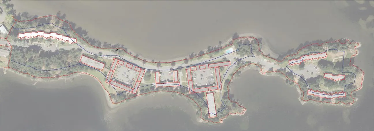
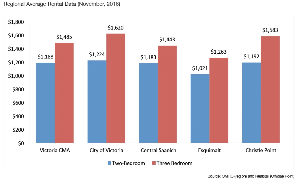
The units are rented at an average rental rate of $1,192 for a 2-bedroom unit (minimum of $923 and maximum of $1,350) and $1,583 for 3 bedroom and townhouse units (minimum of $1,247 and maximum of $1,850). This is comparable with regional market rental rates, as per the figure below:
The buildings on the property are reaching the end of their serviceable use and the applicant wishes to redevelop the site.
Official Community Plan Context
The Town of View Royal Official Community Plan Bylaw No. 811, 2011 designates the site as M-R: Mixed Residential which is described as:
Small lot detached houses, townhouses and low-rise apartments up to 3 storeys and 1.25 FSR, and up to 4 storeys and 1.6 FSR for apartment dwellings.
The site is currently within three Development Permit (DP) Areas as described and regulated within the Town of View Royal Official Community Plan Bylaw No. 811, 2011.
Two DP Areas protect the natural environment:
- Sensitive Terrestrial Ecosystem (across the entire site)
- Natural Watercourse and Shoreline Areas (15m above and below the average high water mark or ‘natural boundary’)
One DP Area regulates the form and character of multi-family residential development, which includes building and landscaping design and materials:
- Mixed Residential Form and Character (across entire site)
PROJECT INFORMATION
The rezoning application proposes a development consisting of 473 townhouse and apartment rental units at a density of 1.15 FSR. This is consistent with the Mixed Residential Land Use Designation within the Official Community Plan (OCP). No OCP amendment is required as part of the application.
The Rezoning Process
An application to rezone a property evaluates the appropriateness of the proposed use and density of the site in the context of on and off-site issues. In considering approval, Council weighs the balance of potential drawbacks with potential benefits of the development for View Royal.
This rezoning proposal is not finalized. This report provides a summary of the existing proposal, and identifies where further work is required. After the Committee of the Whole meeting, staff will work with the applicant to finalize the bylaws and other items required before the application comes forward again to Council for bylaw readings and a Public Hearing.
The application (should it be successful) results in an amendment to the Zoning Bylaw, accomplishing two main things:
- The creation of a new zone; and
- The rezoning of the Christie Point property to that zone.
A Comprehensive Development (CD) Zone is recommended by staff for two reasons:
- There is no existing zone which addresses the specific height, use and density described in the application.
- A CD zone affords Council the greatest amount of control over the zoning and the resulting future development of the site.
While there is a great amount of detail presented in the application, the rezoning process is one step in several which must be undertaken by the applicant to permit the development of the site. There are issues the rezoning can address, and issues that will be considered at Development Permit.
The rezoning process can address:
- Permitted uses
- Permitted densities
- Maximum lot coverage
- Maximum percentage of impermeable surfaces
- Setbacks to property lines that are not from the natural boundary
- Height of buildings
- Size, height and setbacks of accessory structures
- Minimum flood construction level
- Certain conditions of use of the property
The rezoning process cannot address:
- The vehicle or bicycle parking space provision requirements
- The 15m setback to the natural boundary of the sea
- The mechanism by which grade or height of buildings are calculated
- The Development Permit guideline requirements, including architectural styles and environmental protection requirements
- Any regulation contained within the General Regulations in Zoning Bylaw No. 900, 2014
Should the proposal advance to Development Permit stage there may be changes to the proposal and the Development Permit applications will likely contain variances to the zoning regulations within the Zoning Bylaw. This is typical of an application of this size, and is not due to a failure to recognise or adhere to these regulations during the rezoning process. Rather, variances and other changes to the application will address more detailed issues on-site which were not able to be considered at the time of rezoning. The expected variances will be discussed in more detail later in the report.
Proposed Uses
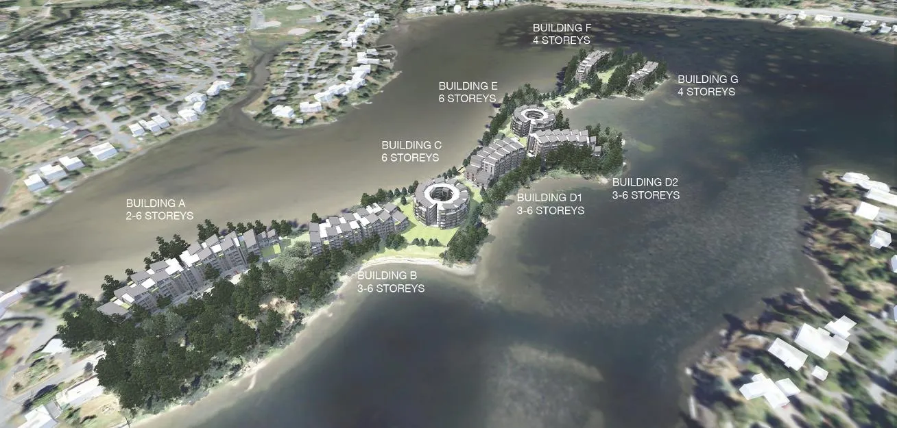
The proposed principal uses for the site are apartment residential and townhouse residential units. The proposal is for rental-only units, which will require a Housing Agreement to secure (this is discussed in more detail later in the report). The proposed height of the buildings is 2 to 6 storeys in eight buildings as illustrated below. The height will be expressed in metres rather than storeys when the zone table is finalized, currently calculated as a maximum of 26m.
Document Images
(3)