Appendix
Aerial Photo and Site Plan (Rogers Tower)
May 3, 2022Page 2351 section
Aerial photography and site planning maps illustrating the proposed location for the Rogers telecommunications tower near Highway 1.
Location: Near Trans-Canada Hwy 1 and Talcott Rd
Site Plan
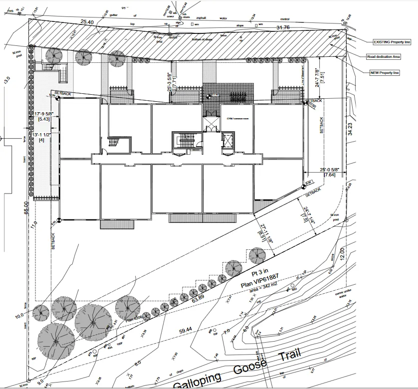
Site and Boundary Information
- EXISTING Property line
- Road dedication Area (represented by hatched region at the north boundary)
- NEW Property line
- Pt 3 in Plan VIP61887: area = 342 m2
- Galloping Goose Trail (located adjacent to the south/southwest property line)
Dimensions and Measurements
- North Boundary: 25.40, 31.76
- East Boundary: 34.23, 12.00
- South Boundary (adjacent to trail): 63.89, 59.44, 9.0
- West Boundary: 13.0, 65.00, 10.0
- Internal Elevation/Site Dimension: 11.0
Setback Requirements
- North Setback: 25'-3 5/8" [7.71]
- Northeast Setback: 24'-7 7/8" [7.51]
- East Setback: 25'-0 5/8" [7.64]
- Southeast Setbacks: 24'-7 1/4" [7.5] and 27'-11 1/8" [8.51]
- West Setbacks: 17'-9 5/8" [5.43] and 13'-1 1/2" [4]
Proposed Building Features
- GYM / common room
- Central stairs and elevator core
- Multiple residential units or building segments as shown in the footprint
Landscape and Site Features
- Landscaping buffers and trees along southern and western boundaries
- Grade and slope contour lines
- Fencing along west and north property edges
Page 235
Extracted from: 2022 05 03 Council Agenda - Agenda - Pdf