Natural Watercourse and Shoreline Development Permit Area Review for 2818 Shoreline Drive
An environmental review by Swell Environmental Consulting Ltd. assessing the impact of development on the shoreline and proposing a native planting restoration plan.
Mikaila Mauro & Jaylem Manhas 2818 Shoreline Drive Victoria, BC V9B 1M6
July 10, 2025
RE: Natural Watercourse and Shoreline Development Permit Area Review for 2818 Shoreline Drive, Victoria, BC, Town of View Royal
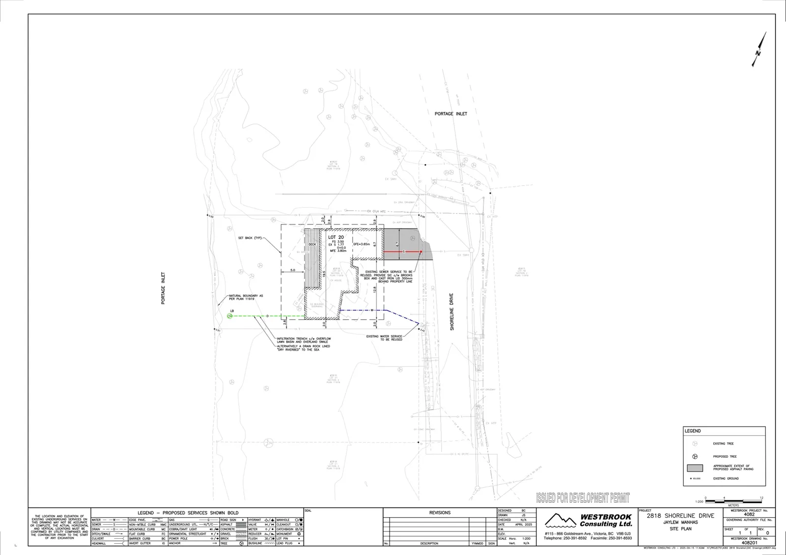
On January 14 & 31, 2025 Lehna Malmkvist, MSc, RPBio. of Swell Environmental Consulting Ltd. (Swell) visited the site at 2818 Shoreline Drive, in the Town of View Royal, to review the existing site conditions and works proposed that are within the Town of View Royal’s Natural Watercourse and Shoreline Areas Development Permit Area (SDPA) (Figures 1 and 2). As per View Royal’s Schedule Q of the Official Community Plan (2011) Bylaw No. 811, the proposal was evaluated with the intent to minimise detrimental impacts to the shoreline. The Natural Watercourse and Shoreline Areas Development Permit Area is an area encompassing a 15-m from the natural boundary of the sea and is referred to as the SDPA in this letter.
Existing Condition
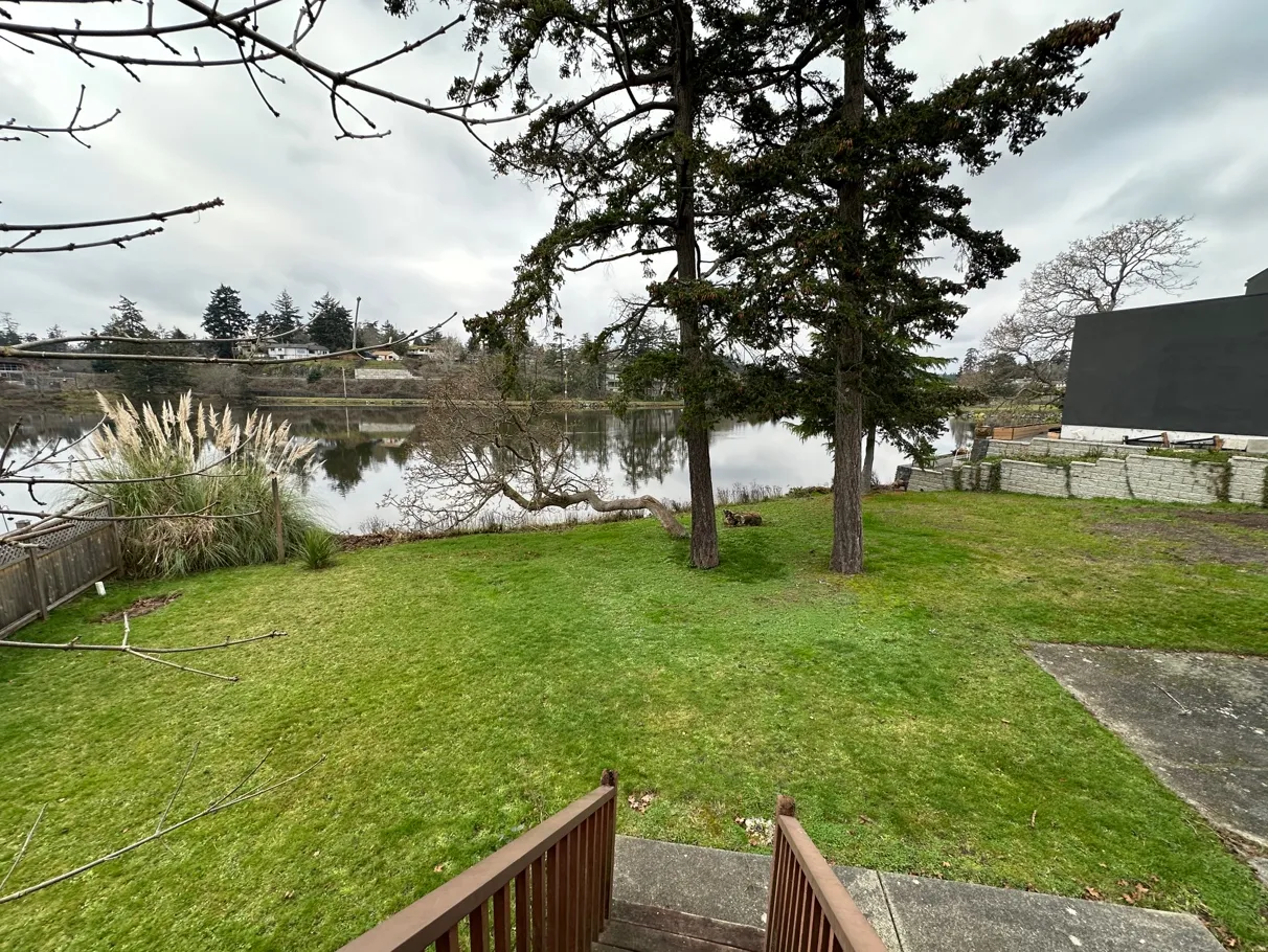
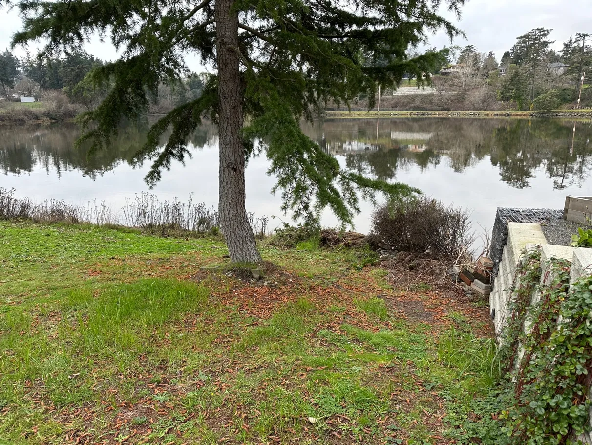
The property has been previously developed with a single family home (now demolished), driveway, landscaping, lawn, patios, etc.
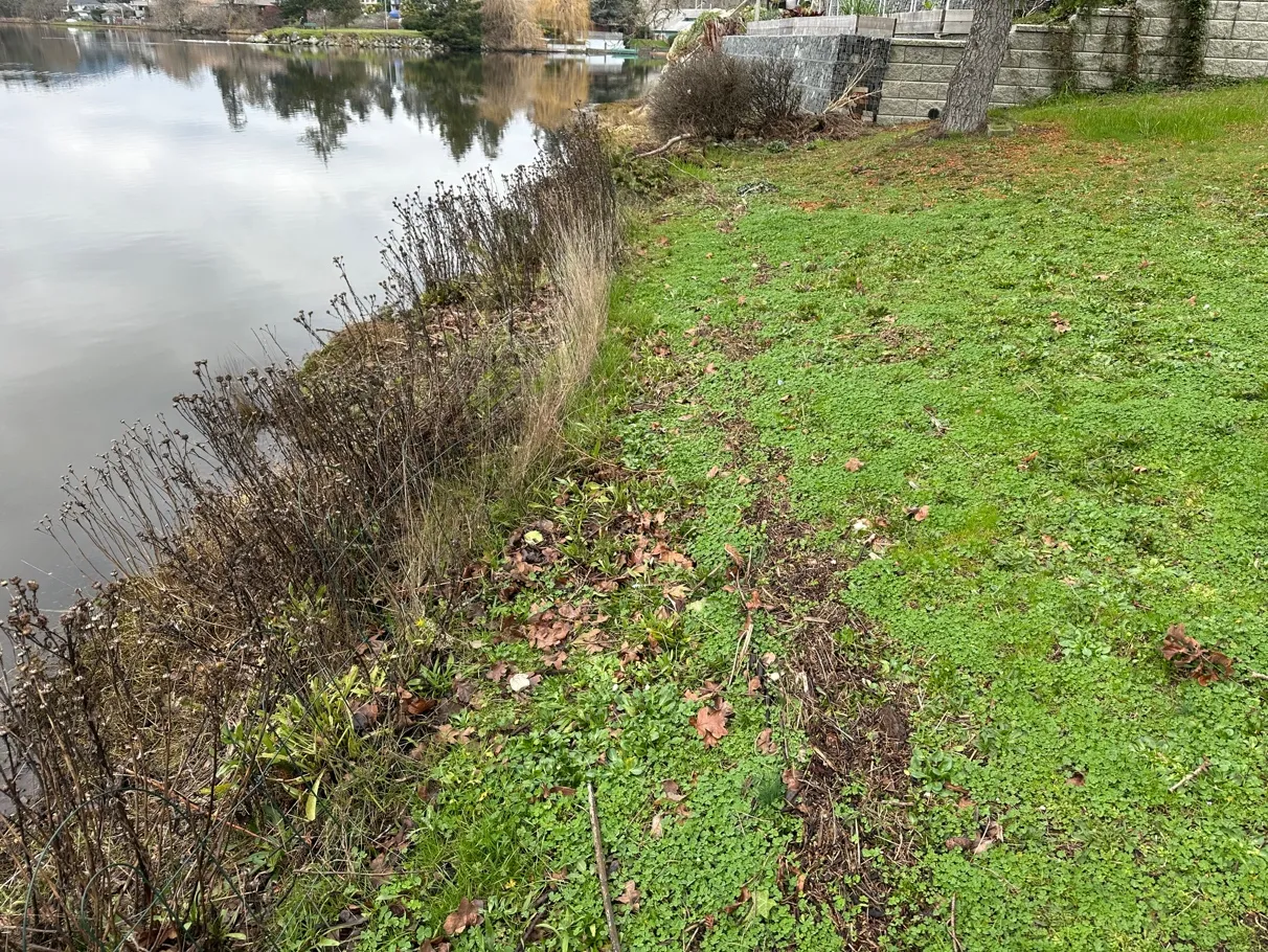
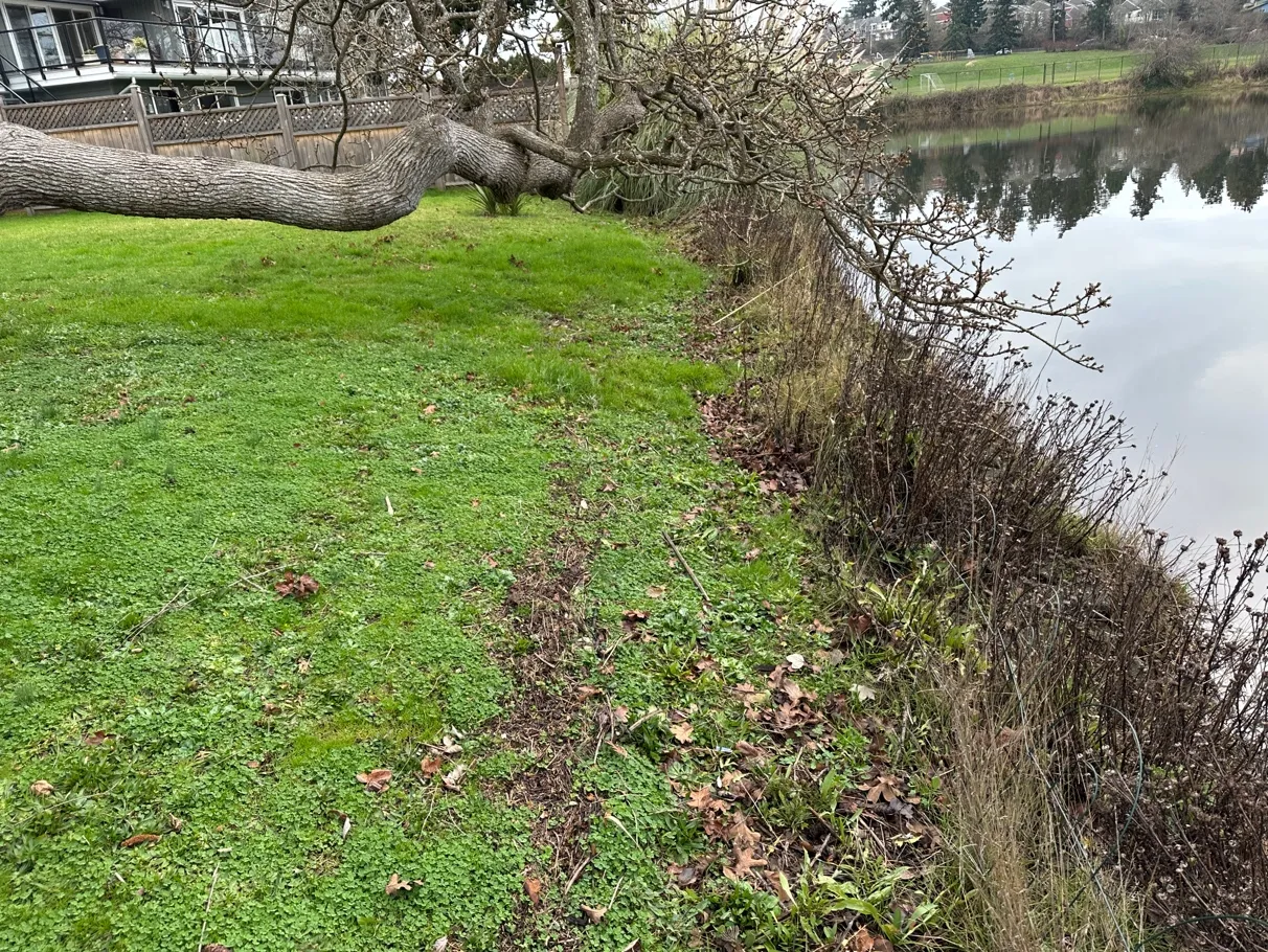
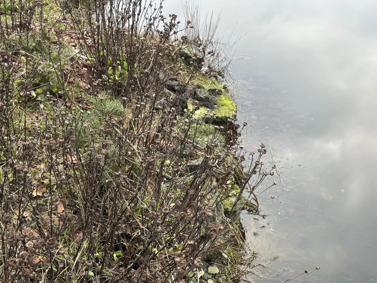
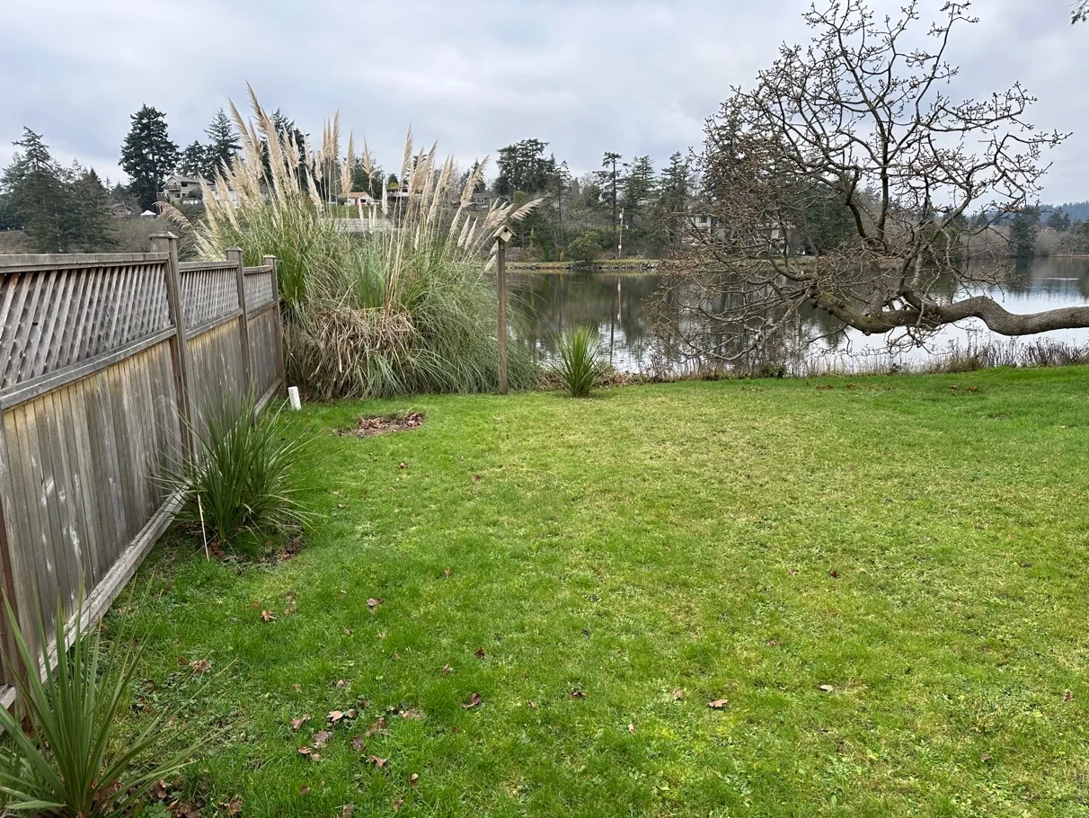
The vegetation in the SDPA consists of lawn with mature Douglas-fir (Pseudotsuga menziesii) trees, garry oak (Quercus garryana), non-native ornamental cedar (Cedrus sp.) and an understory of lawn, with weeds (plantain, cyclamen, clover, etc.), pampas grass, yucca, and other ornamental species, along the shoreline is native gumweed (Grindelia sp.) (Photos 1-6). The shoreline has had broken concrete pieces placed along the edge to provide bank stabilization.
Proposed Works
The owner is proposing to construct a new dwelling on the property, outside the SDPA. The associated works within the SDPA (384.2m²) are to convert the lawn area to native species with shoreline access (Figure 2):
- Removal of part of garage and concrete patio
- Preparation of the SDPA for planting
- Removal of ornamental plantings
- Removal or smothering (e.g. cardboard and mulch and/or soil) of lawn
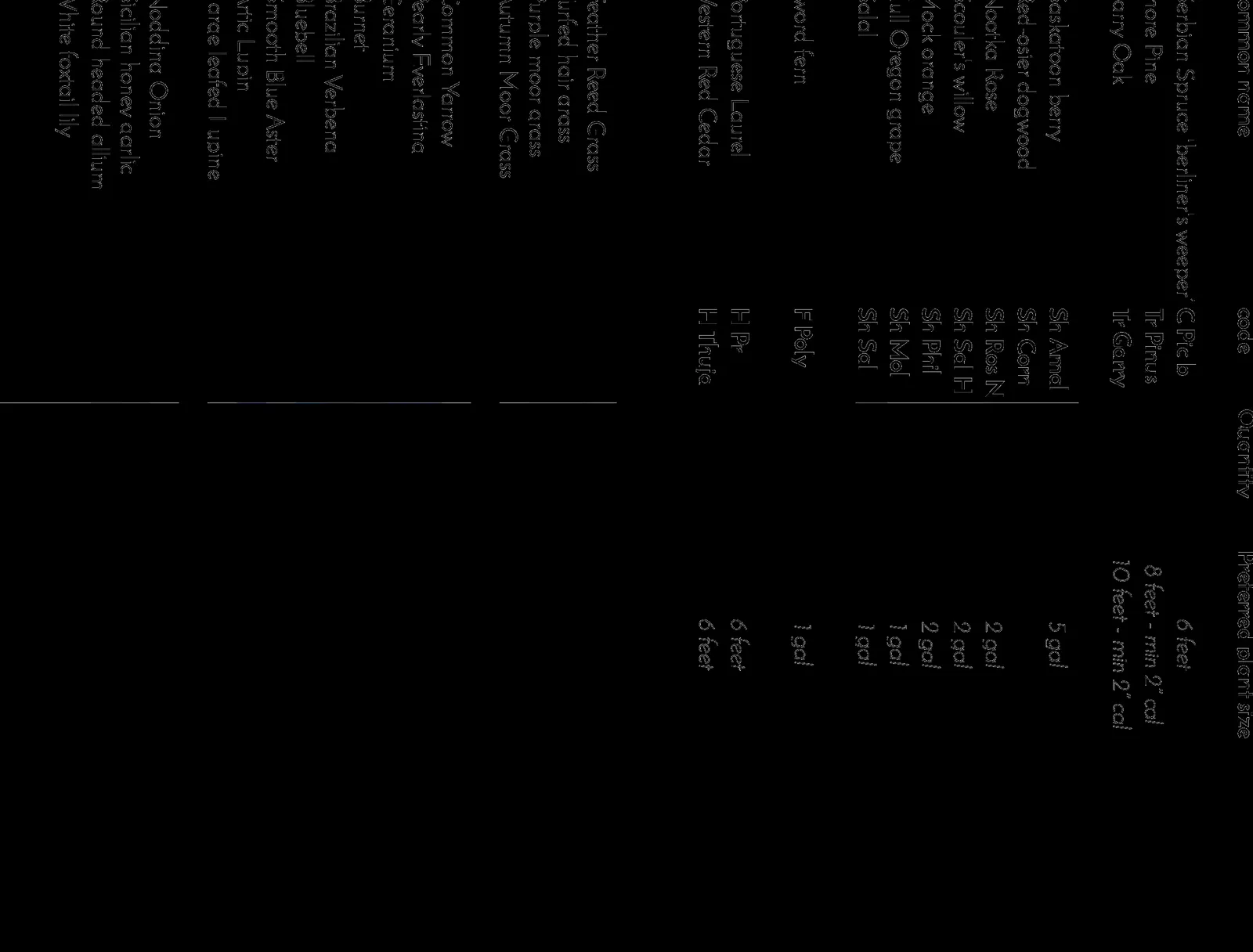
- Removal of ornamental cedar, replaced with two native trees: shore pine and garry oak
- Wooden elevated walkway along the north part of the SDPA to access the water (10.2m² = 2.6%)
- Gravel path through SDPA (15m² = 3.9%)
- Along shoreline remove loose concrete pieces, replace with hand placed rock, under direction of the QEP, to create planting pockets.
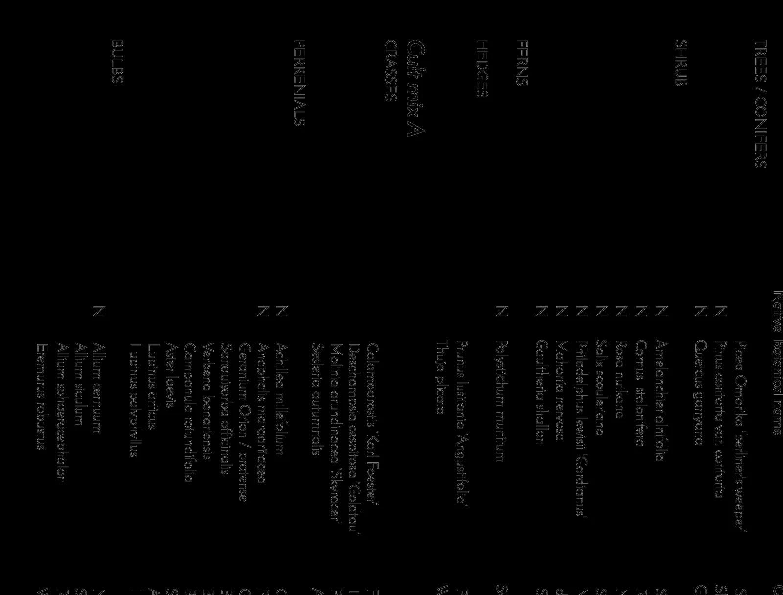
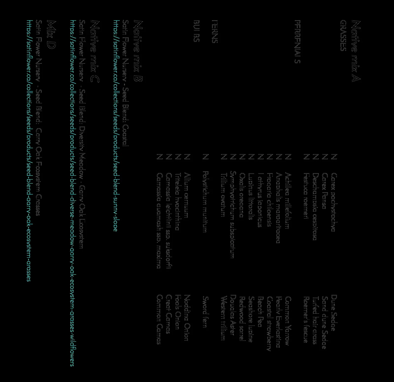
- Planting of native vegetation throughout the SDPA (359m² = 93.5%):
- Native mix A - (75m²) – ferns, perennials, grasses, sedges
- Native mix B - (44m²), retain native gumweed and add salt tolerant seed blend - Coastal Sunny Slope – Satinflower Nurseries
- Native mix C - (95m²) – Diversity Blend – Garry Oak Ecosystem – Satinflower Nurseries
- Native mix D – (80m²) Grass Blend – Garry Oak Ecosystem – Satinflower Nurseries
- Shrubs along the north boundary inside the DPA - (35m²)
- Shrubs in the southwest corner - (25m²) – replace ornamental pampas grass
- Cedar hedge inside the SDPA (5m²)
- native vegetation will be planted to BC Landscape Society standards
- mulch planted area with 10cm of composted mulch following planting
- irrigate for a minimum of 3 years
- maintain area by controlling invasive species
Natural Watercourse and Shoreline Areas Development Permit Area, Bylaw No. 811
The View Royal Official Community Plan (OCP 2011) Bylaw No. 811, identifies the following Guidelines that apply to the Natural Watercourse and Shoreline Areas DPA:
GUIDELINES – GENERAL
i. Development in freshwater riparian areas – e.g. adjacent to streams, lakes, wetlands and other freshwater watercourses – must comply with the requirements of the Riparian Area Regulations.
- N/A - Marine shoreline RAPR does not apply.
ii. Development of riparian and shoreline areas should be limited and not negatively impact the ecological health of the immediate area or impede public access.
- 93.3% of the SDPA will be planted with native species (converted from lawn and ornamental plantings), only development proposed is elevated walkway and gravel paths to access the SDPA and shoreline (6.7%). No change to public access.
iii. Retention of existing healthy riparian and shoreline vegetation should be maximized with any paths, structures or other constructed areas sited to minimize impact on trees and sensitive areas.
- 93.3% of the SDPA will be planted with native species (converted from lawn and ornamental plantings), only development proposed is elevated walkway and gravel paths to access the SDPA and shoreline (6.7%).
iv. Restoration of riparian and shoreline vegetation and habitat, including removal of invasive species, is encouraged for all properties within this Development Permit Area. Development should result in a net increase in native vegetation in almost all circumstances including trees, shrubs and grasses.
- 93.3% of the SDPA will be planted with native species (converted from lawn and ornamental plantings).
v. For shoreline areas heavily impacted by previous development, target the restoration of ecologically appropriate vegetation for an average 15m wide (minimum 5 m) shoreline zone over 50% of the shore length.
- Native plantings are 15m with along the shoreline, except in the location of the gravel paths and walkway (6.7% of the SDPA).
vi. Riparian and shoreline area development should sensitively manage storm water, focusing on infiltration and release of storm water in ways and quantities that mimics natural patterns, avoids scouring and erosion and results in storm water free from pollutants.
- The storwater from the house will be directed drain the storm water in a infiltration trench & overflow lawn basin. or alternatively a drain rock lined dry river bed (Figure 3).
vii. Shoreline protection measures should be limited to those necessary to prevent damage to existing structures or established uses on adjacent upland.
- No shoreline protection measures are proposed, except replacing loose concrete pieces with hand placed rock, to create planting pockets.
viii. In the design of new developments or re‐development, the use of soft engineered and innovative alternatives to stabilizing shorelines and preventing erosion, such as bioengineering rather than traditional hard engineered measures should be used. In general, the harder the construction measure, the greater the impact on shoreline process, including sediment transport, geomorphology and biological functions. Hard" measures refer to those with solid, hard surfaces, such as concrete bulkheads, while "soft" structural measures rely on less rigid materials, such as biotechnical vegetation measures or beach enhancement. There is a range of measures varying from soft to hard that include:
- Vegetation enhancement.
- Upland drainage control.
- Biotechnical measures.
- Beach enhancement.
- Anchor trees.
- Gravel placement.
- Rock (rip rap) revetments.
- Gabions.
- Concrete groins.
- Retaining walls or bulkheads.
- No shoreline protection measures are proposed, except replacing loose concrete pieces with hand placed rock, to create planting pockets.
ix. Where hard measures can conclusively be shown to be the only means of effectively preventing erosion, they should be designed in consultation with a registered professional biologist, qualified environmental professionals and professional engineers, as appropriate.
- N/A – none proposed
x. The preservation and enhancement of native trees and shrub clusters that overhang the waters edge is strongly encouraged as these provide shade, protection and feeding habitat for fish and wildlife.
- Native shrubs will be planted at the north and south ends of the shoreline, and lower salt-tolerant native plantings are proposed along the shoreline.
xi. Any new public pathways or public access should be designed and constructed in consultation with a registered professional biologist or qualified environmental professional, as appropriate, and the Town of View Royal Parks Department.
- N/A
GUIDELINES – MARSH SHORES
Marsh Shores include both mudflat and delta areas, and are generally highly sensitive and productive natural areas. The intertidal (foreshore) zone in this area is typically dynamic, in response to large stream flows and storm events. Though dynamic, the shore zone in these areas is generally accreting rather than eroding. It is important to allow sufficient space to allow these natural sediment processes to occur. With this type of shoreline, the following guidelines apply:
i. Provide a property-specific assessment with respect to building setbacks and shore protection designs, as stream sediment processes are important and will vary from site to site.
- This report addresses this guideline.
ii. Dredging or filling of marsh shore should not be permitted.
- N/A – none proposed
iii. Use of marsh shore areas should be limited to park or conservation uses that do not require structural intrusions.
- N/A – shoreline plantings only proposed
iv. Where shore protection measures are necessary, make use of “beach nourishment” designs, which add appropriately sized material to the upper beach, creating a natural beach slope and beach armour.
- N/A – no armouring proposed
v. Sea walls and rip rap embankments should not be used to protect these shoreline areas.
- N/A – no seawalls or riprap proposed
Environmental Impacts and Recommendations
The possible environmental impacts of the construction work (excavation) and the restoration work (invasive species removal and planting), in an area adjacent to the marine environment are:
- damage to trees
- erosion of bare soil
- sedimentation of the marine environment
- spills
These potential impacts are minimised by the following Environmental Protection Measures.
Protecting ecological features
- Locations no-go zones, retained trees and vegetation, and sensitive areas are fenced/marked and communicated to all personnel, including sub-contractors and trades.
- Avoid placing soil/gravel piles and heavy construction materials around roots of trees to be retained, or otherwise cutting into root zones or compacting soils by driving and parking vehicles on root zones.
- Follow arborist’s recommendations for tree protection.
- Pre-clearing nest survey for removal of trees/vegetation during breeding season (Feb 15 to Aug 15)
Erosion & Sediment Control
- Excavations, removal of concrete pieces and ornamental plantings, and preparation of lawn to convert to native plantings, to be conducted during forecasted dry weather.
- Do not direct water runoff from the site or dewatering from excavations directly into the marine environment. If dewatering of excavations is required, the Environmental Monitor must be consulted to determine where runoff can be directed or if sediment settling facilities (tanks, berms) are required.
- Cover exposed soils, if needed during rainfall (e.g. poly, tarps, mulch, seeding, ‘rough and loose’ treatment)
- Installing erosion and sediment control measures for the construction (e.g. sediment fencing or mounded mulch) to prevent sediment laden runoff from entering the SDPA or marine environment;
- Ensure soil and debris stockpiles are placed away from the shoreline and sediment-laden water cannot flow into the waterbodies.
- If needed in the restoration area, install biodegradable coir mats on the shoreline slope to retain soils after invasive species are removed;
- Contact Environmental Monitors immediately with any concerns.
Spill Prevention and Response
- Equipment must be inspected for leaks prior to beginning work.
- Spill response kits (capable of addressing the volume of fuel/oils/chemicals on site) are on site when any heavy machinery is working, and operators are trained in their use.
- Equipment refueling is at a designated location and >30 m from aquatic ecosystems or isolated from stormdrains.
- Fuel generators must be placed in a spill-proof container capable of addressing the maximum volume of fuel involved (e.g. plastic bin, or other impermeable containment area such as poly-lined bermed depression).
- Store all fuel cans in spill-proof containers (e.g. as above).
- Concrete wash-water and wet concrete is highly alkaline and toxic to fish and other aquatic organisms. All concrete wash-water from equipment, trucks and/or hand tools needs to be directed to a settling area away from runoff paths to the waterbodies. Freshly poured concrete needs to be covered when rain is forecasted or runoff needs to be isolated from waterbodies during the curing process.
- In case of spills, the following general steps are recommended:
- Stop source of spill/prevent further spillage (turn off valves, right overturned containers)
- Block spill from reaching aquatic environment or pathways to waterbodies
- Block spill from spreading
- Call Environmental Monitors
- Clean up spilled materials
SDPA Restoration & Maintenance
- Preparation of the SDPA for planting (retain native trees and shoreline gumweed)
- Removal of ornamental plantings
- Removal or smothering (e.g. cardboard and mulch and/or soil) of lawn
- Native Mix A Area - should be mulched with 10 cm composted mulch, amend soils in Native Mix B, C, D areas as needed
- Irrigation
- Growing Seasons 1 and 2 - watering 2/week deeply during the growing season or if plants are wilting
- Growing Seasons 3 and onwards - Water as needed to establish and wean plants off irrigation
- Maintenance
- Invasive species removal, by hand, a minimum of 3 times/growing season for a minimum of 3 growing seasons
Environmental Monitoring
- Environmental Monitor to oversee construction activities, including (but not limited to)
- pre-construction meeting
- pre-clearing nest survey (Feb 15-Aug 15)
- during installation of erosion protection measures (e.g. silt fence)
- during removal of lawn and ornamental species, and native species planting
- during removal of loose concrete pieces and hand placement of rock to create planting pockets along the shoreline
- heavy rainfall events greater than 10 mm until such time that the QEP is satisfied that the ESC and other protective measures are containing heavy rainfall as designed.
- at completion
In summary, the footprint of the proposed work (elevated walkway and gravel paths) in the SDPA is small (approx. 25.2 m² / 6.5% of the SDPA), the rest of the SDPA (359m² / 93.5%) will be planting with native plants. The proposed work is expected to improve the ecological condition of the SDPA. If the environmental protection measures are implemented, no sedimentation or spills should occur and there are no damage should occur to the SDPA or marine environment.
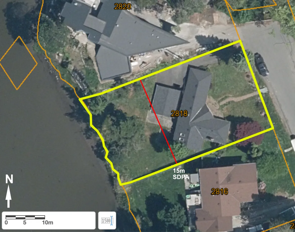
Figure 2. Proposed house addition and restoration area
Site Photos
Document Images
(3)