Marine Habitat Review Private Recreational Dock
A desktop habitat review for a proposed private recreational dock at 302 Bessborough Avenue, detailing project specifications and mitigation measures for marine life.
1 INTRODUCTION
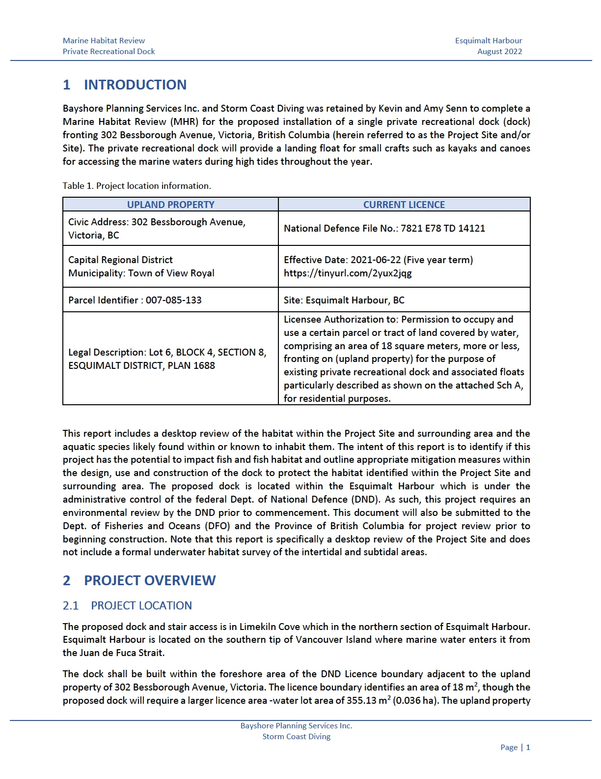
Bayshore Planning Services Inc. and Storm Coast Diving was retained by Kevin and Amy Senn to complete a Marine Habitat Review (MHR) for the proposed installation of a single private recreational dock (dock) fronting 302 Bessborough Avenue, Victoria, British Columbia (herein referred to as the Project Site and/or Site). The private recreational dock will provide a landing float for small crafts such as kayaks and canoes for accessing the marine waters during high tides throughout the year.
Table 1. Project location information.
| UPLAND PROPERTY | CURRENT LICENCE |
|---|---|
| Civic Address: 302 Bessborough Avenue, Victoria, BC | National Defence File No.: 7821 E78 TD 14121 |
| Capital Regional District Municipality: Town of View Royal | Effective Date: 2021-06-22 (Five year term) https://tinyurl.com/2yux2jqg |
| Parcel Identifier: 007-085-133 | Site: Esquimalt Harbour, BC |
| Legal Description: Lot 6, BLOCK 4, SECTION 8, ESQUIMALT DISTRICT, PLAN 1688 | Licensee Authorization to: Permission to occupy and use a certain parcel or tract of land covered by water, comprising an area of 18 square meters, more or less, fronting on (upland property) for the purpose of existing private recreational dock and associated floats particularly described as shown on the attached Sch A, for residential purposes. |
This report includes a desktop review of the habitat within the Project Site and surrounding area and the aquatic species likely found within or known to inhabit them. The intent of this report is to identify if this project has the potential to impact fish and fish habitat and outline appropriate mitigation measures within the design, use and construction of the dock to protect the habitat identified within the Project Site and surrounding area. The proposed dock is located within the Esquimalt Harbour which is under the administrative control of the federal Dept. of National Defence (DND). As such, this project requires an environmental review by the DND prior to commencement. This document will also be submitted to the Dept. of Fisheries and Oceans (DFO) and the Province of British Columbia for project review prior to beginning construction. Note that this report is specifically a desktop review of the Project Site and does not include a formal underwater habitat survey of the intertidal and subtidal areas.
2 PROJECT OVERVIEW
2.1 PROJECT LOCATION
The proposed dock and stair access is in Limekiln Cove which in the northern section of Esquimalt Harbour. Esquimalt Harbour is located on the southern tip of Vancouver Island where marine water enters it from the Juan de Fuca Strait.
The dock shall be built within the foreshore area of the DND Licence boundary adjacent to the upland property of 302 Bessborough Avenue, Victoria. The licence boundary identifies an area of 18 m², though the proposed dock will require a larger licence area - water lot area of 355.13 m² (0.036 ha). The upland property is part of a residential neighbourhood that surrounds Limekiln Cove. See Figure 1. For the general location of the upland property and Figure 2. For the proposed dock location.
2.2 PROJECT DESCRIPTION
The plan for construction will be to replace a portion of the existing stairway access and platforms on the upland property and install a raised dock within the foreshore area that connects perpendicular to the rocky shoreline. The installation will coincide with DFO’s preferred fisheries window for the area (Area 19 - Victoria) which is as follows: The Summer Window is July 1 - October 1 and the Winter Window is December 1 - February 15 of any given year. (British Columbia Marine/Estuarine Timing Windows for the Protection of Fish and Fish Habitat-South Coast and Lower Fraser Areas).
The proposed construction of the private dock will consist of the removal of the existing landings and walkways within the upland area. The upper stairway, currently in place within the property boundary, will remain to provide access to a new upper landing platform that connects with stairs to a lower landing platform within the licenced area. Connected to the lower platform will be a 40’ (12.2 m) actuating gangway (ramp) that connects to a float (dock) 12’ x 32’ (3.66 m x 10 m) which is supported by four piles ~12” (0.30 m) diameter each having four pile stops to prevent the float from settling on the seabed during low tides. Floatation for the dock will be of foam material encased in plastic with float stops on supporting pilings providing 0.5 m clearance from floor of seabed. This clearance provides ample room for entry of motorless vessels such as kayaks and canoes proposed to be used from the dock. The ramp and dock will be prefabricated off-site and then the components including the piles will be floated to the site by barge and installed using a marine crane. The proposed construction drawings referenced within this report are preliminary and all will require final review by engineer prior to proceeding.
The planned timing of construction shall be conducted during high tide events where movement and use of vessels is coordinated with area of works and level of tide to prevent grounding in shallow areas. Anticipated construction dates shall fall within the fisheries window in any given year for the Project Site and are expected to last 7-10 business days in total. See Section 6.1 and 6.2 for further details of proposed design and construction phases of the project.
See Appendix A. Private Recreational Dock Construction Plan for visual of proposed dock plans and stair access. Also included are photographs of the current stairs, landing access, vegetation, the natural property boundary, and views into the Cove from the Project Site location in Appendix B.
2.3 SPECIAL INTEREST GROUPS
As part of the proposed construction of the private recreational dock, a consultation process with local First Nations will occur. All efforts shall be made to provide open and concise information about the Project to interested parties when requested.
A Request for known Archaeological Sites with the BC Provincial Archaeology Branch has been made. However, given the upland conditions of the property and the relatively small area proposed to be disturbed to install stairs and piles, expectations of an archaeological “chance-find” are considered low. However, if cultural finds are identified activities must be halted and the Archaeology Branch contacted at 250-953-3334 for direction.
3 STUDY METHODS
3.1 LITERATURE REVIEW
A review of publicly available information was conducted for the Project Site and surrounding area to support appropriate design, construction, and use of the proposed dock. The collected information facilitates the characterization of potential habitat features, species presence, migratory, refuge or spawning areas, and potential species at risk within and surrounding the Study Area. A list of reviewed data sources for relevant information is located within the reference section.
3.1.1 ANTICIPATED HABITAT AND SPECIES UTILIZATION
3.1.1.1 Terrestrial and Upper Intertidal Areas
The identified biogeoclimatic zone for the Project Site is Coastal Douglas Fir (CDF), within a moist maritime subzone (CDFmm). This zone covers a small area of BC’s south coast, including a band of lower elevation along Southeastern Vancouver Island, the Gulf Islands, and a fringe of mainland along the Strait of Georgia. The project location is in an area of the island that is typically drier and although it is in an urban setting, it can be characterized by the presence of Garry oak (Quercus garryana), Arbutus (Arbutus menziesii) and wildflowers including various lilies and orchids. These foreshore areas provide habitat for a variety of animal species that include blacktail deer (Odocoileus hemionus columbianus), black bear (Ursus americanus), cougar (Puma concolor), and other small mammals and birds. The coastline shelters many species of waterfowl, and the islets offshore support colony-nesting species such as the glaucous-winged gull (Larus glaucescens) and Brandt's cormorant (Phalacrocorax penicillatus).
3.1.1.2 Intertidal Zone
The Project Site is located within the intertidal area of Limekiln Cove. This portion of the cove can be characterized as having a chart depth of < 0m with warm water temperatures (9-15 °C) and relatively flat slope (0-5% grade). Limekiln cove is considered semi protected and has a moderate to low wave exposure due to the depth and grade of the foreshore area. The shoreline within the coves of the harbour can be described as having intertidal mudflats with rocky islets or outcrops as seen specifically within the Project Site (AMR 2004). Indicator species found within these valued habitat features may consist of lichens (Verrucaria), green alga (Enteromorpha), acorn barnacle (Balanus glandula), and rock weed (Fucus distichus) (GeoBC 2008). Soft substrates deeper in the foreshore area provide ideal habitat conditions for invertebrates to remain buried within, specifically shellfish.
See Appendix B. for pictures of shoreline within the Project Site and proposed dock location.
3.1.2 SPECIES AT RISK
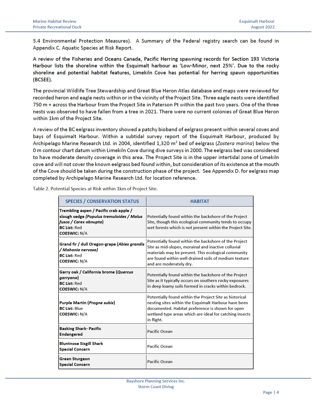
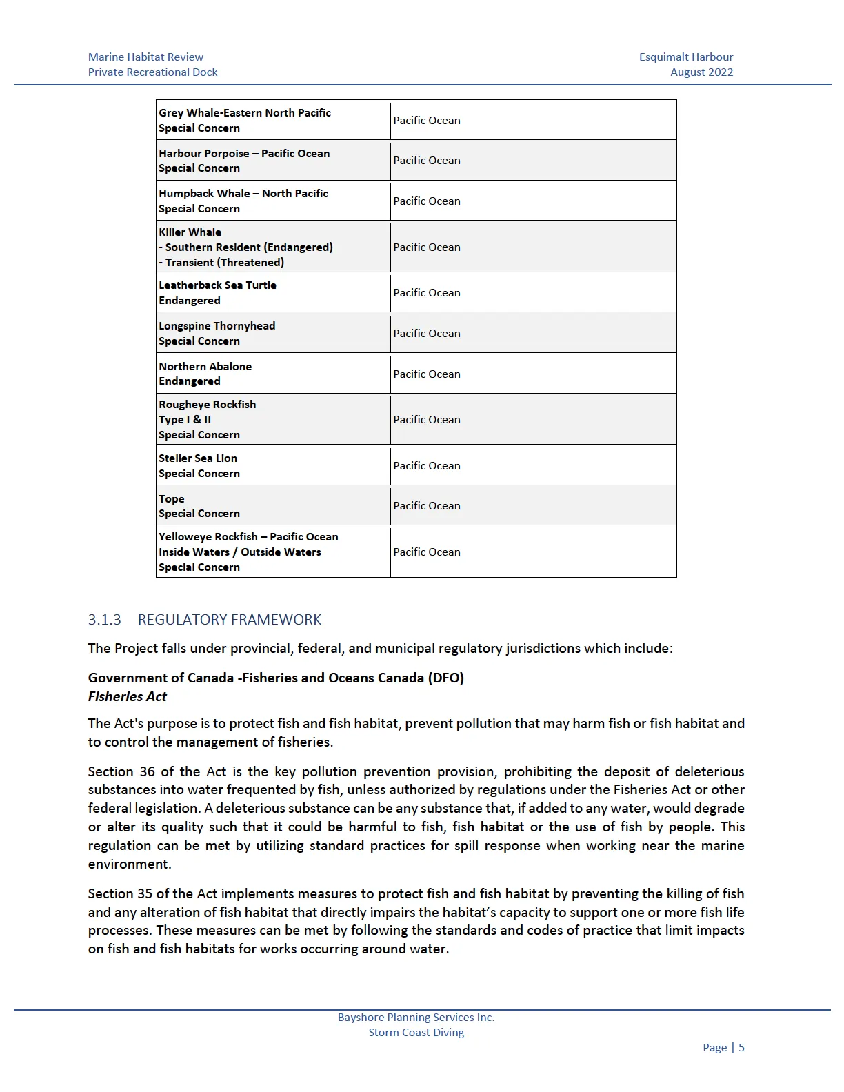
A review of potential species at risk within a 1 km search boundary of the Project Site was conducted. This search consisted of a review of the BC Conservation Data Centre (BC CDC) database as well as the Federal Species at Risk public registry and map. Although mapped data from the BC CDC was not available, further requests to them identified four areas within the Esquimalt Harbour where species at risk were found in the past. Table 1. Below summarizes potential species at risk listed from the BC CDC and the Federal Registry within the search area of the Project Site. The Federal registry search identified potential habitat uses for several aquatic species at risk within the search boundary, though no critical habitat was identified. Many of the listed marine species are of concern and have the potential to move through the surrounding waters of the Esquimalt Harbour but may not reside specifically within the Project Site. Understanding this, appropriate mitigation measures shall be applied during the construction phase of the project (See Section 5.4 Environmental Protection Measures). A Summary of the Federal registry search can be found in Appendix C. Aquatic Species at Risk Report.
A review of the Fisheries and Oceans Canada, Pacific Herring spawning records for Section 193 Victoria Harbour lists the shoreline within the Esquimalt harbour as ‘Low-Minor, next 25%’. Due to the rocky shoreline and potential habitat features, Limekiln Cove has potential for herring spawn opportunities (BCSEE).
The provincial Wildlife Tree Stewardship and Great Blue Heron Atlas database and maps were reviewed for recorded heron and eagle nests within or in the vicinity of the Project Site. Three eagle nests were identified 750 m + across the Harbour from the Project Site in Paterson Pt within the past two years. One of the three nests was observed to have fallen from a tree in 2021. There were no current colonies of Great Blue Heron within 1km of the Project Site.
A review of the BC eelgrass inventory showed a patchy bioband of eelgrass present within several coves and bays of Esquimalt Harbour. Within a subtidal survey report of the Esquimalt Harbour, produced by Archipelago Marine Research Ltd. in 2004, identified 1,320 m² bed of eelgrass (Zostera marina) below the 0 m contour chart datum within Limekiln Cove during dive surveys in 2000. The eelgrass bed was considered to have moderate density coverage in this area. The Project Site is in the upper intertidal zone of Limekiln cove and will not cover the known eelgrass bed found within, but consideration of its existence at the mouth of the Cove should be taken during the construction phase of the project. See Appendix D. for eelgrass map completed by Archipelago Marine Research Ltd. for location reference.
Table 2. Potential Species at Risk within 1km of Project Site.
| SPECIES / CONSERVATION STATUS | HABITAT |
|---|---|
| Trembling aspen / Pacific crab apple / slough sedge (Populus tremuloides / Malus fusca / Carex obnupta) BC List: Red COESWIC: N/A |
Potentially found within the backshore of the Project Site, though this ecological community tends to occupy wet forests which is not present within the Project Site. |
| Grand fir / dull Oregon-grape (Abies grandis / Mahonia nervosa) BC List: Red COESWIC: N/A |
Potentially found within the backshore of the Project Site as mid-slopes, morainal and inactive colluvial materials may be present. This ecological community are found within well drained soils of medium texture and are moderately dry. |
| Garry oak / California brome (Quercus garryana) BC List: Red COESWIC: N/A |
Potentially found within the backshore of the Project Site as it typically occurs on southern rocky exposures in deep loamy soils formed in cracks within bedrock. |
| Purple Martin (Progne subis) BC List: Blue COESWIC: N/A |
Potentially found within the Project Site as historical nesting sites within the Esquimalt Harbour have been documented. Habitat preference is shown for open wetland type areas which are ideal for catching insects in flight. |
| Basking Shark- Pacific Endangered |
Pacific Ocean |
| Bluntnose Sixgill Shark Special Concern |
Pacific Ocean |
| Green Sturgeon Special Concern |
Pacific Ocean |
| Grey Whale-Eastern North Pacific Special Concern |
Pacific Ocean |
| Harbour Porpoise – Pacific Ocean Special Concern |
Pacific Ocean |
| Humpback Whale – North Pacific Special Concern |
Pacific Ocean |
| Killer Whale - Southern Resident (Endangered) - Transient (Threatened) | Pacific Ocean |
| Leatherback Sea Turtle Endangered |
Pacific Ocean |
| Longspine Thornyhead Special Concern |
Pacific Ocean |
| Northern Abalone Endangered |
Pacific Ocean |
| Rougheye Rockfish Type I & II Special Concern |
Pacific Ocean |
| Steller Sea Lion Special Concern |
Pacific Ocean |
| Tope Special Concern |
Pacific Ocean |
| Yelloweye Rockfish – Pacific Ocean Inside Waters / Outside Waters Special Concern |
Pacific Ocean |
3.1.3 REGULATORY FRAMEWORK
The Project falls under provincial, federal, and municipal regulatory jurisdictions which include:
Government of Canada -Fisheries and Oceans Canada (DFO) Fisheries Act The Act’s purpose is to protect fish and fish habitat, prevent pollution that may harm fish or fish habitat and to control the management of fisheries.
Section 36 of the Act is the key pollution prevention provision, prohibiting the deposit of deleterious substances into water frequented by fish, unless authorized by regulations under the Fisheries Act or other federal legislation. A deleterious substance can be any substance that, if added to any water, would degrade or alter its quality such that it could be harmful to fish, fish habitat or the use of fish by people. This regulation can be met by utilizing standard practices for spill response when working near the marine environment.
Section 35 of the Act implements measures to protect fish and fish habitat by preventing the killing of fish and any alteration of fish habitat that directly impairs the habitat’s capacity to support one or more fish life processes. These measures can be met by following the standards and codes of practice that limit impacts on fish and fish habitats for works occurring around water.
Government of Canada- Department of National Defense Environmental Review Impact Assessment Act As the project is located within the identified federal land in the Esquimalt Harbour it requires the completion of an impact assessment, as required under the Impact Assessment Act, which will be reviewed by the Department of National Defence CFB Esquimalt. The purpose of this Act is to outline the federal process of an impact assessment for projects occurring within Federal land and to prevent significant adverse environmental effects.
Ministry of Forest, Lands, Natural Resource Operations and Rural Development Land Act- Private Moorage The construction of a private moorage facility in this area falls under General Permission (GP) area. As part of a GP submission, the dock applicant must meet several requirements which may include the completion of a Marine Habitat Assessment for the Project Site.
Transport Canada Canadian Navigable Waters Act This Act defines a Minor Works Order which allows works such as this Project, as it meets the assessment criteria and can proceed without an application for approval.
Town of View Royal, Official Community Plan (OCP) Bylaw No. 811 The location of the Project Site is identified within a development permit area (shoreline areas) which is established to protect the natural environment from hazardous conditions that may arise from proposed development. The OCP lays out guidelines for the construction and replacement of existing docks and boat launch facilities and those developments which occur in rocky shoreline types. As such, the applicant must obtain a development permit with the Town of View Royal and submit an impact assessment report prior to proceeding with construction.
4 POTENTIAL IMPACTS
4.1 DESIGN AND OPERATION
The design and operation considerations of the proposed dock structure has considered the potential negative impacts to the marine environment. These potential impacts include:
- Damage to marine and foreshore habitat in areas where a dock, stairs and landings make direct contact with the substrate and soils present.
- Instances of chemical/heavy metal leaching into the marine environment where docks/pilings are constructed from preservative-coated lumber.
- Pilings can change water flow within the project area and surroundings causing erosion, scouring and sedimentation.
- Docks can block sunlight and cast shade upon the underwater habitats leading to lower light availability for plant photosynthesis.
- Increased boat traffic in an area can negatively impact the environment as a result of propeller damage to standing vegetation. Propeller wash can move and deposit sediment either displacing algae or seagrass that may be in the area, burying it or both.
4.2 CONSTRUCTION
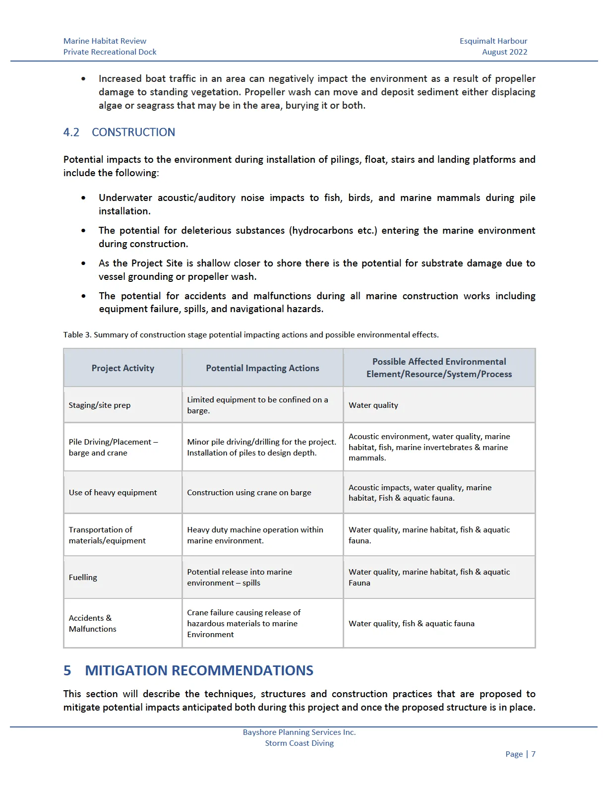
Potential impacts to the environment during installation of pilings, float, stairs and landing platforms and include the following:
- Underwater acoustic/auditory noise impacts to fish, birds, and marine mammals during pile installation.
- The potential for deleterious substances (hydrocarbons etc.) entering the marine environment during construction.
- As the Project Site is shallow closer to shore there is the potential for substrate damage due to vessel grounding or propeller wash.
- The potential for accidents and malfunctions during all marine construction works including equipment failure, spills, and navigational hazards.
Table 3. Summary of construction stage potential impacting actions and possible environmental effects.
| Project Activity | Potential Impacting Actions | Possible Affected Environmental Element/Resource/System/Process |
|---|---|---|
| Staging/site prep | Limited equipment to be confined on a barge. | Water quality |
| Pile Driving/Placement – barge and crane | Minor pile driving/drilling for the project. Installation of piles to design depth. | Acoustic environment, water quality, marine habitat, fish, marine invertebrates & marine mammals. |
| Use of heavy equipment | Construction using crane on barge | Acoustic impacts, water quality, marine habitat, Fish & aquatic fauna. |
| Transportation of materials/equipment | Heavy duty machine operation within marine environment. | Water quality, marine habitat, fish & aquatic fauna. |
| Fuelling | Potential release into marine environment – spills | Water quality, marine habitat, fish & aquatic Fauna |
| Accidents & Malfunctions | Crane failure causing release of hazardous materials to marine Environment | Water quality, fish & aquatic fauna |
5 MITIGATION RECOMMENDATIONS
This section will describe the techniques, structures and construction practices that are proposed to mitigate potential impacts anticipated both during this project and once the proposed structure is in place. In addition to this document, a management plan will be developed to mitigate potential impact through discussion and commitments to appropriate best management practices (BMPs) with the dock builder.
5.1 DESIGN AND OPERATION MITIGATION MEASURES
The proposed private moorage facility will have the following design features and intended operational use to mitigate the potential negative effects that it may have on the surrounding species and their habitat.
- The stair access and landings are proposed to be installed within the existing areas of the previous landing to prevent further disturbance of vegetation on the rocky shoreline. The proposed design reduces the number of landing platforms from four to two. Reduction of landings provides greater areas for flora to become established.
- Support pilings for the proposed float shall have pile stops which will prevent the float from bottoming on the seabed, but also allowing for use during high tide windows.
- Pilings proposed for the construction are of marine grade coated steel and shall be installed with a cathode protection on all pilings to help mitigate corrosion.
- Due to the sitting location of the proposed dock, scouring and or erosion is not anticipated as proposed boat use shall only be non-motorized.
- The use of permeable (aluminum grating) over the gangway (ramp) provides sunlight penetration to the habitat located below the dock.
The intent of the dock design should use materials which reduce the impact on the marine environment to the greatest degree possible. It is understood that a detailed design of the stairway access, platforms, ramp and float will commence after permits are granted. These designs shall reflect the recommended mitigation measures above. A geotechnical assessment has also been recommended at the detailed design phase to confirm load capacity of platforms and float piles.
5.2 CONSTRUCTION MITIGATION MEASURES
Habitat impacts are expected to be temporary and short-term during the three Phases of construction. No changes to the habitat are expected that would impair its capacity to support the life processes of fish and other marine organisms that may be present. All work should be manageable within standard construction practices, and if the owner and contractor follow the recommendations provided in this document.
During Phase 1 of the proposed dock construction, removal of the existing platforms and stairways will occur. Access and removal of materials shall be done from the upland property. All efforts shall be made to limit the impact of existing flora/habitat during the removal process. It is recommended that native plants be salvaged from known areas of impact prior to deconstruction. Replanting of native plants can then occur once new construction is complete.
Phase 2 of the construction will entail the placement of four steel pilings (estimated sizing 12” (0.30 m) diameter) which will be floated to the Site on a barge. Pilings supporting the float will be placed during tide events when they can be driven into the seabed (min. 3.7 m depth) using a vibro hammer suspended from a crane on a barge. This should be conducted when there is sufficient depth to avoid potential grounding and propeller wash damage to the substrate. The substrate below the proposed dock footprint consists of soft sediment mud. A vibro hammer is expected to be sufficient to complete the pile installations in the mud substrate and potentially where boulder and cobble exist; however, if hard substrate is encountered below mud/boulder/cobble the use of an impact hammer may be required to bring the piles to refusal depth. If inserting pilings into bedrock, it may be decided to drill the pilings into place. Drilling operations would include a down hole hammer drill with the piling acting as the drill casing, and sediment controlled using a cyclonic separation. Turbidity in the water column will be minimized through this process and monitored for acceptable levels. All equipment is to be well maintained and free of oil leaks.
Phase 3 consist of the assembling of the stairs, landing platforms, gangway (ramp) and float. The aluminum gangway and float are to be prefabricated off-site. As with the pilings, components of the dock will be floated to the site by barge. The remaining materials used in the stairs and landing platforms will be brought to and constructed from the upland property. The gangway is proposed to be composed of aluminum grating to allow for extensive light penetration. All materials shall be installed with the use of a spud barge and crane. Repositioning of the Barge will be kept as efficient as possible minimizing the impact of the spuds throughout the construction process. Vessels, including the pile driving barge and work boats, will be operated in water deep enough to prevent grounding and propeller wash disturbance of the foreshore and seabed. The barge spud deployment will be limited to the minimum necessary for safe operation of barge mounted equipment, and proper installation of project components.
5.3 RESIDUAL IMPACTS
There are no anticipated residual impacts from the construction or use of the proposed private moorage facility on the surrounding habitat and anticipated species. The total footprint on the seabed covered by pilings is estimated at 0.28 m² (4 x 0.30 m diameter piles). Overtime, pilings will provide additional attachment surfaces for marine life. The estimated footprint coverage of the gangway and float is approximately 54.9 m². Shading of the dock is anticipated to be minimal due to the elevation of the narrow walkway above the water and from the open exposure of the sun as it tracks across the sky during the day providing sufficient sunlight to the seabed.
5.4 ENVIRONMENTAL PROTECTION MEASURES
The purpose of this section is to ensure environmental compliance as per the Fisheries Act and to identify Best Management Practices (BMP)’s during the construction phase of the project.
The marine construction contractor(s) is to reference Protection Measures as identified below and with the following agency guidelines:
- Canadian Water Quality Guidelines, and the British Columbia Approved & Working Water Quality Guidelines: for protection of aquatic life, wildlife, and their habitat.
- Disposal of Waste Material following the British Columbia Ministry of Environment & Climate Change Strategy- Environmental Management Act; and
- Best Management Practice for Pile Driving and Related Operations – BC Marine and Pile Driving Contractors Association – November 2003.
General environmental protections measures shall include:
- Conduct a pre-construction tailboard meeting to review construction schedule, spill control and sediment control measures as per environmental protection plans;
- Installation of the dock piles for the project is to take place during the DFO marine reduced risk window for the area (Area 19 - Victoria) which is as follows: The Summer Window is July 1 - October 1 and the Winter Window is December 1 - February 15 of any given year. (British Columbia Marine/Estuarine Timing Windows for the Protection of Fish and Fish Habitat-South Coast and Lower Fraser Areas).
- Pile driving should not be conducted during adverse weather conditions, high winds and rough sea conditions.
- Marine weather forecasts and tide tables are to be consulted prior to commencing work to avoid adverse environmental interactions.
- Pile driving will follow Best Management Practices for Pile Driving and Related Operations, and Measures to Avoid Harm (DFO 2022).
- Pile driving will be achieved from a small barge with tide moving from low to high when there is sufficient water depth to avoid potential grounding and propeller wash damage to the substrate.
- Hydroacoustic monitoring is not required for vibratory pile driving as this method is anticipated to produce non-impulse sound and low levels of underwater noise. If an impact hammer is used, hydroacoustic monitoring is to be conducted during pile installation in order to establish and maintain marine mammal exclusion zones based on the DFOs currently accepted marine mammal acoustic threshold value.
- The acoustic guideline for marine mammal disturbance of 160 dB is not expected to be exceeded from the proposed pile size and method.
- Because of the small diameter of the pile, it is assumed that the energy required to drive the pile to the final point of installation will not result in shock waves in excess of 30 kPa, therefore, protective measures to reduce shock waves are not expected to be required.
- If fish or marine mammals are observed to be in distress or affected from pile driving activities, stop work immediately and contact the EM of the project. Alternative protection measures including the use of a bubble curtain placed around the piles may be required.
- If any visible disturbance or distress of marine mammals is observed, all operations shall be shut down and notification provided to the local fisheries officer or the DFO reporting hotline 1-800-465-4336. The EM shall record all occurrences or negative effects during pile driving works in their monitoring reports.
- Any dead, stranded, sick or injured marine mammals observed in the Project area shall be reported to the EM and to DFO. The cause of death or injury should be investigated, and if related to work activities, mitigation to prevent future occurrences should be developed.
- During pile installations, the EM will monitor water quality to determine if the turbidity meets water quality guidelines. If necessary, measures will be employed to control turbidity such as deployment of a weighted silt curtain taking care to prevent fish entrapment.
- Water quality will be monitored inside and outside the silt curtain and compared to baseline readings outside the work area.
- Turbidity levels are not to exceed guidelines for aquatic life. *<2NTU when background <8NTU* - *<8NTU when background <80NTU* - *Not to exceed 10% when background is >80NTU*
- If required, the silt curtain is to remain in place until suspended sediments have dropped out of the water column and turbidity has decreased to below threshold levels (as determined by the EM).
- Inspection of the effectiveness of hazardous materials storage and waste management systems.
- All construction work will be conducted in a manner that does not result in the deposit of a toxic or deleterious substance or construction waste into the marine habitat.
- The Environmental Monitor (EM) is to be made aware of all fuel, oil and / chemical spills that occur on the working barge and on land during the project as soon as possible.
- A Spill Response Plan with emergency contacts is to be developed and posted on the working barge and on the shore at the dock site.
- Conduct all marine work during daylight hours. Work carried out below the HWM should be done at low tide where possible, this decreases the amount of disturbed sediment being drawn out to deeper water.
- If the depth of water at low tide is too low to avoid grounding/propeller wash from workboats and barges, then work should be done at the point in the tide cycle moving from low to high tide when there is sufficient water depth to avoid damage to the seabed through grounding/propwash.
It is recommended that an Environmental Management Plan be developed for the construction phase of the project. Contractors can then refer to details within which include general environmental protection measures, spill prevention, spill response plan, pile driving, concrete pouring, and working in and around water.
6 SUMMARY AND CONCLUSIONS
The aim of this literature review is to identify the existing environmental conditions of the Project Site and to assess the presence of biological resources, including sensitive and rare species or habitats and to assess whether the private recreational dock will have significant habitat and/or wildlife impacts both during construction and once in a state of final completion. Furthermore, this review outlines how proper implementation of the described mitigation measures and best management practices will limit any potential long-term harm to the marine habitat of the area.
Provincial and Federal species at risk searches identified four potential upland species/habitats of concern that may be present and 17 marine species that may inhabit the marine waters surrounding the Project Site. As such, appropriate environmental mitigation measures, specifically those relating to marine mammal protection will be applied during the project construction phase. The footprint of substrate area estimated to be affected by the proposed pilings is ~ 0.28 m² with the total gangway and float covering an estimated area of ~ 54.9 m². The construction methods and materials that are proposed are anticipated to have minimal impact on the marine habitat.
Storm Coast Diving has considered the relevant environmental factors including potential impacts to fish, fish habitat and marine organisms potentially found within the Project Site. Residual effects and cumulative effects as a result of the proposed stairs, landings, gangway and float have also been considered. Based on the review, it is our professional judgment that no long-term harmful alteration, disruption or destruction of the marine habitat and organisms within is expected to occur if the contractor follows mitigation protection measures and BMP’s identified within this report.
Storm Coast Diving will be available to provide Environmental Monitoring Services during the construction phase. As required by the new Fisheries Act, DFO is to be notified prior to project construction. Storm Coast Diving will be available to provide such notification upon request.
This report is based on previous studies, background information, literature reviews and government regulations at the time of writing. Anticipated impacts are based on the proposed development plan appended to the report and under the specified mitigation measures within this report. If the design, methods of construction or mitigation measures are to change, Bayshore Planning and Storm Coast Diving are to be provided the opportunity to assess the proposed changes and revise this report accordingly.
No other warranty is made, either expressed or implied.
Any questions regarding this report or its findings, please contact the undersigned. Bayshore Planning Services Inc. and Storm Coast Diving trusts that the information provided in this report meets your requirements.
Prepared by:
Kathleen Gilbert, AScT. PAK Environmental Consulting
Sharon Horsburgh, MCIP RPP Project Management Bayshore Planning Services Inc.
Reviewed by:
Chris O’Sullivan, RPBio Registration # 4170 Storm Coast Diving
August 25, 2022 Date
7 REFERENCES
Archipelago Marine Research Ltd. (AMR). 2004. Subtidal survey of physical and biological features of Esquimalt Harbour. Prepared for Formation Environment Risk Management CFB Esquimalt, Department of National Defence. Available at: https://www.crd.bc.ca/docs/default-source/harbours-pdf/subtidal-survey-of-physical-and-biological-features---amr-2004.pdf?sfvrsn=2efbc2cc_2
BC Conservation Data Centre (BC CDC). Available at: https://www2.gov.bc.ca/gov/content/environment/plants-animals-ecosystems/conservation-datacentre
BC Species and Ecosystem Explorer (BCSEE)- specific species or ecological community search and conservation status or area criteria. Available at: http://a100.gov.bc.ca/pub/eswp/
BC Marine/Estuarine Timing Windows for the Protection of Fish and Fish Habitat-South Coast and Lower Fraser Areas. Available at: https://www.dfo-mpo.gc.ca/pnw-ppe/timing-periodes/bc-s-eng.html
BC Ministry of Forests 1999. The Ecology of the Coastal Douglas Fir zone.
BC Ministry of Forests, Ecosystems of British Columbia, Feb 1991. Available at: https://www.for.gov.bc.ca/hfd/pubs/docs/srs/srs06.pdf
Coastal Resource Information Management System (CRIMS)- Benthic Marine Ecounits .Available at: https://open.canada.ca/data/en/dataset/197e8b95-0cf1-4673-bc3a-8c90c3977cf4
Community Mapping Network- Eelgrass Bed Mapping. Available at: https://cmnbc.ca/atlasgallery/eelgrass-bed-mapping/
Community Mapping Network- Great Blue Heron Atlas. Available at: https://cmnbc.ca/the-great-blue-heron-atlas/
Community Mapping Network- Wildlife Tree Stewardship Available at: https://cmnbc.ca/atlasgallery/wildlife-tree-stewardship/
Demarchi D.A 2011. An introduction to the ecoregions of BC. Ecosystem Information Section Ministry of Environment. Third edition.
Department of Fisheries and Oceans Canada (DFO). 2007. Guidance document on identifying conservation priorities and phrasing conservation objectives for large ocean management areas. Canadian Science Advisory Secretariat Science Advisory Report 2007/010.
DFO.2022. Measures to protect fish and fish habitat. Available at: https://www.dfo-mpo.gc.ca/pnw-ppe/measures-mesures-eng.html
DFO, Pacific Ocean, Aquatic Species at Risk Map. Available at: https://www.dfo-mpo.gc.ca/species-especes/sara-lep/map-carte/index-eng.html
DFO, Pacific Ocean, Project Near Water. Available at: https://www.dfo-mpo.gc.ca/pnw-ppe/index-eng.html
DFO, Herring Spawn Records. Available at: https://www.pac.dfo-mpo.gc.ca/science/species-especes/pelagic-pelagique/herring-hareng/herspawn/sog_map-eng.html
DFO, Rockfish Conservation areas. Available at: https://www.pac.dfo-mpo.gc.ca/fm-gp/maps-cartes/rca-acs/index-eng.html
Green, R.N and K. Klinka, 1994. A Field Guide for Site Identification and Interpretation for the Vancouver Forest Region. 285 pp
Government of Canada. 2019. Fisheries Act (R.S.C., 1985, c. F-14) Available at: https://laws-lois.justice.gc.ca/eng/acts/f-14/
Government of Canada. 2019. Impact Assessment Act (S.C. 2019, c. 28, s. 1) Available at: https://laws.justice.gc.ca/eng/acts/I-2.75/index.html
Government of Canada. Transport Canada. 2019. Canadian Navigable Waters Act (R.S.C., 1985, c. N-22). Available at: https://laws.justice.gc.ca/eng/acts/I-2.75/page-1.html
Kelty R, and Bliven S. 2003 Environmental and Aesthetic Impacts of Small Docks and Piers, Workshop Report: Developing a Science-Based Decision Support Tool for Small Dock Management, Phase 1: Status of the Science. 69 pp. Silver Spring, MD
Ministry of Water, Land and Air Protection, BC. 2002. Field Guide to Fuel Handling, Transportation and Storage. 3rd Edition.
Ministry of Forests, Lands, Natural Resource Operations and Rural Development, BC. 2019. Land Use Operational Policy- Private Moorage. Available at: https://www2.gov.bc.ca/assets/gov/farming-natural-resources-and-industry/natural-resource-use/land-water-use/crown-land/private_moorage.pdf
Rubidge, E., Gale, K.S.P., Curtis, J.M.R., McClelland, E., Feyrer, L., Bodtker, K., and Robb, C. 2016. Methodology of the Pacific Marine Ecological Classification System and its Application to the Northern and Southern Shelf Bioregions. DFO Can. Sci. Advis. Sec. Res. Doc. 2016/035. xi + 124 p.
Shafer DJ. 1999. The effects of dock shading on the seagrass Halodule wrightii in Perdido Bay, Alabama. Estuaries 22:936–943
Town of View Royal. 2021. Official Community Plan- Bylaw No. 811. Available at: https://www.viewroyal.ca/assets/Town~Hall/Bylaws/811%20Offfical%20Community%20Plan.pdf
Document Images
(5)