Appendix C: Using GIS to identify affected parcels
Technical guidelines for local governments to use Geographic Information Systems (GIS) mapping to determine which land parcels are subject to Small-Scale Multi-Unit Housing (SSMUH) legislation.
Appendix C: Using GIS to identify affected parcels
1. Initial data preparation and administrative boundaries
Across most local governments in BC, official community plan maps and zoning regulations are represented through digital mapping. However, if for some reason a local government does not provide this information in a digital format through a Geographic Information Systems (GIS) dataset, it will be necessary to digitize the bylaws to determine spatial relationships between OCP overlays, zoning regulations and parcels.
Each local government is responsible for the provision of parcel information. The use of province-wide geographical software (maintained by ParcelMap BC) is recommended.
Care should be taken to ensure topological accuracy of official community plan overlays including municipal and urban containment boundaries as well as zoning regulations related to each parcel/lot. In practice this means:
- removing overlapping parcels, wherever feasible;
- removing or rectifying overlapping zones, if applicable;
- rectifying of split-zoned parcels, if applicable;
- aligning zoning boundaries to parcel boundaries to reduce sliver effects wherever feasible;
- aligning urban containment boundaries to parcel boundaries, where feasible;
- aligning municipal boundaries to parcel boundaries, if necessary, and
- ensuring that all parcels in the local government are covered by at least one category in the official community plan, when required.
2. Exemption overlays
Care should be taken to ensure the accuracy of exemption overlays, specifically: Agricultural Land Reserve (ALR) boundaries, heritage protection areas made under LGA section 611, and local government-operated sewer and water system service areas. All of these will be used to eliminate parcels from zoning bylaw amendments permitting additional dwelling units or incorrect densities. In practice this means: ● ensuring that municipal and urban containment boundaries are current; ● ensuring that ALR boundaries are up to date from DataBC or the Ministry of Agriculture and Food; ● ensuring that the spatial boundaries or designations of heritage protection bylaws made under LGA s.611 align well with parcel boundaries, wherever feasible; ● ensuring that local government-operated water system service area boundaries align with billing records and parcel boundaries, as appropriate; ● ensuring that local government-operated sewer system service area boundaries align with billing records and parcel boundaries, as appropriate; and ● ensuring that private, strata, or onsite water or sewer systems are appropriately demarcated in the data and backed by billing records, wherever feasible.
3. Bus Stops
Transit frequencies are available from BC Transit for all routes in their service area and comparable data is available for routes serviced by Coast Mountain Bus Company and West Vancouver Transit in the Lower Mainland. It may be most effective to liaise directly with the appropriate transit operator to identify the bus stops that will determine density requirements under the SSMUH legislation.
The following two sections describe the steps that local governments should take to use their GIS databases to identify:
- parcels where a secondary suite and/or accessory dwelling unit (ADU) must be permitted; and
- parcels where between three and six residential units must be permitted.
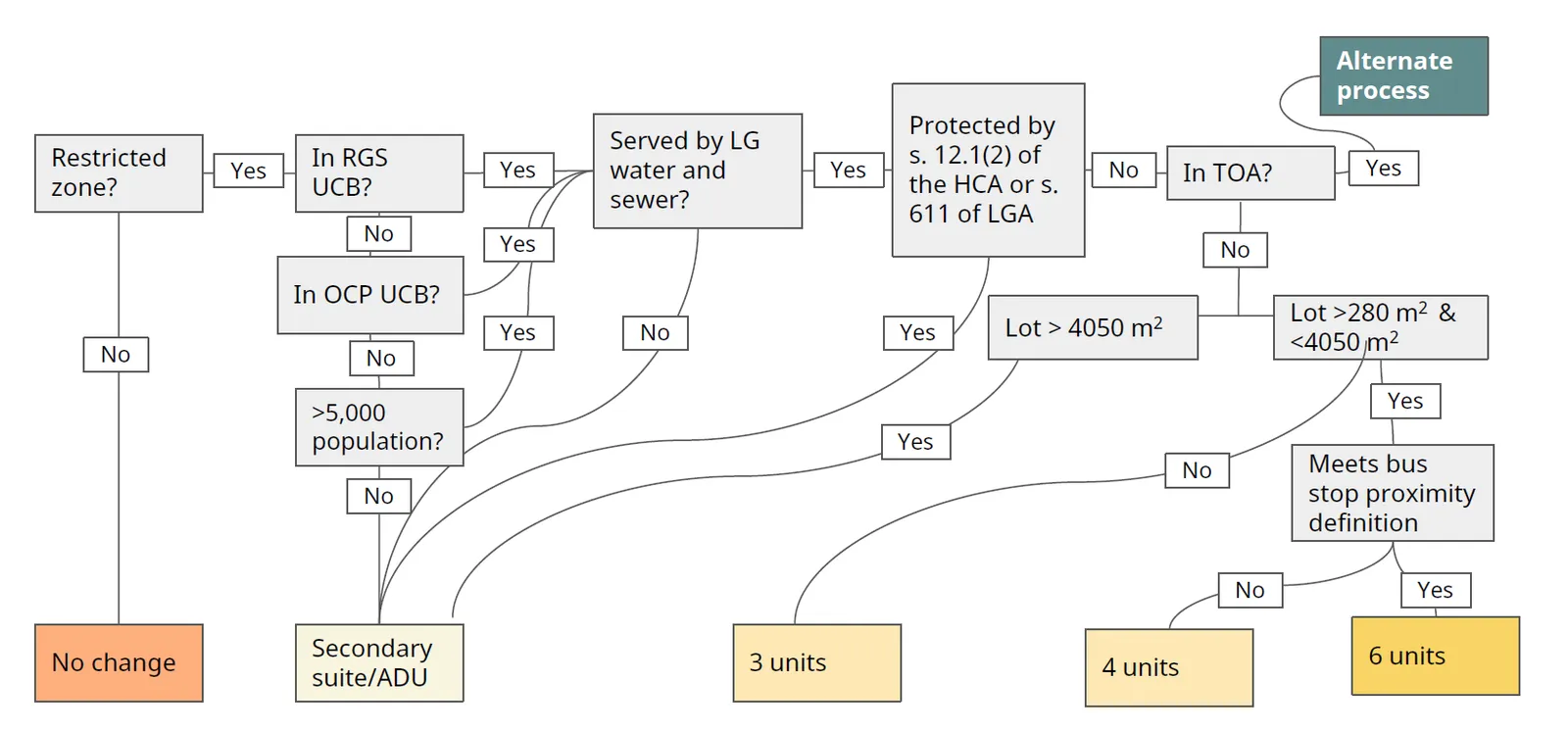
The process is illustrated in Figure 9.
4. Identifying parcels subject to secondary suite and accessory dwelling unit requirements
Unless subject to the higher densities of three to six housing units, and regardless of community size, at least one secondary suite and/or one accessory dwelling unit (ADU) must be allowed on all lots in a Restricted Zone, with the exception of lands in a local trust area or subject to a rural land use bylaw. Local governments should follow these steps to identify the parcels in their jurisdiction for which the SSMUH legislation requires amending bylaws to permit at least one secondary suite and/or one ADU:
a) review the official community plan and local zoning bylaws to identify areas and zones that meet the definition of a Restricted Zone under the SSMUH legislation (see Part 1, Section 1 of this manual on page 7 or information on identifying zones that meet the criteria), b) run a GIS query to identify and isolate (highlight/select) all parcels within¹⁶ those zones that have been determined to meet the definition of a Restricted Zone, c) run a GIS query to identify and isolate (highlight) all parcels identified in step (b) to identify which parcels are not serviced by both water and sewer systems operated by, or on behalf of a local government, d) if ADUs are permitted generally, to identify lots where only secondary suites, not ADUs should be permitted, run a GIS query to identify which parcels identified in step (c) are not serviced by local government sewer systems and are under one hectare in size
Zoning of the highlighted parcels must be amended to permit at least one secondary suite or one accessory dwelling unit in addition to a principal dwelling unit unless the property is less than one hectare in size. On properties that are less than one hectare in size, only secondary suites, and not ADUS, should be permitted. Local governments can then query the number of lots that will be affected by the zoning changes.
¹⁶ “Within”, in this context can mean that a parcel is majority covered by a Restricted Zone. Other concepts of “within” that could be used for the purposes could include: Completely covered by a Restricted Zone; partially covered by a Restricted Zone or has the centre point of the parcel within a Restricted Zone.
5. Identifying lots subject to a minimum of three to six housing units
Except where exempted under the SSMUH legislation, land in Restricted Zones as defined in the legislation that meets the following criteria must be zoned to permit between three and six dwelling units, depending on the size of the lot and proximity to transit: a) the land is wholly or partly within an urban containment boundary established by a regional growth strategy applicable to the municipality or regional district, as the case may be; or b) the land is within a municipality with a population of 5,000 or greater, and is wholly or partly within an urban containment boundary established by an official community plan of the local government; or c) if neither (a) or (b) applies, the land is in a municipality with a population greater than 5,000.
Local governments should follow the steps below to identify the lots in their jurisdictions under which the legislation requires that zoning bylaws be amended to permit three to six dwelling units.
- Review the local zoning bylaw to identify the zones that meet the definition of a Restricted Zone under the SSMUH legislation (see Part 1, Section 1 of this Manual on page 7 or information on identifying zones that meet the criteria);
- Run a GIS query to identify and isolate (highlight) all lots in all zones that have been determined to meet the Restricted Zone definition.
- Run a GIS query to identify and isolate (highlight) all lots identified in step (2) above that are wholly or partly within any of the following: a) an urban containment boundary established by a regional growth strategy applicable to the municipality or regional district, as the case may be; b) an urban containment boundary established by an official community plan of the municipality or regional district as the case may be; or c) a municipality with a population that exceeds 5,000.
At a minimum, all these lots should allow for three or four dwelling units, pending identification of land that is exempt from the legislation as follows: a) land that is protected under section 12.1(2) of the Heritage Conservation Act; b) land that is, on the date this section comes into force, designated as protected under a bylaw made under section 611 [heritage designation protection]; c) land that is not connected to a water or sewer system provided as a service by a municipality or regional district; d) land that is within an area designated as a Transit-Oriented Area; e) land that is within a zone which has a minimum lot size of 4,050m² (or greater) for the purposes of subdivision; and f) a parcel of land that is larger than 4,050 m².
6. Identifying the lots exempt from the minimum three to six housing units requirements
a) Run a GIS query on all highlighted lands within the urban containment boundary to identify all lots protected under Section 12.1(2) of the Heritage Conservation Act. Eliminate these lots. b) On all remaining highlighted lands within the urban containment boundary apply, or create and apply, the GIS layer for properties with a Heritage Designation under LGA section 611 as of the date the SSMUH legislation comes into force.¹⁷ Eliminate these lots. c) On all remaining highlighted lands, apply, or create and apply, the GIS layer for: ● The municipal or regional district water service areas; and ● The municipal or regional district sewer service areas. Eliminate all lots that are outside of one or both service areas.¹⁸ d) On all remaining highlighted lands, run a GIS query to identify all parcels that fall within an area designated as a transit-oriented area as defined in the legislation. Parcels where only a portion of the lot area is within the prescribed distance are considered to be wholly within the area. Eliminate these lots.¹⁹ e) Run a GIS query on all remaining highlighted lands to identify all parcels with a lot area greater than 4,050 m². Remove these lots from consideration.
The remaining highlighted lots upon concluding steps 1 through 4 above are the lots that will require zoning amendments to permit between three (3) and six (6) dwelling units. The next steps will help guide local governments in identifying the parcels where at least three, four, and six units will be required.
¹⁷ Where these lots are not included as a layer within a geographic information system or digital mapping program, they can be identified from local government records and eliminated individually. ¹⁸ Land serviced by improvement district or strata-run water and/or sewer systems is exempt from the three-to-six-unit requirement. Land serviced by on-site water (groundwater well, etc.) or on-site sewer (septic field) is also exempt from the three-to-six-unit requirement. ¹⁹ These will be subject to separate legislation about Transit-Oriented Areas.
7. Determining where zoning must be amended to permit three, four, or six dwelling units
- After concluding steps 1 through 4 above, for all remaining highlighted lots, run a GIS query to identify parcels that are less than 281 m² in area. Zoning of these parcels should be amended to permit up to three (3) dwelling units.²⁰
- For all remaining parcels, identify all bus stops with the prescribed service level and frequency in the highlighted area. A prescribed bus stop meets the following criteria: a. A least one route arrives at the bus stop on average every 15 minutes between the hours of 7 a.m. and 7 p.m. between Monday and Friday b. At least one route arrives at the stop on average every 15 minutes between the hours of 10:00 a.m. and 6:00 p.m. on Saturdays and Sundays.
- Apply, or create and apply, those routes as a layer within the highlighted area.
- Run a GIS query to identify all lots within the highlighted area that fall within 400 metres of a bus stop that meets the specified service level and frequency criteria as measured. Parcels where only a portion of the lot area is within the prescribed distance are considered to be wholly within the area.
- Of those parcels, run a GIS query to identify all parcels greater than 281m² in area. Under the SSMUH legislation, municipalities must amend the zoning of all lots identified through steps 9 to 13 above to permit up to six (6) dwelling units per lot.
- All remaining parcels which are greater than 281 m² and not permitted for six (6) units because they are more than 400 metres from a bus stop of the prescribed service and frequency, must be zoned to permit up to four (4) dwelling units per lot.
²⁰ Local governments may permit density in zoning bylaws beyond that prescribed by the SSMUH legislation.