Appendix E: Calculating incremental build-out density under SSMUH zoning
A framework for local governments to estimate the realistic uptake and phased development of new housing units over a 30-year period.
Appendix E: Calculating incremental build-out density under SSMUH zoning
1. Method 1: Trends assessment
The trends assessment approach is a basic method that uses readily available data to build assumptions about the uptake of SSMUH dwellings under multiple scenarios. The informational basis for this approach is tied to longitudinal information from either the Statistics Canada Census or BC Assessment data, whichever is more readily available. The approach is described below and pictured in Figure 10.
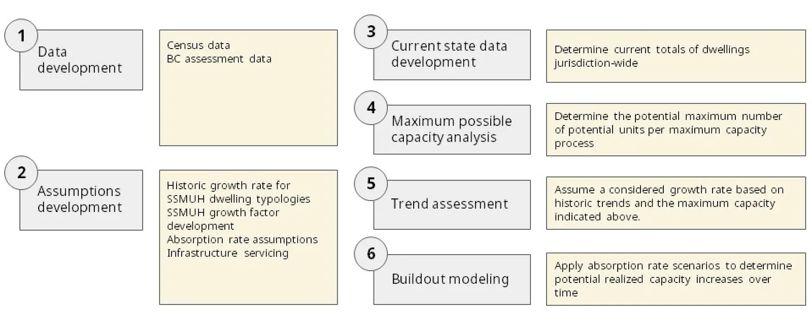
- Data development: detailed information with regards to the growth in dwellings allowable under SSMUH zoning are available from either the Census of Canada or BC Assessment. Each of these datasets can be structured to build assessments in the following ways.
a) Census data Census profiles from 2006, 2016, and 2021^21 can each be accessed from statistics Canada for any given local government. Each of these profiles will contain a report on the quantity of dwellings unit by structural type of dwelling^22. Structural types of dwellings that correspond to SSMUH include: * Semi-detached House -> Duplex can be used as a proxy for a 3- 4- or 6-plex; * Row House -> Can be used as a proxy for a 3- 4- or 6-plex; * Apartment or flat in a duplex -> Can be used as a proxy for a Secondary Suite^23.
Each of these above dwelling types can summarized longitudinally in order to build basic annual absorption rates by SSMUH type.
b) Assessment data BC assessment data contains information on the quantity and type of buildings based on their year of construction. For the purposes of this exercise. it is necessary to discern how many units by type are constructed each year. This can be done by using BC Assessments Actual Use Code (AUC) and the BCA “year built” fields. Pertinent actual use codes will include: * 32 - Residential Dwelling with Suite -> Secondary Suite; * 33 - Duplex, Non-Strata Side-by-Side or Front / Back -> Duplex; * 34 - Duplex, Non-Strata Up / Down -> Duplex; * 35 - Duplex, Strata Side-by-Side -> Duplex; * 36 - Duplex, Strata Front / Back -> Duplex (all of which can be used a proxies for a 3- 4- or 6-plex); * 39 - Row Housing (Single Unit Ownership) -> Can be used a proxy for a 3- 4- or 6-plex; * 41- Duplex, Strata Up / Down 47 -> Can be used a proxy for a 3- 4- or 6-plex; * 48 - Triplex -> 3- 4- or 6-plex; 49 - Fourplex -> 3- 4- or 6-plex; * 52 - Multi-Family (Garden Apartment & Row Housing) -> Can be used a proxy for a 3- 4- or 6-plex; * 53 - Multi-Family (Conversion) -> Can be used a proxy for a 3- 4- or 6-plex.
Similar to the Census method above, each of the above unit types can be summarized from 2006 in order to build basic annual absorption rates by SSMUH types.
Assumptions development: given the data developed above, the following assumptions should be generated: a) Historic absorption rates by SSMUH type -> Summarize SSMUH units and divide by 15 (regardless of method), this is the basic annual absorption rate b) SSMUH growth factor -> a percent modification based on a considered review of market conditions to determine the increase in annual absorption over the baseline rate detailed above. c) Other absorption rate assumptions -> additional constraining factors such permitting times, escalating costs, declining provincial growth that can modify the growth factors detailed above d) Infrastructure and servicing assumptions -> constraining factors as they relate to increased servicing requirements that may mitigate against the development of SSMUHs.
Current state development: based on calculations described above, the current state of units can be used to net out the incremental increase in units based on the trends to be calculated in step five (5) below.
Maximum possible capacity analysis: the maximum unit capacity should be determined to construct a maximum bound for the trend to be calculated in step five (5) below.
Trend assessment: using the information from steps 1 and 2, growth rates should be developed that reflect historic trends and mitigating factors. Growth rates should not exceed the maximum capacity of units in step four (4) nor should they be so extreme as to double or triple the number of units within a 30-year time frame.
Buildout modeling: growth rates should be transformed into annual absorption rates to determine the net annual number of SSMUH units that may be constructed over time. This incremental increase in capacity can be subsequently used to inform infrastructure considerations which are discussed in Part 3, Section 6 of this manual.
^21 The Census changed its definition of dwellings in 2006 which inhibits the use of 2001 for trend analysis. ^22 https://www12.statcan.gc.ca/census-recensement/2021/ref/98-500/001/98-500-x2021001-eng.cfm ^23 Note that detached coach homes are treated as single detached dwellings and are therefore challenging to isolate from that grouping.
2. Method 2: Complex build-out modeling
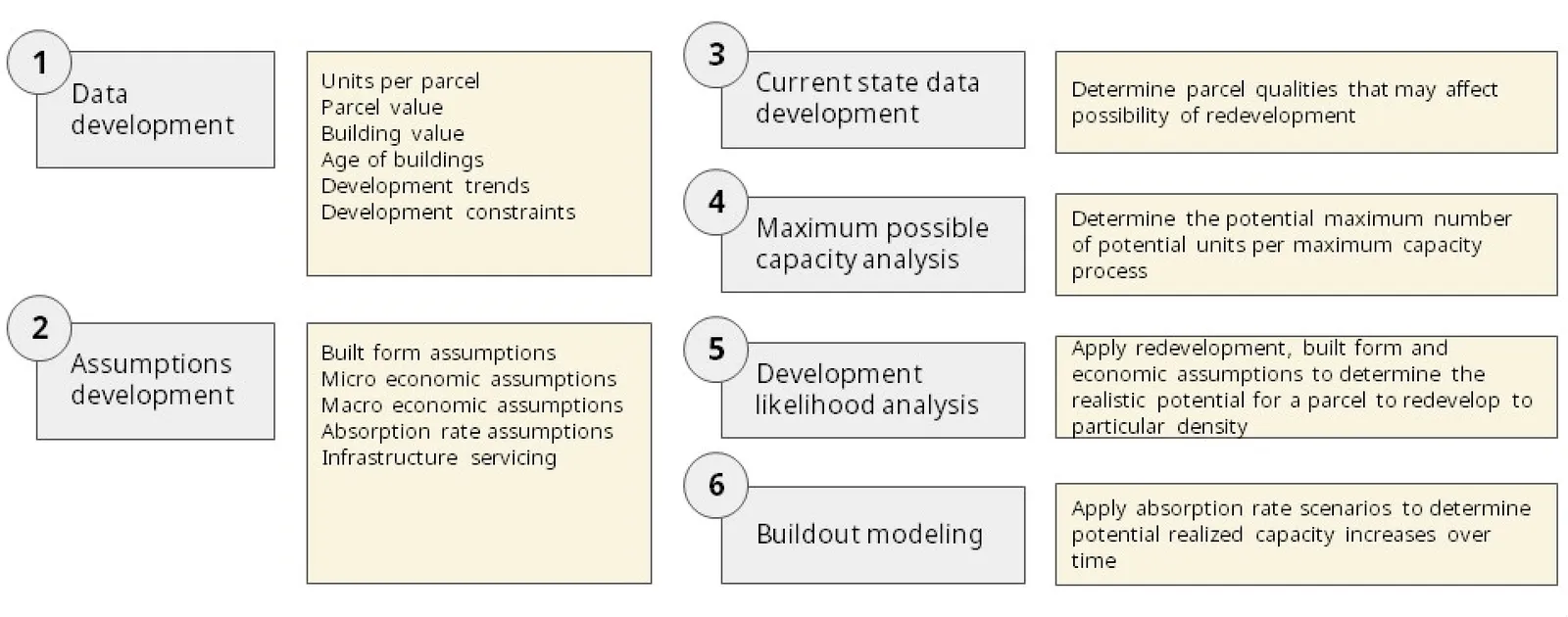
The complex build-out modeling approach is an advanced method that uses readily available data to construct likely development scenarios under current economic conditions. type of approach should be led by a qualified GIS expert in conjunction with a land economist and local government staff, specifically development planners and long-range planners. The effort requires significant levels of data structuring and advanced geospatial and numerical modeling. Despite the complexities of this approach, it will yield highly accurate results which can be used for infrastructure impact analyses and other value-added analyses, as appropriate. The method is illustrated in Figure 11. Each step corresponding to the numbers in the figure is described in detail below.
3. Data development
Data to be considered for this effort should include BCA data, BIR data, as well any information regarding conceptual, proposed or in-progress developments, environmental or infrastructural constraints to development along with local government policies and regulations pertaining to allowable uses, density and built forms. Subsequently, the BCA data should be processed such that a reasonable baseline of buildings in the community can be developed at the parcel scale.
This baseline will include information on the use of each parcel, the assessment classification code and occupancy code of the parcel, the number of units, the construction year of the structures, the total built floor area and the total land and improvement values. In addition, relevant municipal policy information, development permit data and constraints data should be extracted and applied to the parcels. The outcome of this effort will be a fully attributed baseline dataset that presents an up-to-date snapshot of all development considerations in the community at the parcel scale. This data can be used for value-added purposes in any current-state-style assessment. This information will be used to determine the potential for a parcel to redevelop under normal economic conditions (described in Step 3 below).
4. Assumptions development
Given that the SSMUH zoning bylaws will suggest a discrete potential development typology for any given parcel, it is crucial to develop a representative set of modeling archetypes, each of which will act as parametric guidelines in the modeling. The archetypes will have two major components, each of which is detailed below:
a) Built Form Assumptions - these are the design considerations that will guide the minimum parcel size, minimum floor-plate size, density, height, setback, and usage of a particular development. They are crucial for determining economic viability of a potential use as well as the resulting form. The key components are density, coupled with maximum or achievable FARs and setbacks all of which may impact the ultimate built form of the location, the total potential floor area of the development, and the resulting potential hypothetical profit of the development given the input land and construction costs.
b) Development Context Assumptions - these assumptions relate to the contextual milieu by which a particular building type will be permitted. Typically, this forms a table of allowed uses by land use type and local plan area, but occasionally additional overlays are considered, such as development permit areas, location specific locational overrides, or other policy considerations (such as agricultural interface for instance), on a case-by-case basis. Many development context considerations will be overridden by the forthcoming SSMUH zoning implementation under the SSMUH legislation.
Secondly, absorption rate scenarios should be developed. These will be used to determine the cadence of development once redevelopment potential is evaluated. This will require the following efforts: a) analysis of the municipality’s recent development history, b) interviews with municipal staff, c) interviews with local builders and developers, and d) analysis and projections of the region’s relevant labour force.
These inputs will be refined into 2 to 3 scenarios which will define the cadence and volume of development in the community from the near term (3 years from SSMUH implementation under the legislation (it is assumed that projects in the current development pipeline will override any absorption scenario) out to 30 years from SSMUH zoning implementation under the legislation). As these scenarios could have a significant impact on how the community will build out, they should be tested for realism and require both input and sign-off by relevant municipal planning and engineering staff in advance of finalization.
5. Current state development
Using the information developed in Step 1 above, it is imperative to score all qualifying parcels in the community to determine how the urban fabric may change over time based on the SSMUH legislation. This effort is required to add a degree of realism to this incremental build out effort and should be used to evaluate development potential, which reflects a market response to the SSMUH zoning policy, land availability and costs, housing and employment demands, access to transit, as well as locational contexts more generally. The core of this modeling step is to establish a “redevelopment” score for a given location.
To establish development likelihood scores, a modeling team should consider some combination of the six following market factors. Data availability (specifically assessment-based information from BCA) as well as information determined at Steps 1 and 2 should determine which factors are ultimately considered for this effort.
a) Parcel improvement value to land value ratio: This ratio is developed by dividing a parcel’s improvement value by its land value. A parcel with a low improvement-to-land ratio is more likely to be redeveloped. b) Average adjacent parcel improvement value to land value ratio: A parcel with a low improvement-to-land ratio compared to its neighbor’s is more likely to be developed. c) Parcel FAR: Floor area ratio (FAR) is the measure of the built floor area of a parcel divided by the total area of the parcel. A parcel with a low FAR is more likely to be developed. d) Density Gap: This measure evaluates the relative utilization of parcels under current policy. A parcel with a large density gap is more likely to be developed. e) Effective Year: This factor considers renovations and upgrades of a structure which serves as a better metric than year built. Generally, a parcel with an older effective year is more likely to be developed. f) Locational factors: As appropriate for higher SSMUH densities under the legislation, it may be appropriate to allocate an additional locational bonus to reflect favorable milieux for some developments (specifically transit station areas).
Regardless of factors used, the second stage of this step is to reduce or constrain the development potential of a given location using a standard set of constraints (potentially including, but not limited to flood plains, hazardous/complex terrain, potentially contaminated sites, locations of indigenous cultural significance, interface considerations etc.), which should act in three separate ways described below.
- The first should be to reduce the development potential score of some sites on a case-by-case basis with input from the development planners in the community.
- The second application of constraints should be to reduce the functional size of some parcels. This should occur mainly through environmental constraints, encumbrances, and other infrastructure requirement.
- The third should be to remove some parcels from consideration entirely. This should incorporate development planners’ collective knowledge and should be evaluated on a parcel-by-parcel basis and may include rental housing stock retention and/or land ownership, as appropriate.
The final stage of the redevelopment model is to score all parcels based on the net of redevelopment potential and constraints. Scores are typically assigned at a sub-municipal level either by policy context, location context, or some combination thereof. This is done by design since developing a comprehensive municipal score comparing lower value outlying parcels and higher value inner-city parcels does not yield useful information.
6. Maximum possible capacity analysis
As detailed in earlier calculations in Appendix D, the maximum unit capacity should be determined to construct a maximum bound for the trend to be calculated in step five (5) below.
7. Development likelihood analysis
Once the redevelopment potential has been quantified and the development archetypes have been defined, intermediate processing of all parcels in the community should be conducted to determine which SSMUH development archetype would work best on a site-by-site basis. These efforts should include:
a) removal of newly developed, to-be developed, illogical or highly constrained parcels from the model; and b) testing all parcels for qualifying development typologies using built-form, policy, and economics inputs as a guide to identify the most profitable (and/or viable) potential development typologies. For instance, in an area that allows for up to six units, due to increased construction costs, the most profitable development type for this parcel may be a four-plex as opposed to six-plex.
8. Build-out modeling
The result of Steps 1 to 5 above will be a preferred potential development outcome for each parcel in the community that has development potential. Theoretically, this outcome represents the maximum logical capacity of a community absent any considerations with regards to unit absorption rates (i.e., the rate at which units sell in an area in a given time period), permitting speeds, or labour considerations. To refine this maximum capacity into a reasonable sequence of development, it is therefore necessary to apply the absorption rates scenarios as defined in step two (2) above to the preferential development outcomes in step five (5) to develop an annual build-out of the community to 30 years after the implementation of the SSMUH zoning under the legislation.
This effort will result in a numerical build-out that indicates for each qualifying SSMUH-zoned parcel, the potential year of development, the resulting development type, floor area and number of units. These units can subsequently be converted into population or equivalent development units (EDUs) as appropriate for the local government’s needs using agreed-upon multipliers (either from standard BC best practices or using trended municipal data or a combination of both). Summary data can be produced for milestone years, as appropriate, and should be accompanied by maps and graphs, as appropriate, for rapid review and iteration.
The technical work should be finalized based on clear acceptance criteria from a local government that should be developed during project initiation. Specific criteria could include, but may not be limited to:
a) Accuracy - Does the build-out reflect the policy input parameters of the modeling? Do the buildouts indicate a smooth development cadence that mirrors historic trends? b) Realism - Does the build-out reflect the experience of municipal staff with respect to historic development in the community? c) Plausibility - Does the build-out portray development outcomes that seem achievable under current or forecast economic conditions? d) Spatial Distribution - Does the build-out indicate a spatial pattern of development that reflects the intents of municipal planners?