Staff Report: OCP Amendment Application 2017/01 and Rezoning Application 2017/02 – 1938 West Park Lane
Report evaluating the redevelopment of Thetis Lake Campground into a multi-family residential complex with 350 units.
TOWN OF VIEW ROYAL Council Report
TO: Mayor and Council FROM: J. Chow, Senior Planner DATE: June 29, 2017 MEETING: July 4, 2017 FILE NO.: 3440-20-2017/01, 3360-20-2017/02
OFFICIAL COMMUNITY PLAN AMENDMENT APPLICATION 2017/01 AND REZONING APPLICATION 2017/02 – Bylaws for 1938 West Park Lane
RECOMMENDATION:
THAT the June 29, 2017 report from the Senior Planner titled “Official Community Plan Amendment Application 2017/01 and Rezoning Application 2017/02 - Bylaws for 1938 West Park Lane” be received;
AND THAT, having considered appropriate consultation, both early and ongoing, with various persons, organizations and authorities considered to be potentially affected, in consideration of and compliance with the Local Government Act, staff be directed to email a copy of Official Community Plan Bylaw No. 811, 2011 Amendment Bylaw No. 978, 2017 to BC Hydro, BC Ministry of Transportation and Infrastructure, BC Transit, Canada Post, Capital Regional District, Esquimalt First Nation, FortisBC, School District No.61, Shaw Cable, Songhees First Nation, and Telus;
AND THAT coincident with final reading of Zoning Bylaw No. 900, 2014 Amendment Bylaw No. 979, 2017, a covenant be registered on the lands to require the following: a. Transfer of ownership of Lot A, Plan EPP55974 to the Town by December 31, 2018; b. Prior to issuance of any building permit on the subject property:
- approval of detailed civil engineering plans (the works) by the Director of Engineering for an asphalt walkway with concrete curb on West Park Lane and a concrete curb and sidewalk on Six Mile Road north of Trans Canada Highway; and
- either completion of the works or a security deposit of 120% construction cost; and
AND FURTHER THAT a Public Hearing be scheduled for July 18, 2017 for the two bylaws.
CHIEF ADMINISTRATIVE OFFICER’S COMMENTS:
I concur with the recommendation.
DIRECTOR OF DEVELOPMENT SERVICES’ COMMENTS:
I concur with the recommendation.
DIRECTOR OF ENGINEERING’S COMMENTS:
I concur with the recommendation.
DIRECTOR OF PROTECTIVE SERVICE’S COMMENTS:
I concur with the recommendation.
PURPOSE:
- To introduce the following bylaws for first and second reading:
- Official Community Plan No. 811, 2011 Amendment Bylaw No. 978, 2017
- Zoning Bylaw No. 900, 2014 Amendment Bylaw No. 979, 2017
- To provide recommendations for bylaw referral, securing community amenity contributions, and setting a public hearing date.
BACKGROUND:
The triangular 5.18 ha parcel is located north of Trans Canada Highway and backs on to Thetis Lake Regional Park as shown in Attachment 1. Access is from West Park Lane on the east. The west half of the site is primarily hilly, forested terrain with a rocky hilltop to the north. Thetis Lake Campground and Trailer Park has been operating for decades on the east half of the property. There are some residents living full time in manufactured homes on the site (not a permitted use in the C-6: Tourist Commercial (Campground) zone). The owners of the campground are now winding down the operation.
The redevelopment of this parcel is a significant objective pursued by the Town of View Royal since 2015. The Town’s strategic plan for the period 2015 to 2018 included various action items to affect this transition.
Rezoning application 2016/04 was presented to Committee of the Whole on February 14, 2017 to rezone the parcel for 45 single family residential lots, 14 townhouse units on three multifamily lots, a 15,494 m² natural area and 378 m² neighbourhood park.
April 11, 2017 minutes indicate that Limona Construction gave a presentation to the Committee regarding a new development concept for 1938 West Park Lane and 200 Cheam Road. They described the opportunity to rezone 1938 West Park Lane for apartment and townhouse use and not develop 200 Cheam Road (now Lund Road – see Attachment 3), eliminating the plan to remove trees and terraform that currently undeveloped property. Instead, 200 Cheam Road would remain undeveloped.
Concept drawings for 1938 West Park Lane were provided that showed four multi-family buildings of five storeys in height (240 units), as well as forty-six townhomes. The drawings indicated that parking for the multi-family buildings would be underground and that 56% of the site would remain as greenspace. The Committee discussed density; absorption rates; visibility from the Trans-Canada Highway; tenure; the applicant’s proposition for gated access; and traffic impacts. It was noted that there may be a need for a roundabout at Atkins Road and Six Mile Road. The updated applications were introduced at the June 13, 2017 Committee of the Whole meeting.
PROPOSAL:
Official Community Plan No. 811, 2011 Amendment Bylaw No. 978, 2017
- Change the land use designation from “Parks Recreation, Open Space” to “Mixed Residential”.
- Include the parcel in the Mixed Residential Development Permit Area to enable regulation of the form and character of multiple family residential developments.
- Include the parcel in the Sensitive Terrestrial Ecosystems Development Permit Area to address the natural environment, wildland/urban interface and steep slopes.
Zoning Bylaw No. 900, 2014 Amendment Bylaw No. 979, 2017
- Rezone the site from C-6: Tourist Commercial (Campground) to a new CD-23: Comprehensive Development (Thetis Lake) zone for multi family residential use. The zone would permit up to 350 units in apartment buildings (maximum five storeys) and townhouses and duplexes (up to 2.5 storeys).
Development Concept
The applicant’s development concept is for up to 350 residential units (Attachment 4). Submitted plans (Attachments 5 and 6) show 306 multifamily units comprised of the following:
- Two 70-unit apartment buildings with five storeys and underground parking
- Two 60-unit apartment buildings with five storeys and underground parking
- 46 townhouse/duplex units
The applicant provided the plans for discussion purposes only because they anticipate shifting the location of townhouses away from the west half of the property to reduce servicing cost costs due to the slope and the amount of blasting that would be required. The apartment buildings are not expected to change location significantly as they were laid out by the project architect to work with the topography but the number of units may change depending on market demand for one bedroom apartment units versus two or more bedroom units.
The concept includes subdividing the parcel into five lots so development can be phased (Attachments 7 and 8). Four apartment buildings would each be on a separate lot, with cross access easements and rights of way to connect with West Park Lane through the townhouse/duplex lot. If the bylaw amendment applications are approved, development permits will be required for subdivision, for regulation of form character, and to address the natural environment, wildland/urban fire interface, and steep slopes.
The applicant has provided the following studies evaluating the development concept:
- Traffic Impact Assessment (Attachment 9)
- Wildland-Urban Interface Fire Hazard Assessment (Attachment 10)
- Storm Water Management Concept
Community Amenity Contribution
The applicant offers the following:
- Transfer of a 5.12 ha forested parcel at 200 Cheam Road (now Lund Road - see Attachment 3) to the Town. The parcel is designated Rural in the Official Community Plan and is zoned A-1 (Rural). The parcel is offered as is, with no proposed change to the land use designation or the zoning. If transfer of ownership is not possible, the applicant will provide $2.5 million to the Town before any building permits are issued
- Pedestrian infrastructure improvements on West Park lane and Six Mile Road north of Trans Canada Highway
DISCUSSION:
Relevant issues include the following:
- Policy implications
- Official Community Plan amendment consultation
- Potential land use impacts
- Community amenity contributions
- Public Hearing date
1. Policy Considerations
The redevelopment of this parcel is a significant objective supported by the Town of View Royal since 2015. The Town’s strategic plan for the period 2015 to 2018 included various action items to affect this transition. The proposal would be in accordance Town’s and Regional District’s overarching goals of focusing density to reduce sprawl and protect natural/rural areas outside the Urban Growth Boundary.
Relevant Official Community Plan policies for rezoning include the following:
Policy LU1.4 Diversity of Forms and Uses Support a variety of residential and commercial forms and uses to encourage socio-economic diversity, and provide for the diverse needs of youth, families and an aging population.
- The proposal would provide apartment and townhouse style dwellings suitable for younger and older residents where the nearby residential neighbourhoods, aside from the Lakeside Village comprehensive development, are predominantly made up of single family dwellings.
Policy LU2.2 Connected Neighbourhoods Strengthen connections between existing residential neighbourhoods and the mixed-use centres through transportation, urban design and public space improvements, to the effect that neighbourhoods identify with one or more of the mixed-use centres.
- Pedestrian and bicycling facilities on Six Mile Road to should be improved to integrate the neighbourhoods on both sides of the Trans Canada Highway and reduce dependence on automobile use.
Policy LU5.2 Sustainable Development Patterns Direct new growth away from environmentally sensitive areas, and promote sustainable development patterns and building forms that result in a more efficient use of limited land.
- The majority of buildings are proposed to be sited on the east half of the site. The west part of the site is rocky and more natural features can be retained.
Policy LU5.4 Urban Growth Boundary Maintain the Urban Growth Boundary (UGB) and continue to direct new urban development and improvements within the boundary.
- The site is within the Urban Growth Boundary.
Policy LU5.6 Parkland Support the acquisition, development and enhancement of parkland as a means of protecting the natural environment and providing important social space.
- The proposed community amenity contribution would protect 5.12 ha of forested land.
Policy LU5.7 Parkland and Open Space Integration Promote the integration of parkland, open space and natural features into the built environment.
- Green space within the subject property would provide a transition to the adjoining park. The community amenity contribution of 5.12 ha forest land at Lund Road would be a significant public asset.
Policy TR1.2 Pedestrian Improvements Enhance pedestrian access and movement through the development of a system of sidewalks, multi-use trails and pedestrian paths integrated with public transit in all areas. Improvements should be carried out according the Transportation Master Plan.
- The 2007 Transportation Master Plan supports sidewalks on both sides of Six Mile Road north of the Trans Canada Highway where there is currently a sidewalk on one side ends before West Park Lane. This area is beyond the frontage of the development site.
Policy TR1.3 Cycling Infrastructure Promote cycling for commuting, personal transport and recreation purposes through improvements to infrastructure and facilities as identified in the Transportation Master Plan. The inclusion of bicycle parking areas and facilities such as showers, lockers, and change rooms shall be encouraged at commercial, institutional, public, recreational, and multi-family residential development sites.
- The 2007 Transportation Master Plan supports bicycle lanes on Six Mile Road, which is beyond the frontage of the development site but is the only access to it.
Policy TR3.1 Transportation Master Plan Support the safe and efficient movement of vehicles, cyclists and pedestrians throughout View Royal in accordance with the priorities and strategies established in the Transportation Master Plan.
- While the traffic generated by this development would not be significant, there is existing rush hour vehicle congestion at the south end of Six Mile Road that is not expected to improve over time due to regional traffic volume.
2. Official Community Plan Amendment Bylaw consultation
When an OCP amendment is being considered, s. 475 of the Local Government Act requires local governments to provide one or more opportunities it considers appropriate for consultation with persons, organizations and authorities it considers will be affected. The local government must:
a. consider whether the opportunities for consultation with one or more of the persons, organizations and authorities should be early and ongoing, and b. specifically consider whether consultation is required with i. the board of the regional district in which the area covered by the plan is located, in the case of a municipal official community plan, ii. the board of any regional district that is adjacent to the area covered by the plan, iii. the council of any municipality that is adjacent to the area covered by the plan, iv. First Nations, v. school district boards, greater boards and improvement district boards, and vi. the provincial and federal governments and their agencies.
Staff notes that the notice of public hearing and the public hearing itself are considered an opportunity for public consultation. Although the proposed OCP amendment is considered to be minor, staff can provide email notice of the bylaw to referral groups and agencies. A Council resolution would be required, and is included in the report recommendations.
3. Potential Land Use Impacts
The change in land use has potential offsite impacts that include the following: a. Traffic b. Wildland-Urban Interface Hazard c. Storm Water Management
Following discussion at the Committee of the Whole, it was determined that other site related impacts such as environmental assessment of plant or animal habitat, tree information, and visual impacts can be addressed through a development permit application following rezoning.
a. Traffic
The Traffic Impact Assessment (TIA) (Attachment 9) makes the following conclusions:
“The proposed development will have almost no impact (less than 1 second of additional delay) on Six Mile Road at the interchange ramps and West Park Lane. In 2025, the intersection of Chilco Road/Six Mile Road/Nursery Hill Drive operates at an acceptable LOS during the AM peak period; however, in the PM peak hour the side street turns will operate at a LOS E (for one to two hours per day). In the longer term, if traffic continues to grow at 2.5% in the area vehicles the side street movements on Nursery Hill Drive and Chilco Road will drop to a LOS F during the AM and PM peak hours. The Town may want to consider planning for future separate turn lanes on Nursery Hill Drive and Chilco Road to improve the through/right LOS.
The Atkins Road/Six Mile Road will be required to be a roundabout by 2022 due to background growth on Atkins Road and Six Mile Road. Without the roundabout the Atkins Road movements will continue to drop to poor conditions. The implementation of the roundabout will improve the operations of the existing traffic. The roundabout has significant capacity and will be able to handle the addition of the development traffic without any issues or need for modifications.
The addition of the development will add a minor amount of additional delay at Six Mile Road/Island Highway; however, there will be movements that operate at poor conditions and have long queues due to the existing/background traffic volumes on the network. This is due to the highway volumes using Island Highway and not related to the development traffic.
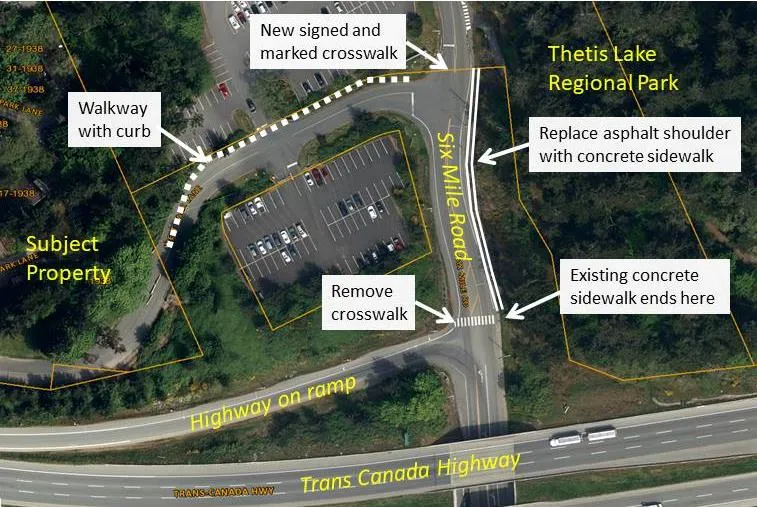
The east sidewalk on Six Mile Road that currently ends at the on-ramp intersection should be extended to the Park boundary. A paved shoulder, with an extruded asphalt curb to separate the shoulder from the road, should be provided from the site to Six Mile Road to improve pedestrian connectivity between the site and Six Mile Road. It is recommended that this separated (by asphalt curb) shoulder be on the north side of West Park Lane. The existing crosswalk at the onramp is less than 100m from West Park Lane. Crosswalks are recommended to be 100 to 200m apart to ensure compliance for motorists to obey signage. Therefore it is recommended that this crosswalk be removed and a new signed and marked crosswalk be located on the north side of the West Park Lane / Six Mile Road intersection.
Cyclists can be safely accommodated on Six Mile Road due to the low volume of traffic [Staff note: north of Trans Canada Highway].
There is no existing transit service within 700m of the site except for the summer months when the #53 provides service to the Park. Expanded transit service is not planned for this area, even with the addition of this development.”
The report recommends a number of road improvements that the Town should undertake to address long term growing automobile congestion in the Six Mile Road area due to increasing regional traffic volume that is expected over the next twenty years whether this development occurs or not. Left turn movements onto Six Mile Road are expected to become more challenging over time.
The report recommends that the applicant provide pedestrian infrastructure improvements on West Park Lane and Six Mile Road as shown in Figure 1. It is recommended that the provision of these improvements be secured in a covenant. Staff recommends that the walkway and sidewalk have concrete curbs for greater durability and lower maintenance costs.
b. Wildland-Urban Interface Hazard
The Wildland-Urban Interface Hazard assessment (Attachment 11) indicates this area has a higher potential risk for fire caused by human activity in the park. Each of the five methods of analysis in the report indicates the fire risk level would change from high to moderate after development if there is fuel management around structures. To reduce wildfire threat, the assessment provides recommendations on precautions during land clearing and construction, vegetation management, construction options, access, Fireflow, and regulatory provisions. The applicant has used this information to establish proposed setbacks. If the bylaws are approved, a development permit application will be required to ensure the finalized site design will address the guidelines.
c. Storm Water Management
Staff has reviewed a submitted storm water management study indicates that the net increase in storm water runoff would be three times the current flow but that there is adequate downstream capacity. On site treatment would consist of traps to remove floating debris and granular materials. Secondary treatment would be provided offsite in a wet area near Trans Canada Highway. Staff is concerned that the increased flow is contrary to Official Community Plan Policy NE2.7 Stormwater Discharge and would accelerate the maintenance requirements of the offsite drainage area on public land. The report indicates the site is steep and rocky, but at the development permit stage staff would like further investigation into options for onsite detention and for infiltration in accordance with the policy, which is as follows:
Policy NE2.7 Stormwater Discharge Ensure that the discharge of stormwater does not negatively impact adjacent water quality and that there is no increase in stormwater discharges as a result of new development. Encourage innovative design techniques that maximize groundwater recharge.
4. Community Amenity Contribution and Budget Implications
The principles of Official Community Plan Policy LU1.6 “Community Amenities” encourage the provision of community and neighbourhood amenities associated with new development. Rezoning is the only time at which offsite improvements beyond frontage improvements can be requested or required. Community amenity contributions are usually offered by a development proponent through negotiation with the local government. If the contributions are not provided by the fourth reading of a rezoning bylaw, they are typically secured in a covenant at that time.
The applicant is offering a 5.12 ha forested parcel on Lund Road (see Attachment 3), which would preserve a significant green space that is almost the same size as the 5.18 ha development site. This parcel is located across the Trans Canada Highway from the subject property and comprises part of Mill Hill, abutting Mill Hill Regional Park.
Securing the property at Lund Road would preserve the east face of Mill Hill, which has high visibility from the Trans Canada Highway; however, Town budget implications of acquiring more land would include additional costs for maintenance and fire prevention. The site has a history of unauthorized camping that would need to be addressed. The applicant does not wish to amend the Official Community Plan “Rural” land use designation or A-1 Rural zoning as the part of the current development proposal, so that would be an expense for the Town.
The Town could consult with the Capital Regional District for interest in incorporating the land into Mill Hill Regional Park. This is not unprecedented; in 2015, the CRD received a transfer of 15.6 hectares of park as a community amenity contribution arising from a rezoning in the District of Highlands.
The applicant proposes to transfer the land to the Town by the end of 2018, and would secure the commitment in a covenant. The covenant will include commitment to provide $2.5 million to the Town in case the transaction does not complete.
CONCLUSION:
The proposal meets the Town’s Official Community Plan objective of focusing density to reduce sprawl and protect natural/rural areas outside the Urban Growth Boundary.
The rezoning application for the site represents the first step in redeveloping this property in line with the Official Community Plan. The rezoning addresses the fundamental issues of use and density. If the application is ultimately approved, future Development Permit applications will address the details of form and character, building materials, fenestration, lighting, landscaping, environmental restoration and protection, tree protection, wildland urban interface fire hazard, steep slope hazards, and parking.
Staff supports encouraging the applicant to volunteer an additional contribution towards the construction of a roundabout at the Six Mile Road /. Atkins Road intersection and this is reflected in the report recommendation for Council’s consideration.
RECOMMENDATION:
THAT the June 29, 2017 report from the Senior Planner titled “Official Community Plan Amendment Application 2017/01 and Rezoning Application 2017/02 - Bylaws for 1938 West Park Lane” be received;
AND THAT, having considered appropriate consultation, both early and ongoing, with various persons, organizations and authorities considered to be potentially affected, in consideration of and compliance with the Local Government Act, staff be directed to email a copy of Official Community Plan Bylaw No. 811, 2011 Amendment Bylaw No. 978, 2017 to BC Hydro, BC Ministry of Transportation and Infrastructure, BC Transit, Canada Post, Capital Regional District, Esquimalt First Nation, FortisBC, School District No.61, Shaw Cable, Songhees First Nation, and Telus;
AND THAT coincident with final reading of Zoning Bylaw No. 900, 2014 Amendment Bylaw No. 979, 2017, a covenant be registered on the lands to secure the following: a. Transfer of ownership of Lot A, Plan EPP55974 to the Town by December 31, 2018; b. Prior to issuance of any building permit on the subject property:
- approval of detailed civil engineering plans (the works) by the Director of Engineering for an asphalt walkway with concrete curb on West Park Lane and a concrete curb and sidewalk on Six Mile Road north of Trans Canada highway; and
- either completion of the works or a security deposit of 120% construction cost; and
AND FURTHER THAT a Public Hearing be scheduled for July 18, 2017 for the two bylaws.
SUBMITTED BY: Jeff Chow, MCIP, RPP Senior Planner
REVIEWED BY: Lindsay Chase, MCIP, RPP Director of Development Services
ATTACHMENTS
- Location plan – subject property
- Subject property air photo
- Location Plan – Lund Road property
- Letter from Applicant
- Thetis Lake Residential Conceptual Site Plan- Wensley Architecture
- Thetis Lake Residential Project Statistics - Wensley Architecture
- Thetis Lake Residential Development (subdivision concept) - Mullin DeMeo Barristers and Solicitors, May 23, 2017
- Proposed Development Plan - Island Land Surveying, May 23, 2017
- Traffic Impact Assessment – Watt Consulting, June 26, 2017 (32 pages)
- Wildland-Urban Interface Hazard Assessment– Strathcona Forestry Consulting, April 28, 2017/June 1, 2016 (19 pages)
Document Images
(4)