TOWN OF VIEW ROYAL COMMITTEE OF THE WHOLE REPORT - REZONING – 2951 CRAIGOWAN ROAD (CHRISTIE POINT)
A background staff report detailing the site context, Official Community Plan alignment, and environmental considerations for the Christie Point rezoning application.
TOWN OF VIEW ROYAL COMMITTEE OF THE WHOLE REPORT
TO: Committee of the Whole FROM: J. Davison, MCIP Planner DATE: February 8, 2017 MEETING DATE: February 15, 2017 FILE NO.: 3360-20-2016-05
REZONING – 2951 CRAIGOWAN ROAD (CHRISTIE POINT)
RECOMMENDATION
THAT Committee receive this report for information.
CHIEF ADMINISTRATIVE OFFICER’S COMMENTS
I concur with the recommendation.
DIRECTOR OF DEVELOPMENT SERVICES’ COMMENTS
I concur with the recommendation.
DIRECTOR OF ENGINEERING’S COMMENTS
I concur with the recommendation.
DIRECTOR OF PROTECTIVE SERVICES’ COMMENTS
I concur with the recommendation.
PURPOSE OF REPORT
The purpose of this report is to present the application for the rezoning of the Christie Point property at 2951 Craigowan Rd.
BACKGROUND
Site Context
Christie Point is a 15.8-acre peninsula extending into Portage Inlet. The site is zoned RM-1: Ground-Oriented Multiple-Unit Residential within Zoning Bylaw No. 900, 2014. The zone permits a range of residential uses from detached residential to townhouse residential, at a maximum building height of 7.5m and a base density of 0.6 Floor Space Ratio (FSR).
The site is on Craigowan Road, which is accessed via Shoreline Drive, and in turn via Island Highway. An alternative transportation option exists in the E&N Rail Trail a short distance to the west. The site is close to Shoreline Middle School and detached residential properties along Shoreline Drive to the south.
161 market rental units are sited on the property in the following configurations:
- 103 2-bedroom apartment units (840 sq. ft.)
- 10 3-bedroom apartment units (1,020 sq. ft.)
- 48 3-bedroom townhouse units (1,135 sq. ft.)
There are no non-market units on the site.
The existing use and siting of the buildings are lawfully non-conforming to the existing zoning and to the general regulations contained within Zoning Bylaw No. 900, 2014 in the following ways:
- Apartment units are not permitted in the current RM-1 zoning.
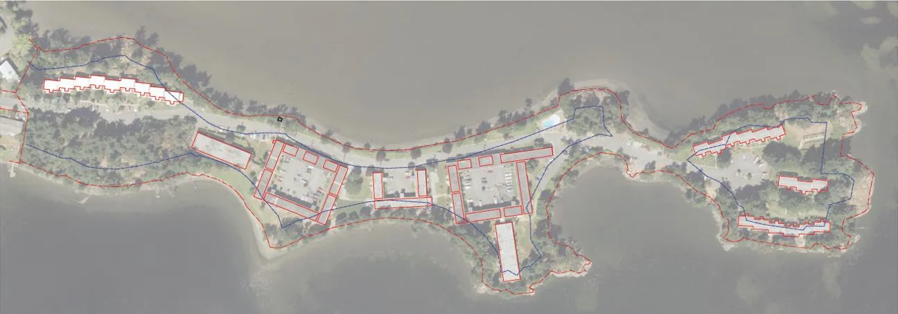
- Most of the buildings are partly within the 15m setback to the natural boundary to the sea (as per the below illustration with the existing building footprints in red and the setback in blue):
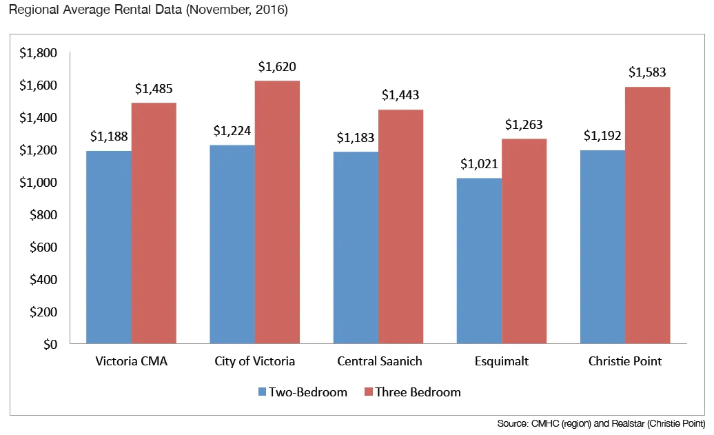
The units are rented at an average rental rate of $1,192 for a 2-bedroom unit (minimum of $923 and maximum of $1,350) and $1,583 for 3 bedroom and townhouse units (minimum of $1,247 and maximum of $1,850). This is comparable with regional market rental rates, as per the figure below:
The buildings on the property are reaching the end of their serviceable use and the applicant wishes to redevelop the site.
Official Community Plan Context
The Town of View Royal Official Community Plan Bylaw No. 811, 2011 designates the site as M-R: Mixed Residential which is described as:
Small lot detached houses, townhouses and low-rise apartments up to 3 storeys and 1.25 FSR, and up to 4 storeys and 1.6 FSR for apartment dwellings.
The site is currently within three Development Permit (DP) Areas as described and regulated within the Town of View Royal Official Community Plan Bylaw No. 811, 2011.
Two DP Areas protect the natural environment:
- Sensitive Terrestrial Ecosystem (across the entire site)
- Natural Watercourse and Shoreline Areas (15m above and below the average high water mark or ‘natural boundary’)
One DP Area regulates the form and character of multi-family residential development, which includes building and landscaping design and materials:
- Mixed Residential Form and Character (across entire site)
PROJECT INFORMATION
The rezoning application proposes a development consisting of 473 townhouse and apartment rental units at a density of 1.15 FSR. This is consistent with the Mixed Residential Land Use Designation within the Official Community Plan (OCP). No OCP amendment is required as part of the application.
The Rezoning Process
An application to rezone a property evaluates the appropriateness of the proposed use and density of the site in the context of on and off-site issues. In considering approval, Council weighs the balance of potential drawbacks with potential benefits of the development for View Royal.
This rezoning proposal is not finalized. This report provides a summary of the existing proposal, and identifies where further work is required. After the Committee of the Whole meeting, staff will work with the applicant to finalize the bylaws and other items required before the application comes forward again to Council for bylaw readings and a Public Hearing.
The application (should it be successful) results in an amendment to the Zoning Bylaw, accomplishing two main things:
- The creation of a new zone; and
- The rezoning of the Christie Point property to that zone.
A Comprehensive Development (CD) Zone is recommended by staff for two reasons:
- There is no existing zone which addresses the specific height, use and density described in the application.
- A CD zone affords Council the greatest amount of control over the zoning and the resulting future development of the site.
While there is a great amount of detail presented in the application, the rezoning process is one step in several which must be undertaken by the applicant to permit the development of the site. There are issues the rezoning can address, and issues that will be considered at Development Permit.
The rezoning process can address:
- Permitted uses
- Permitted densities
- Maximum lot coverage
- Maximum percentage of impermeable surfaces
- Setbacks to property lines that are not from the natural boundary
- Height of buildings
- Size, height and setbacks of accessory structures
- Minimum flood construction level
- Certain conditions of use of the property
The rezoning process cannot address:
- The vehicle or bicycle parking space provision requirements
- The 15m setback to the natural boundary of the sea
- The mechanism by which grade or height of buildings are calculated
- The Development Permit guideline requirements, including architectural styles and environmental protection requirements
- Any regulation contained within the General Regulations in Zoning Bylaw No. 900, 2014
Should the proposal advance to Development Permit stage there may be changes to the proposal and the Development Permit applications will likely contain variances to the zoning regulations within the Zoning Bylaw. This is typical of an application of this size, and is not due to a failure to recognise or adhere to these regulations during the rezoning process. Rather, variances and other changes to the application will address more detailed issues on-site which were not able to be considered at the time of rezoning. The expected variances will be discussed in more detail later in the report.
Proposed Uses
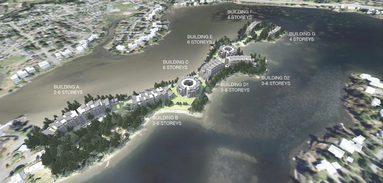
The proposed principal uses for the site are apartment residential and townhouse residential units. The proposal is for rental-only units, which will require a Housing Agreement to secure (this is discussed in more detail later in the report). The proposed height of the buildings is 2 to 6 storeys in eight buildings as illustrated below. The height will be expressed in metres rather than storeys when the zone table is finalized, currently calculated as a maximum of 26m.
Proposed Density
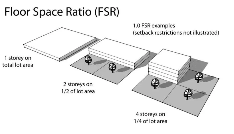
The density on the site is expressed in terms of Floor Space Ratio (FSR). Floor Space Ratio is the ratio between the area of the site and the area of the finished floor space on the property. The concept is illustrated below.
The existing RM-1 zone has a maximum base density of 0.6 FSR, up to a possible 0.8 FSR with the provision of density bonusing items:
- 0.1 bonus FSR for the provision of 80% underground parking
- 0.1 bonus FSR for the provision of 75% green roofs
The Mixed Residential land use designation within the Official Community Plan prescribes up to 1.25 FSR for townhouse use and up to 1.6 FSR for apartment use.
The proposed FSR for the site is 1.15, with no provision for density bonusing. Staff recommends 1.15 FSR as the maximum density in the zone. Density bonusing is not recommended by staff as the proposed density accommodates the proposed development and no further density is requested or anticipated.
Setbacks from Lot Lines
As most the site is adjacent to the natural boundary to the sea, most of the site cannot be regulated by the setbacks within the zone. It is instead subject to the 15m special setback to the natural boundary to the sea, which cannot be changed by the rezoning process. The regulation is specified within Section 3.8.2.a of the Special Setbacks section of Zoning Bylaw No. 900, 2014:
3.8.2. No building, mobile home, recreational vehicle, or fence, retaining wall or other structure, nor any part thereof, can be constructed, moved, extended or located: a) within 15m from the natural boundary of the sea;
The 15m setback covers the same areas above the natural boundary as the Natural Watercourse and Shoreline Environmental Development Permit Area.
An expected variance at the Development Permit stage will be to the 15m setback, as there are several places where the proposed buildings project into it. The existing buildings are, in some places, within the 15m setback requirement as they were built before that regulation was in place. The least impactful measure is to design the new buildings to be within the existing building footprints where possible. This will minimize the impact on trees and natural areas on the site.
Building Height
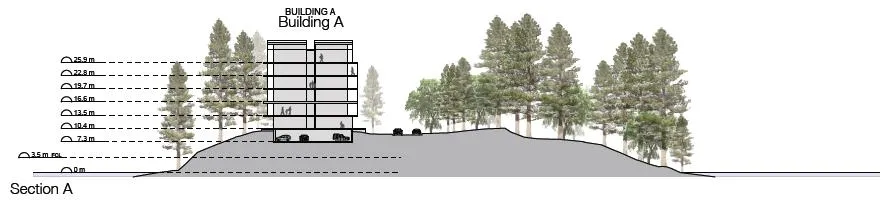
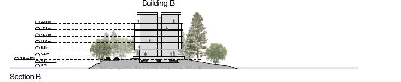
The height of a building is calculated from the average grade across a building footprint. The calculation of grade is defined within the Zoning Bylaw and is based on the lower of natural or finished grade at each significant point on a building. The applicant has provided cross-sections of the buildings as part of the application and illustrated below:
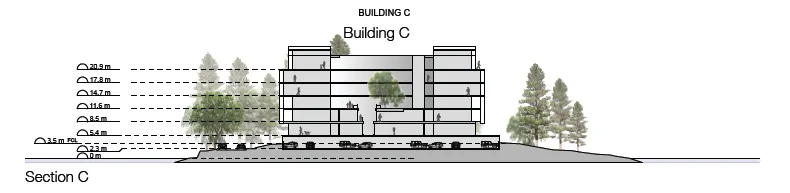
Increasing building height is the only way to add density on the site if most of the development utilizes the existing building footprints.
Building height is, in part, impacted by the demands of sea level rise and the necessary establishment of a minimum flood construction geodetic elevation of 3.5m as recommended by the geotechnical engineer’s report (attached). Staff recommends that the 3.5m elevation for habitable areas and 3m elevation for parkade entrances are established within the zone table.
A potential (but not certain) variance at time of Development Permit is to the height of the buildings described within the zone. While the applicant and staff will work together to ensure that the heights proposed in the zone will be the heights at the time of Development Permit, changes in finished grade or changes in building design can impact the final requested heights.
Visual Impact
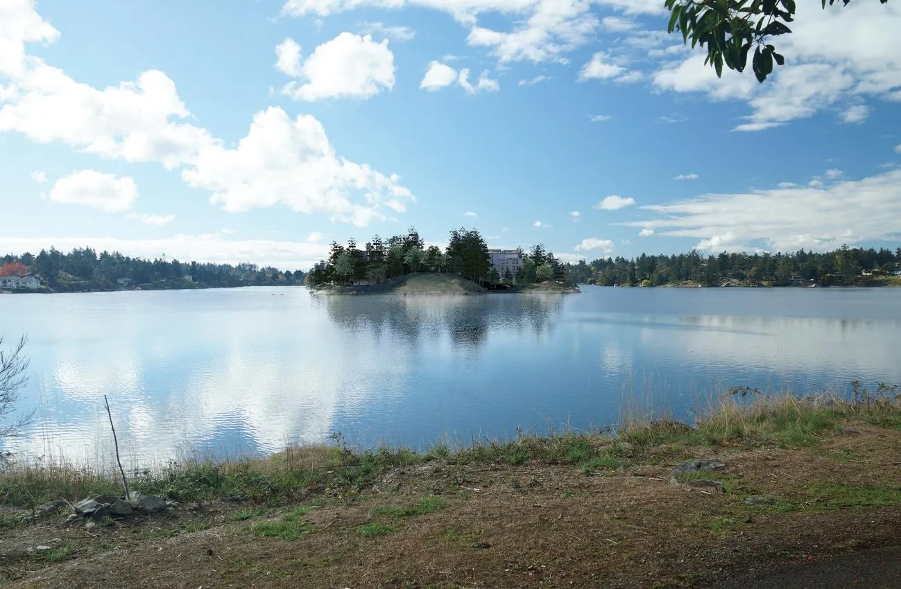
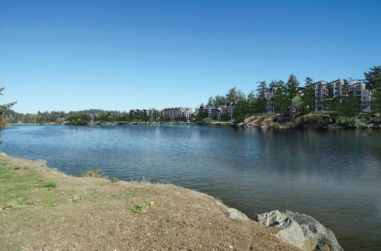
A side-effect of building height is visual impact. The applicant has provided renderings to show how the development may appear from several vantage points:
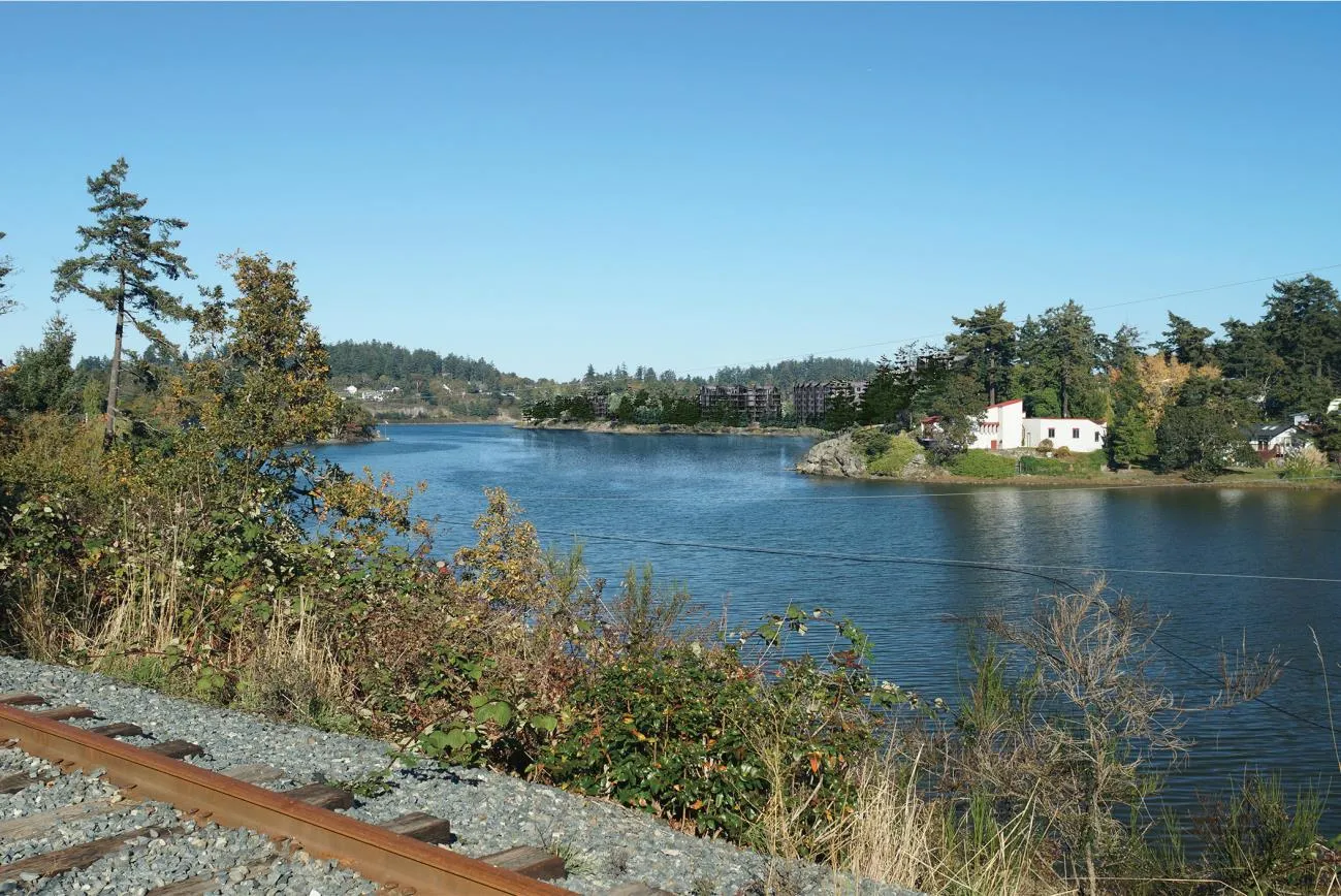
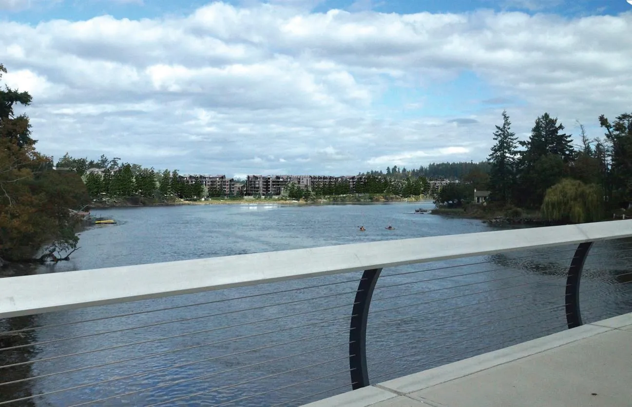
Visual impacts of the development could change in the future depending on several factors which can be determined at the Development Permit stage, including height and architectural style of the building, and tree planting or removal.
Existing and Proposed Site Coverage Comparison
| Existing | Area | Coverage |
|---|---|---|
| Surveyed Lot Area | 63,050m² | 100% |
| Paved Areas | 11,251m² | 17.8% |
| Building Footprints | 8,874m² | 14.2% |
| Landscaped Building Roof | 0m² | 0% |
| Natural and Landscaped Areas | 42,825m² | 68% |
| Proposed | Area | Coverage |
|---|---|---|
| Surveyed Lot Area | 63,050m² | 100% |
| Paved Areas | 7,507m² | 11.9% |
| Building Footprints | 17,234m² | 27.3% |
| Landscaped Building Roof | 3,735m² | 5.9% |
| Natural and Landscaped Areas (not including landscaped roofs) | 38,319m² | 60.8% |
| Natural and Landscaped Areas (including landscaped roofs) | 42,044m² | 66.7% |
Staff is proposing the following regulations to be included in the zone table:
Existing and Proposed Zoning
| Lot Size | RM-1 zone | Proposed CD zone |
|---|---|---|
| Lot size, minimum | 1,500m2 | 63,050m2 |
| Lot width, minimum | 18m | - |
| Lot Density | RM-1 zone | Proposed CD zone |
|---|---|---|
| Floor Space Ratio, Base Density | 0.6 | 1.15 |
| Floor Space Ratio with provision of 80% underground parking | Base +0.1 | - |
| Floor Space Ratio Bonus Density provision of 75% green roof | Base +0.1 | - |
| Lot Coverage, maximum | 40% | 30% |
| Impermeable Surface Coverage, maximum | 60% | 20% |
| Building Size | RM-1 zone | Proposed CD zone |
|---|---|---|
| Building Height, Maximum | 7.5m | 26m |
| Building Width, Minimum | 6m | 6m |
| Accessory Building Height, maximum | 4.5m | 4.5m |
| Siting of Principal Buildings and Other Structures | RM-1 zone | Proposed CD zone |
|---|---|---|
| Front Lot Line Setback, minimum (proposed will be width of property) | 7.5m | 15m |
| Rear Lot Line Setback, minimum | 6.0m | - |
| Side Lot Line Setback, minimum | 1.5m | - |
| Flanking Lot Line Setback, minimum | 4.5m | - |
| Siting of Accessory Buildings and Other Structures | RM-1 zone | Proposed CD zone |
|---|---|---|
| Siting of accessory buildings and structures | 1.2m | 15m |
| Minimum Flood Construction Level | RM-1 zone | Proposed CD zone |
|---|---|---|
| Minimum geodetic elevation of habitable areas | - | 3.5m |
| Minimum geodetic elevation of parkade entrances | - | 3.0m |
There is no front/side/flanking lot line setback as the lot lines adjacent to the natural boundary are covered by the special setback of 15m.
Parking Requirements
Off-street parking requirements are determined in the General Regulations of the Zoning Bylaw; this includes parking for vehicles and for bicycles. Parking space provision requirements cannot be amended by the rezoning process, but the provision of parking can impact the development potential on the property. It can have negative impacts on surrounding properties if insufficient parking is provided. The required provision of parking may be reduced with a variance.
Staff is not proposing site-specific parking requirements for the site.
The Zoning Bylaw requires the following parking space provisions:
| Unit Type | Off-street vehicle parking requirement per unit | Class 1 Bicycle Parking requirement | Class 2 Bicycle Parking Requirement (per bldg) |
|---|---|---|---|
| 0-1 bedroom unit | 1 | 1 | One 6-space rack |
| 2 bedroom unit | 1.5 | 1 | One 6-space rack |
| 3+ bedroom unit | 2 | 1 | One 6-space rack |
| Townhouse unit | 1.5 | 1 | One 6-space rack |
There are two types of bicycle parking spaces, defined within Section 5.11.2 of the Zoning Bylaw:
“Class 1” bicycle parking means a secure, weather-protected bicycle parking facility used to accommodate long-term parking, such as for residents or employees, usually within a building or covered, fenced area;
“Class 2” means a short-term visitor bicycle parking facility that may offer some security, and may be partially protected from the weather, for example a bike rack at a building’s entrance.
Vehicle Parking Requirements
There are two types of vehicle parking spaces described within the Zoning Bylaw:
- Standard parking space: 2.6m in width, 5.5m in length
- Small car parking space: 2.4m in width, 4.8m in length
Up to 30% of the required parking spaces can be supplied as small car spaces. Additionally, up to 15% of required vehicle parking spaces can be supplied as a $12,000 cash-in-lieu contribution to the provision of alternative transportation initiatives within the Town of View Royal. The 15% parking provision does not require Council or staff approval; it is an option available to an applicant as-of-right.
Proposed Vehicle Parking Provisions
The applicant is proposing 473 residential units, and has broken down the proposed vehicle parking in terms of visitor parking and assigned unit parking, where the visitor parking is at grade and the assigned parking is concealed. There is no distinction made between visitor parking and assigned parking within the Zoning Bylaw.
The total provision of parking is currently proposed at 594, with:
- 460 concealed assigned parking spaces
- 62 at-grade assigned parking spaces
- 72 visitor parking spaces
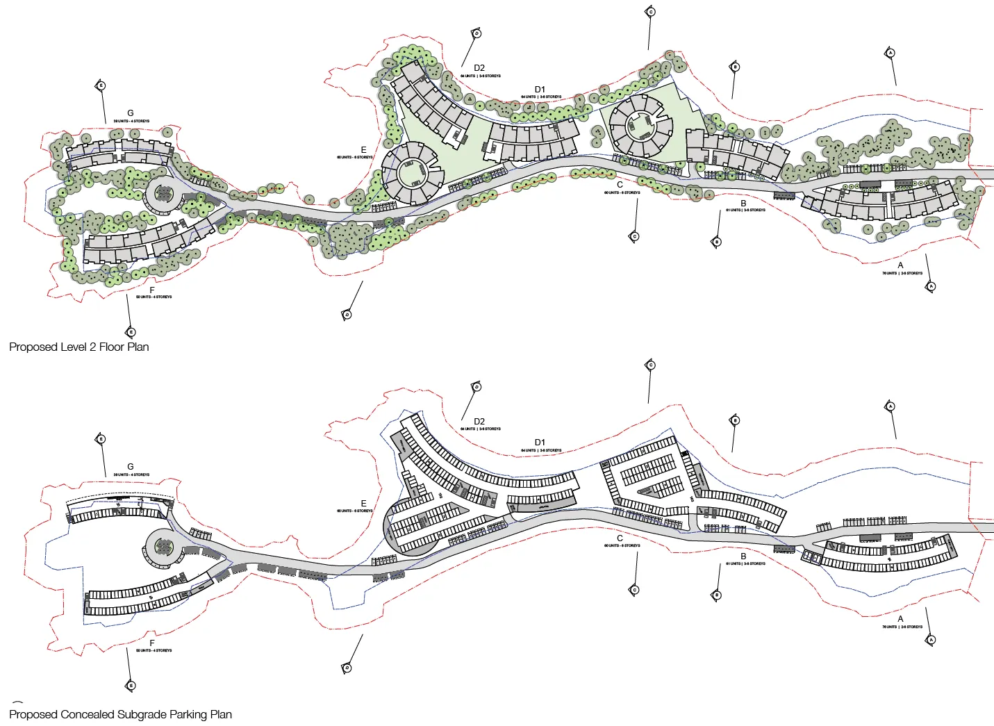
The final parking ratio proposed is currently proposed at 1.25 spaces per unit. If 15% of the proposed spaces (89 spaces) were provided with the cash-in-lieu scheme, the ratio would increase to a potentially more realistic 1.44 spaces per unit. The cash-in-lieu scheme in this scenario would generate $1,068,000.00 (at $12,000.00 per space) in funds available for alternative transportation projects within the Town of View Royal. The alternative transportation projects are not required to address the needs of the proposed project. An illustration of the proposed vehicle parking spaces is provided below (a larger illustration is provided in the attachments):
The supplied Traffic Impact Assessment by Bunt Engineering contemplates parking demand on the site, and concludes that the provided parking should be sufficient for the development. The final breakdown of residential unit types (townhouse, 1-br, 2-br etc.) within the development has not yet been determined, however, and as such, the final parking requirements for vehicle parking cannot yet be calculated. Thus, another potential variance at the time of Development Permit is relating to vehicle parking provision and the requirements for vehicle parking will be refined at time of Development Permit.
Proposed Bicycle Parking Provision
Bicycle parking requirements on-site are currently more certain. One Class 1 space is required per unit; 473 are required and 520 are proposed. More Class 2 spaces are being provided than required, with two 6-space bike racks outside Building A and one 6-space rack provided for each of the other buildings.
Staff has requested information relating to the provision of oversized cargo/utility bike parking, which would be provided at the Form and Character Development Permit stage. It is proposed that a bicycle maintenance station be included on-site; staff suggests that one should be required per building.
Sea Level Rise and Geotechnical Analysis
The applicant has engaged Ryzuk Geotechnical Engineering and has established that all factors associated with sea level rise over the anticipated lifespan of the buildings at 75 years result in a minimum flood construction level (FCL) at a 3.5m geodetic elevation. All habitable floor areas must be above this level. Staff is recommending that this figure be included in the zone table in the proposed zone. Flood-protected parking construction is also proposed, with all entrances to parking areas above 3m elevation.
The Ryzuk Geotechnical report considers all geotechnical engineering issues on-site, and has made recommendations for site development. There are no significant geotechnical issues of concern relating to the feasibility of the rezoning of the property and the current proposal.
Natural Environment
The site is currently within two Environmental Development Permit (DP) Areas as described and regulated within the Town of View Royal Official Community Plan Bylaw No. 811, 2011.
- Sensitive Terrestrial Ecosystem (across the entire site)
- Natural Watercourse and Shoreline Areas (15m above and below the average high water mark or ‘natural boundary’)
The purpose of these DP Areas is environmental protection. Each DP Area has specific guidelines which must be addressed by the application, and the details pertaining to the management of the site will be determined at that time.
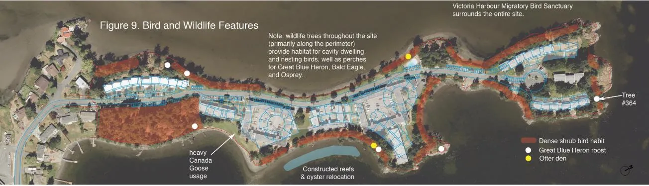
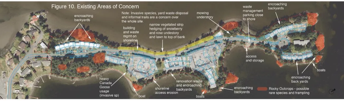
The applicant has submitted an environmental report from Swell Environmental. The report describes the overall site condition as such:
The overall site is a second growth Douglas-fir, arbutus and Garry oak forest with rocky outcrops that has been fragmented through historic development: primarily clearing and construction of infrastructure, buildings and landscaping. Informal paths were observed around the perimeter and crossing through the site, connecting with the road and buildings. Eroded areas where people regularly access the shoreline were also observed. Signs designating ‘Sensitive Environmental Areas’ were accompanied by pet-waste bag dispensers and trails, encouraging use of these areas for recreation.
The report maps the areas of existing ecological concern on the property, and outlines the ways in which the site’s ecological condition could be changed by the proposal. The report acknowledges that “the rezoning concept has been designed to minimize the ecological impacts of the increased density and building heights on the site”.
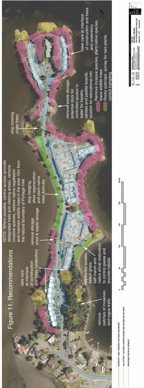
The report makes a series of recommendations, and at the Environmental DP stage staff will work closely with the applicant and their consultants to ensure that the recommendations are incorporated into the detailed site design and included as conditions of the permit.
The applicant proposes to implement a ‘Green Shores’ environmental program as “…a pilot project on Portage Inlet demonstrating best practices in coastal community development”. While such programs are undoubtedly beneficial, they cannot be expected to replace the Development Permit requirements. At the time of Development Permit, Staff will work with the applicant to determine how the Green Shores program can best be implemented on-site.
The environmental report summarizes:
Overall, the proposed rezoning conceptual design predominantly locates buildings and infrastructure within the footprint of existing buildings, infrastructure and landscaping, which is the primary approach to minimizing the ecological impacts of the proposed redevelopment. The project will also incorporate the structural, educational, and restoration recommendations above to protect and restore the areas of highest ecological value, and provide continued high value bird and wildlife habitat on the site, to assist in minimizing the effects of the increased density and larger buildings to attain a balance between development and environmental protection.
Staff will work with the applicant to refine the details within the report before the application comes forward to bylaw readings and Public Hearing.
Public Site Access and Open Spaces
Should the public be granted access over the property, staff is recommending that statutory rights-of-way be registered over portions of the property suitable for public access, and that these agreements contain requirements for owner maintenance and liability indemnification for the Town. Staff recommends that these areas be limited to trails and to areas of lower environmental concern. More detailed analysis and design recommendations will be made at the Development Permit stages.
Staff is recommending that the natural open spaces on the property be protected not by a parkland dedication to the Town, but rather by a covenant describing their location and maintenance requirements. Staff is currently exploring whether the Town is the appropriate covenantee, or whether another agency should be named.
Parkland dedication is not recommended by staff for the following reasons:
- Parkland dedication creates Town-owned parcels of land which reduces the area of the site and increases the density of the remaining developable portion of the property.
- Dedicated parkland must be maintained by the Town, which adds expense to the Town’s maintenance budget.
Federal Migratory Bird Sanctuary
The Victoria Harbour Migratory Bird Sanctuary covers a contiguous portion of waters below the natural boundary from Ten Mile Point in Saanich to Macaulay Point in Esquimalt.
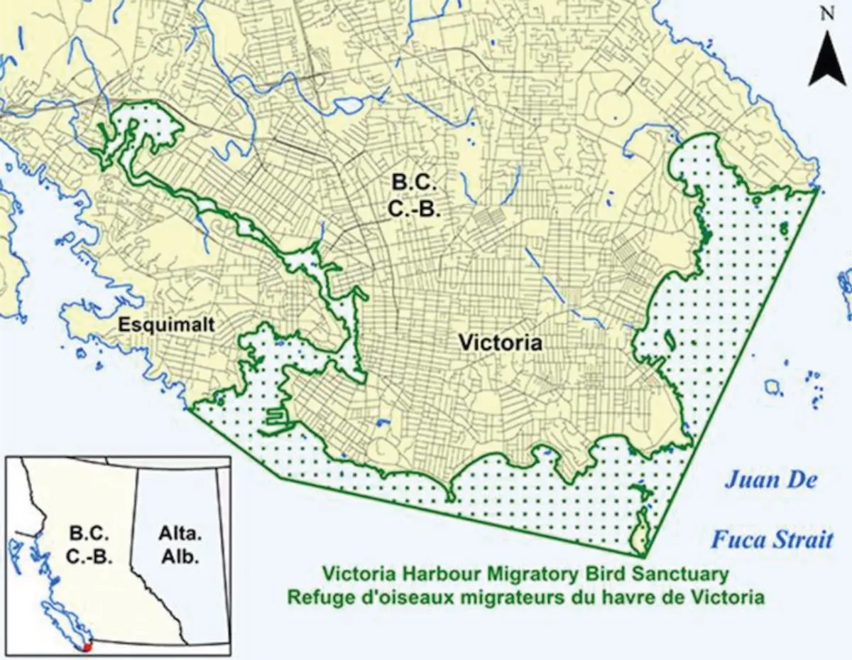
The Town has recently engaged the Canadian Wildlife Service regarding the purpose and management of Migratory Bird Sanctuaries. Several points were conveyed to the town:
- The Migratory Bird Sanctuary only applies below the natural boundary.
- The primary purpose of Migratory Bird Sanctuaries is the protection of migratory birds from killing, harm and harassment during a critical part of their life cycle, such as breeding, nesting, moulting, or staging and stopover during their migration.
- They were implemented to protect birds, eggs and nests from hunting-related activities and from harm by domestic cats and dogs.
- Most Migratory Bird Sanctuaries in BC are associated with stewardship-oriented groups and activities.
- Migratory Bird Sanctuaries work in conjunction with other federal, provincial and local regulations with respect to habitat protection.
The Swell environmental report states that one of the most important characteristics of the Christie Point site is the “juxtaposition of the shoreline forest to the extensive mudflats of Portage Inlet”. While it states that the existing fragmented patches of shoreline Douglas Firs provide “highly significant roosting locations for Great Blue Herons, Bald Eagles, Purple Martins, Belted Kingfishers, and Double-crested Cormorants”, it also says that no nesting evidence was observed on the site for any of the above species.
During the Development Permit process staff will make recommendations with respect to the the environmental report including the adoption of bird-friendly building design initiatives and the promotion of a stewardship program on-site.
Arborists’ Report and Tree Retention
The applicant has submitted an arborists’ report by Talbot Mackenzie and Associates outlining tree conditions and retention potential. There is also a supplied landscape master plan produced by Talbot and Mackenzie, Swell Environmental and LADR Landscape Architects which illustrates, among other landscape details, the tree retention, tree removal and tree planting proposal for the site.
Document Images
(3)