TOWN OF VIEW ROYAL COUNCIL REPORT - DEVELOPMENT PERMIT 2021/10 – 298 Island Highway
Staff report recommending approval for a development permit to construct a six-storey mixed-use building at 298 Island Highway, including parking and loading variances.
TOWN OF VIEW ROYAL
COUNCIL REPORT
TO: Mayor and Council DATE: October 29, 2021 FROM: J. Chow, MCIP RPP, Senior Planner MEETING DATE: November 2, 2021 FILE NO.: 3060-20-2021/10
DEVELOPMENT PERMIT 2021/10 – 298 Island Highway
RECOMMENDATION
THAT Development Permit 2021/10 be approved as per the October 29, 2021 report from the Senior Planner titled “Development Permit 2021/10 – 298 Island Highway” subject to Environmental Management Act requirements for approval;
AND THAT Development Permit 2021/10 include variances to provisions of Zoning Bylaw No. 900, 2014 for the following:
- Variance to the percentage of total parking spaces to be small car spaces in Section 5.5.3 from 30% to 60%
- Variance to the number of commercial loading spaces in Section 5.10, Table 3 from two to one
AND FURTHER THAT Development Permit 2021/10 include the following conditions:
- A covenant is to be registered prior to building permit issuance to secure the following: a. Commercial parking spaces to be available for shared use by visitors during nonbusiness hours b. Proposed communal rooftop deck not to be used between the hours of 10:00 pm and 7:00 am to avoid any excess noise
- Proposed encroachments are to be addressed prior to building permit issuance, at the applicant’s cost
- A 3 m x 3 m corner cut at the Island Highway / Helmcken Road intersection is to be dedicated as road prior to building permit issuance
- Exterior lighting is to be “dark skies friendly”
- A security deposit for onsite landscaping is to be provided prior to building permit issuance.
CHIEF ADMINISTRATIVE OFFICER’S COMMENTS
I concur with the recommendation.
DIRECTOR OF DEVELOPMENT SERVICES’ COMMENTS
I concur with the recommendation.
DIRECTOR OF ENGINEERING’S COMMENTS
I concur with the recommendation.
PURPOSE OF REPORT
To consider a development permit to construct a six-storey mixed use commercial and residential building. Variances are requested for the percentage of small car spaces and the number of commercial loading spaces.
BACKGROUND
The 1853 m² subject property is located at the east corner of the Island Highway / Helmcken Road intersection. In February 2021 the Official Community Plan was amended to change the property land use designation from Neighbourhood Mixed Use to the new Neighbourhood Centre land use designation to permit the same uses with more density. The property was subsequently rezoned from C-1 (Community Commercial) to the new CD-26: Island Highway / Helmcken Comprehensive Development zone in keeping with the new land use designation. The single storey restaurant building that has occupied the lot since the early 1980s was demolished in September.
This application was introduced at the July 13, 2021 Committee of the Whole meeting. Follow-up information to address development permit area guidelines, zoning and servicing requirements is summarized in the corresponding sections of this report.
PROJECT INFORMATION
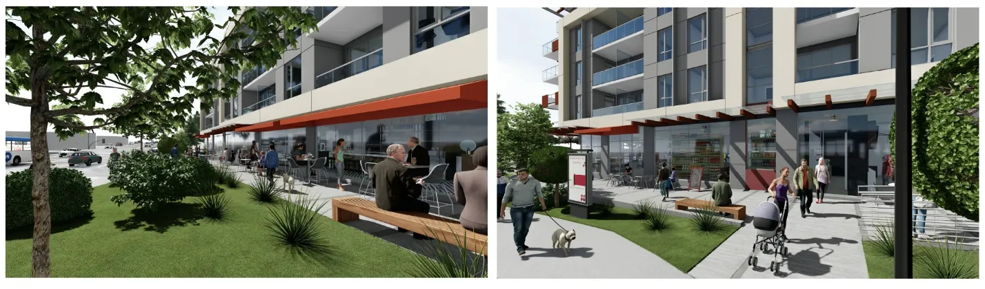
The proposal is to construct a six-storey building with a partially underbuilding parking lot accessed from Island Highway and two levels of underground parking accessed from Helmcken Road (Attachment 3). The upper two storeys would be set back to reduce massing at the street level as shown in Figures 1-3. There would be 560m² of commercial use on the ground floor with 55 condominium apartment units on the five upper floors in the following configuration:
- 19 one-bedroom units
- 35 two-bedroom units
- 1 three-bedroom unit
The adjacent Lions Cove Apartment is four storeys. The proposed building would be six storeys, but the ground floor would be sunk below the slope so the two buildings will have a relatively consistent roofline elevation as shown in Figure 2. Measures to enhance privacy include stepping the building from six storeys to three, two-metre-tall lattice screening of the communal rooftop deck, and proposed cedar hedge on the Lions Cove property to supplement the deciduous tree buffer (Figure 4).
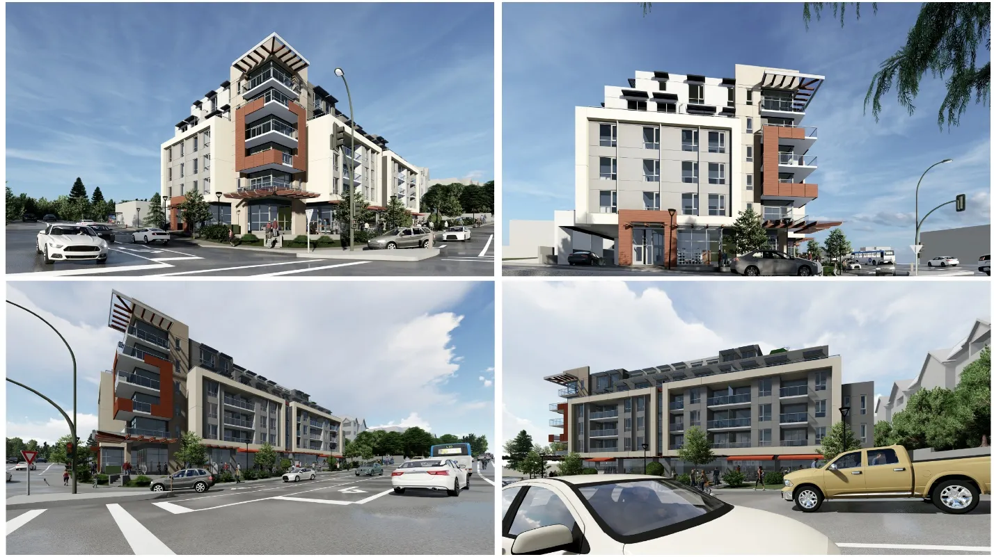
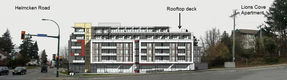
The abutting two storey houses on Eltham Road are designated Neighbourhood Mixed Use in the Official Community Plan and are zoned C-1: Community Commercial, so higher density uses can be anticipated in the future. Like the Island Highway frontage, the proposed building would be downslope with the upper two storeys stepped back.
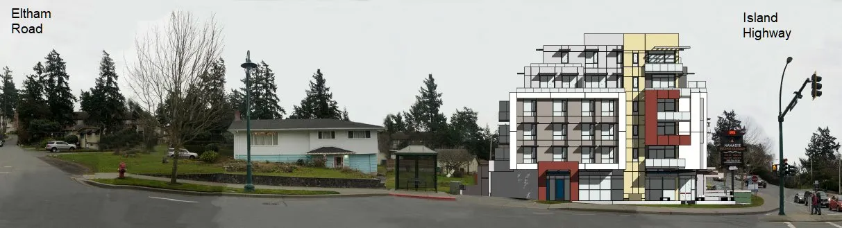
A pedestrian plaza on the Island Highway frontage would extend onto public land along as conceptually shown in Figures 4 and 5. This is possible because average depth of the boulevard along Island Highway is over 6m.
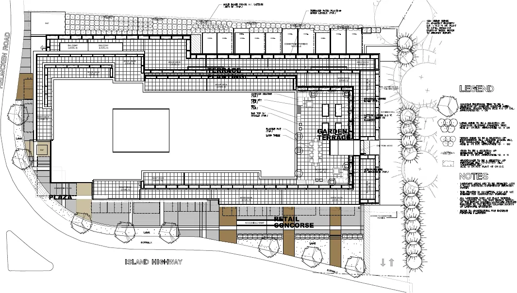
The following attachments to this report provide information relating to the proposal:
- Subject Property Map
- Subject Property Orthophoto
- Design Rationale - Ankenman Marchand Architects, (3 pages)
- Design Rationale - Ankenman Marchand Architects (3 pages)
- Architectural Drawings – Ankenman Marchand Architects, August 16, 2021 (38 pages)
- Landscape Plan - Lombard North Group, August 20, 2021
- Colour and Material Board - Ankenman Marchand Architects
- Exterior Furniture and Lighting - Ankenman Marchand Architects
- Preliminary Site Servicing Plan - JE Anderson, undated
- Stormwater Management calculations- JE Anderson, October 4, 2021
- Sustainability Checklist (8 pages)
- Development Permit Guidelines review (pages)
DISCUSSION
The issues for consideration include the following:
- Development Permit Area Guidelines
- Zoning and Variances
- Encroachments
- Site Servicing
- Environmental Management Act requirements
1. Development Permit Area Guidelines
The site is subject to the guidelines of the Neighbourhood Mixed Use development permit area. Initial review of the proposal indicates it is generally consistent with the guidelines (see Attachment 8), notably as follows:
- The building is located close to the street to engage with the pedestrian realm
- The top two floors of the six-storey building are set back to minimize the visual impact of the building height
- Extensive floor to ceiling glazing at the commercial ground floor contributes an inviting and high-quality streetscape
- There are no opportunities for large trees on the site, but the urban styled building provides a suitable backdrop for outdoor social gathering on the wide, pedestrian oriented boulevard
The following information has been provided to follow up the July 13, 2021 Committee of the Whole meeting: a. All roof top mechanical equipment and vents will be screened b. A colour and material sample board has been provided c. Fence details have been provided d. A master sign concept has been provided e. The communal deck perimeter facing abutting properties will have 2m lattice screening f. Concepts for street lighting standards and street furniture have been provided g. An arborist report has been prepared to mitigate construction impacts on trees located on adjacent properties h. The storm water management plan includes landscape design strategies i. Covenant to permit residential visitor use of commercial spaces during nonbusiness hours is recommended j. Exterior bike rack locations are shown on the plans k. ‘Dark skies friendly’ exterior lighting will be a development permit condition l. The location of outdoor electrical outlets to facilitate the installation of seasonal/decorative outdoor lighting will be addressed at the building permit stage m. A storm water detention tank will be located on Parking Level P1 n. Landscape plan notes all landscaping work and plant material shall conform to the most recent edition of the British Columbia Landscape Standard published by the British Columbia Society of Landscape Architects o. Opportunities for adaptable design features will explored at the building permit stage
To reduce the potential for excess noise, it is recommended that a covenant be registered prior to building permit issuance to require that the communal rooftop deck not be used between the hours of 10:00 pm and 7:00 am. The Town has had similar covenants registered for other buildings with communal decks.
2. Zoning and Variances
| CD-26: Island Highway / Helmcken Comprehensive Development Zone | Required | Proposed | Variance |
|---|---|---|---|
| Lot Size | |||
| Lot Size, minimum | 1500 m² | 1853 m² | |
| Lot Density | |||
| Floor Space Ratio | 3.0:1 | 3.0:1 | |
| Lot Coverage, maximum | 75% | 75% | |
| Impermeable Surface Coverage, maximum | 80% | 80% | |
| Size of Principal Buildings and Other Structures | |||
| Building Height, maximum | 21.0m six storeys | 20.23m six storeys | |
| Building Width, minimum | 6m | 11.0m | |
| Siting of Buildings and Other Structures (Principal and Accessory) | |||
| Front Lot Line Setback, min. 1st to 4th storeys | 0m | 0m | |
| Front Lot Line Setback, min. 5th to 6th storeys | 2.0m | 2.0m | |
| Rear Lot Line Setback, minimum | 3.0m | 3.1m | |
| Side Lot Line Setback | 3.0m | 3.1m | |
| Flanking Lot Line Setback, min. 1st to 4th storeys | 0m | 0m | |
| Flanking Lot Line Setback, min. 5th to 6th storeys | 2.0m | 2.0m |
Document Images
(2)