Shoreline Development Permit Guideline Analysis
A table evaluating the proposed development at 275 Kerwood Street against municipal shoreline development guidelines.
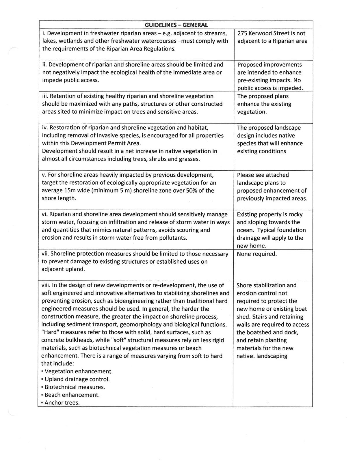
GUIDELINES – GENERAL
| GUIDELINES – GENERAL | |
|---|---|
| i. Development in freshwater riparian areas – e.g. adjacent to streams, lakes, wetlands and other freshwater watercourses –must comply with the requirements of the Riparian Area Regulations. | 275 Kerwood Street is not adjacent to a Riparian area |
| ii. Development of riparian and shoreline areas should be limited and not negatively impact the ecological health of the immediate area or impede public access. | Proposed improvements are intended to enhance pre-existing impacts. No public access is impeded. |
| iii. Retention of existing healthy riparian and shoreline vegetation should be maximized with any paths, structures or other constructed areas sited to minimize impact on trees and sensitive areas. | The proposed plans enhance the existing vegetation. |
| iv. Restoration of riparian and shoreline vegetation and habitat, including removal of invasive species, is encouraged for all properties within this Development Permit Area. Development should result in a net increase in native vegetation in almost all circumstances including trees, shrubs and grasses. | The proposed landscape design includes native species that will enhance existing conditions |
| v. For shoreline areas heavily impacted by previous development, target the restoration of ecologically appropriate vegetation for an average 15m wide (minimum 5 m) shoreline zone over 50% of the shore length. | Please see attached landscape plans to proposed enhancement of previously impacted areas. |
| vi. Riparian and shoreline area development should sensitively manage storm water, focusing on infiltration and release of storm water in ways and quantities that mimics natural patterns, avoids scouring and erosion and results in storm water free from pollutants. | Existing property is rocky and sloping towards the ocean. Typical foundation drainage will apply to the new home. |
| vii. Shoreline protection measures should be limited to those necessary to prevent damage to existing structures or established uses on adjacent upland. | None required. |
| viii. In the design of new developments or re-development, the use of soft engineered and innovative alternatives to stabilizing shorelines and preventing erosion, such as bioengineering rather than traditional hard engineered measures should be used. In general, the harder the construction measure, the greater the impact on shoreline process, including sediment transport, geomorphology and biological functions. “Hard” measures refer to those with solid, hard surfaces, such as concrete bulkheads, while “soft” structural measures rely on less rigid materials, such as biotechnical vegetation measures or beach enhancement. There is a range of measures varying from soft to hard that include: • Vegetation enhancement. • Upland drainage control. • Biotechnical measures. • Beach enhancement. • Anchor trees. |
Shore stabilization and erosion control not required to protect the new home or existing boat shed. Stairs and retaining walls are required to access the boatshed and dock, and retain planting materials for the new native. landscaping |
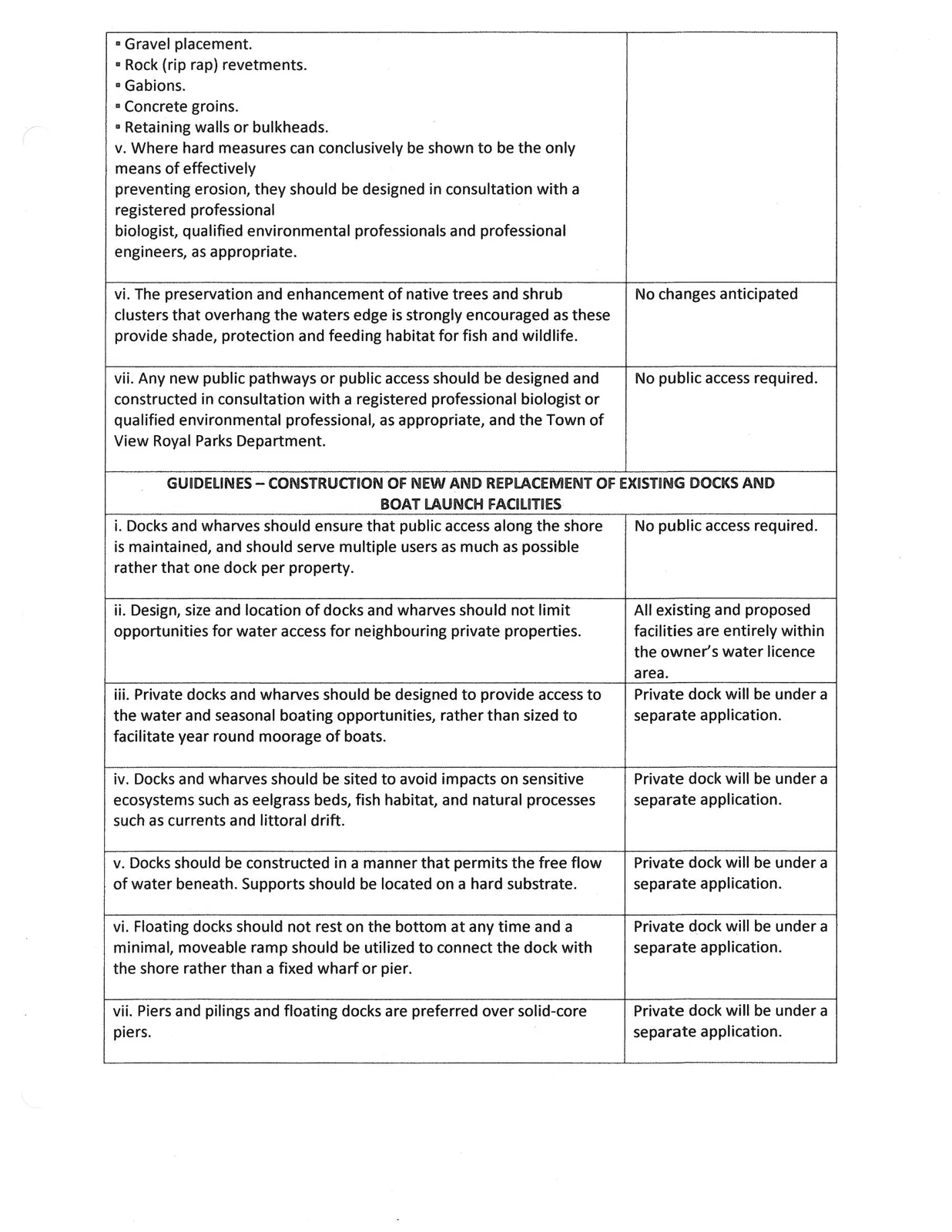
| • Gravel placement. • Rock (rip rap) revetments. • Gabions. • Concrete groins. • Retaining walls or bulkheads. v. Where hard measures can conclusively be shown to be the only means of effectively preventing erosion, they should be designed in consultation with a registered professional biologist, qualified environmental professionals and professional engineers, as appropriate. |
|
| vi. The preservation and enhancement of native trees and shrub clusters that overhang the waters edge is strongly encouraged as these provide shade, protection and feeding habitat for fish and wildlife. | No changes anticipated |
| vii. Any new public pathways or public access should be designed and constructed in consultation with a registered professional biologist or qualified environmental professional, as appropriate, and the Town of View Royal Parks Department. | No public access required. |
GUIDELINES – CONSTRUCTION OF NEW AND REPLACEMENT OF EXISTING DOCKS AND BOAT LAUNCH FACILITIES
| i. Docks and wharves should ensure that public access along the shore is maintained, and should serve multiple users as much as possible rather than that one dock per property. | No public access required. |
| ii. Design, size and location of docks and wharves should not limit opportunities for water access for neighbouring private properties. | All existing and proposed facilities are entirely within the owner's water licence area. |
| iii. Private docks and wharves should be designed to provide access to the water and seasonal boating opportunities, rather than sized to facilitate year round moorage of boats. | Private dock will be under a separate application. |
| iv. Docks and wharves should be sited to avoid impacts on sensitive ecosystems such as eelgrass beds, fish habitat, and natural processes such as currents and littoral drift. | Private dock will be under a separate application. |
| v. Docks should be constructed in a manner that permits the free flow of water beneath. Supports should be located on a hard substrate. | Private dock will be under a separate application. |
| vi. Floating docks should not rest on the bottom at any time and a minimal, moveable ramp should be utilized to connect the dock with the shore rather than a fixed wharf or pier. | Private dock will be under a separate application. |
| vii. Piers and pilings and floating docks are preferred over solid-core piers. | Private dock will be under a separate application. |
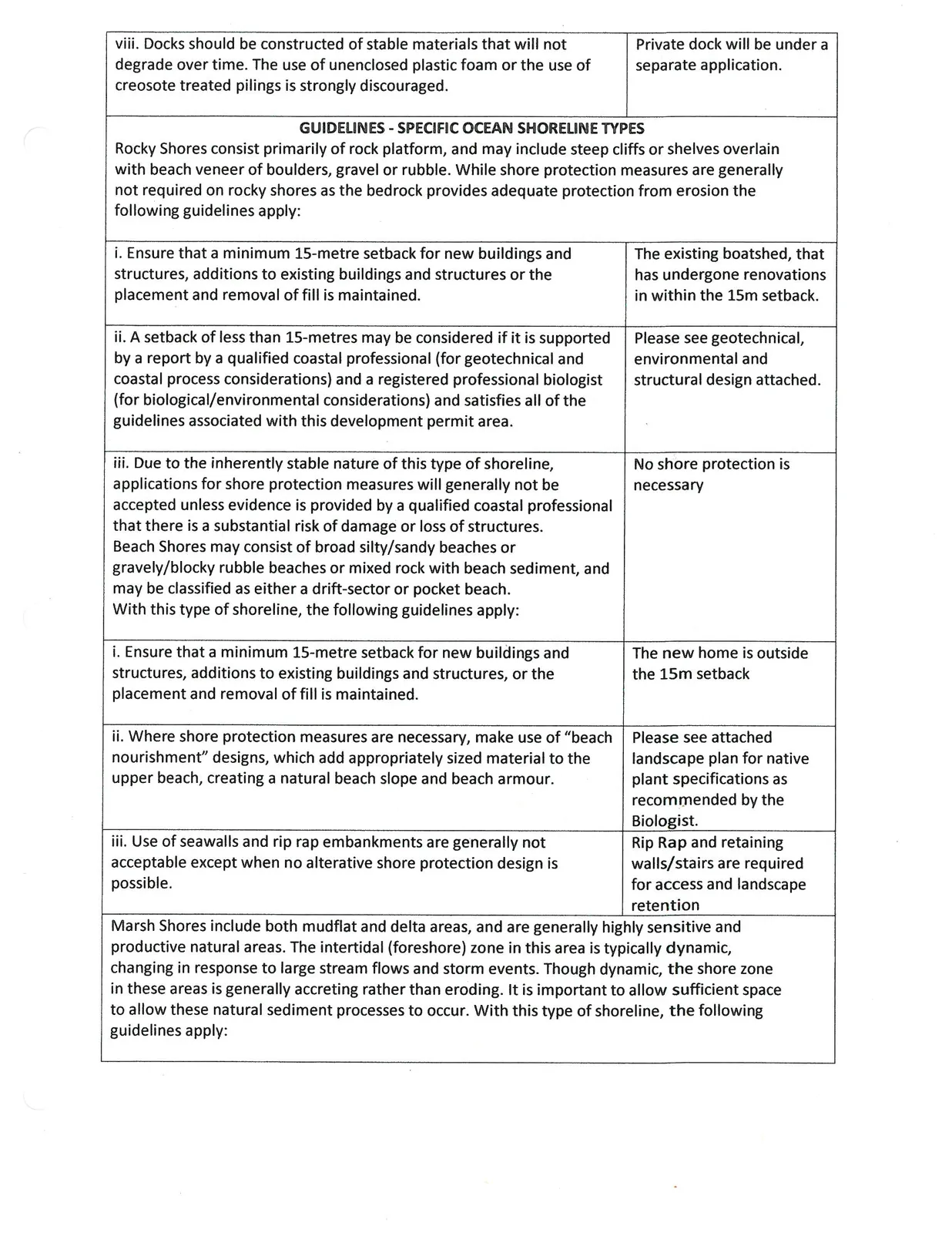
| viii. Docks should be constructed of stable materials that will not degrade over time. The use of unenclosed plastic foam or the use of creosote treated pilings is strongly discouraged. | Private dock will be under a separate application. |
GUIDELINES - SPECIFIC OCEAN SHORELINE TYPES
Rocky Shores
Rocky Shores consist primarily of rock platform, and may include steep cliffs or shelves overlain with beach veneer of boulders, gravel or rubble. While shore protection measures are generally not required on rocky shores as the bedrock provides adequate protection from erosion the following guidelines apply:
| i. Ensure that a minimum 15-metre setback for new buildings and structures, additions to existing buildings and structures or the placement and removal of fill is maintained. | The existing boatshed, that has undergone renovations in within the 15m setback. |
| ii. A setback of less than 15-metres may be considered if it is supported by a report by a qualified coastal professional (for geotechnical and coastal process considerations) and a registered professional biologist (for biological/environmental considerations) and satisfies all of the guidelines associated with this development permit area. | Please see geotechnical, environmental and structural design attached. |
| iii. Due to the inherently stable nature of this type of shoreline, applications for shore protection measures will generally not be accepted unless evidence is provided by a qualified coastal professional that there is a substantial risk of damage or loss of structures. | No shore protection is necessary |
Beach Shores
Beach Shores may consist of broad silty/sandy beaches or gravelly/blocky rubble beaches or mixed rock with beach sediment, and may be classified as either a drift-sector or pocket beach. With this type of shoreline, the following guidelines apply:
| i. Ensure that a minimum 15-metre setback for new buildings and structures, additions to existing buildings and structures, or the placement and removal of fill is maintained. | The new home is outside the 15m setback |
| ii. Where shore protection measures are necessary, make use of "beach nourishment" designs, which add appropriately sized material to the upper beach, creating a natural beach slope and beach armour. | Please see attached landscape plan for native plant specifications as recommended by the Biologist. |
| iii. Use of seawalls and rip rap embankments are generally not acceptable except when no alterative shore protection design is possible. | Rip Rap and retaining walls/stairs are required for access and landscape retention |
Marsh Shores
Marsh Shores include both mudflat and delta areas, and are generally highly sensitive and productive natural areas. The intertidal (foreshore) zone in this area is typically dynamic, changing in response to large stream flows and storm events. Though dynamic, the shore zone in these areas is generally accreting rather than eroding. It is important to allow sufficient space to allow these natural sediment processes to occur. With this type of shoreline, the following guidelines apply:
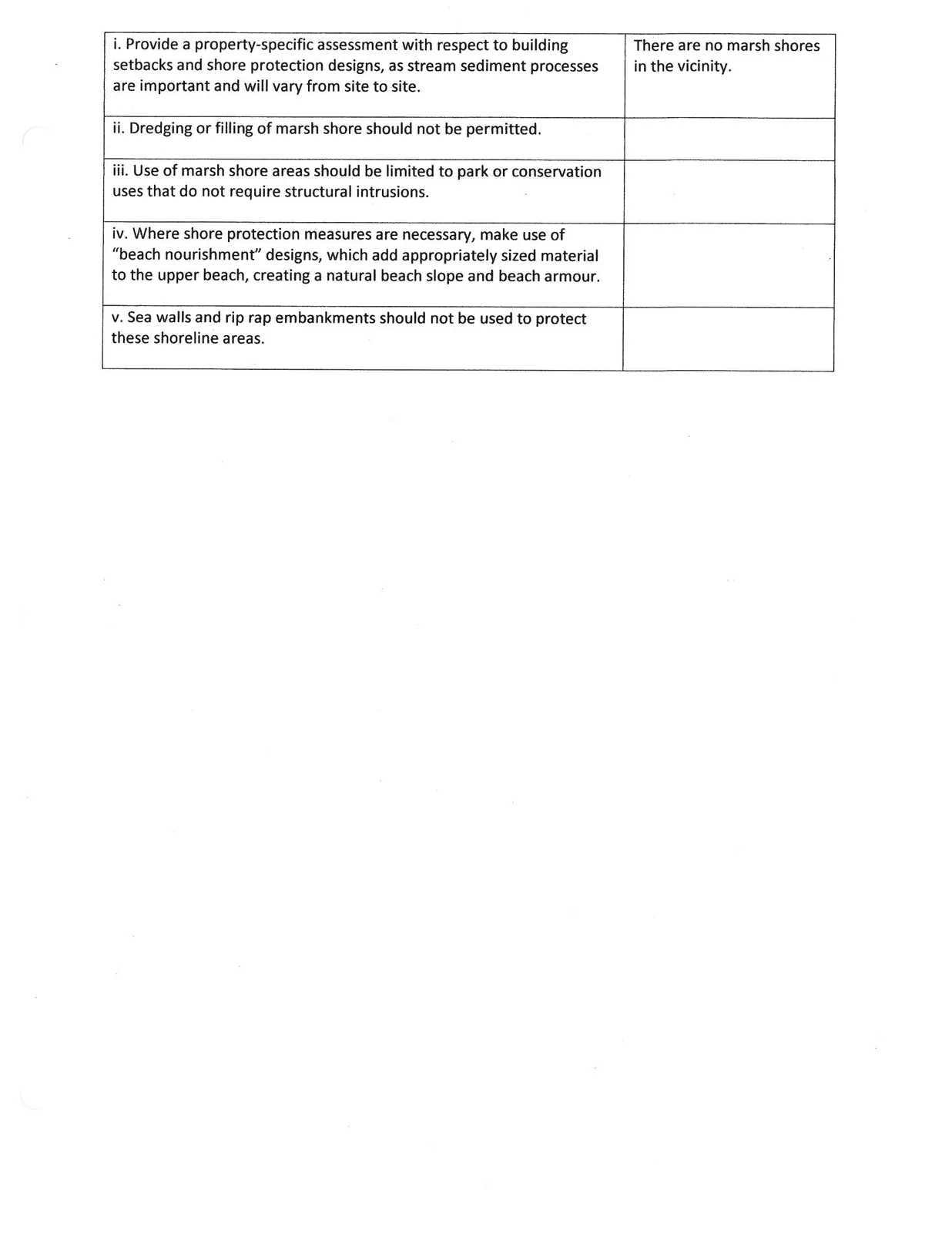
| i. Provide a property-specific assessment with respect to building setbacks and shore protection designs, as stream sediment processes are important and will vary from site to site. | There are no marsh shores in the vicinity. |
| ii. Dredging or filling of marsh shore should not be permitted. | |
| iii. Use of marsh shore areas should be limited to park or conservation uses that do not require structural intrusions. | |
| iv. Where shore protection measures are necessary, make use of "beach nourishment" designs, which add appropriately sized material to the upper beach, creating a natural beach slope and beach armour. | |
| v. Sea walls and rip rap embankments should not be used to protect these shoreline areas. |