TOWN OF VIEW ROYAL Council Report - DEVELOPMENT PERMIT 2020/03 – 280 Island Highway
Staff report recommending approval for amendments to a development permit regarding streetscape changes at 280 Island Highway.
TOWN OF VIEW ROYAL
Council Report
TO: Council FROM: J. Chow, Senior Planner DATE: April 6, 2020 MEETING DATE: April 14, 2020 FILE NO: 3060-20-2020/03
DEVELOPMENT PERMIT 2020/03 – 280 Island Highway
RECOMMENDATION:
THAT Development Permit No. 2020/03 be approved as per the April 6, 2020 report from the Senior Planner titled “Development Permit 2020/03 – 280 Island Highway”.
CHIEF ADMINISTRATIVE OFFICER’S COMMENTS:
I concur with the recommendation.
DIRECTOR OF DEVELOPMENT SERVICES’S COMMENTS:
I concur with the recommendation.
DIRECTOR OF ENGINEERING’S COMMENTS:
I concur with the recommendation.
PURPOSE OF REPORT:
To consider an amendment to Development Permit 2016/06 for streetscape changes at the Maija London condominium apartment site located at 280 Island Highway.
BACKGROUND
Development Permit 2016/06 was approved to permit the construction of the Maija London, a 37-unit four storey condominium apartment with underground parking. The building was completed in August 2019.
PROPOSAL:
The proposal is to amend the approved site and underground parking plan (Attachments 2-3) with new plans as shown in Attachments 4 and 5. This application has been submitted for Council’s consideration because:
- The number and extent of changes to the streetscape necessitate an amendment to the development permit.
- The changes were made after the building permit was issued and were realized by staff after occupancy had been granted.
The changes are shown in Figure 1 on the following page and are as follows:
- The side exit walkway and stairs to Island Highway were extended and relocated 18m away from the east side lot line (see Attachments 2 and 4)
- A landscape bed was converted to a raised planter
- A surface parking space was relocated into the underground parking area to accommodate a pad mounted transformer (see Attachments 3 and 5)
The changes were made for the following reasons:
- Side emergency exit stairs to the street were relocated from the west end of the property because of the topography and because they would conflict with underground parking below. The area between the underground parking and the front lot line was changed from a landscape area to an 18m walkway to provide an exit to the street. The plantings intended for that area were shifted closer to the building.
- The location of stormwater management infrastructure (Figure 3) meant the street level landscape bed had to be raised in a planter. The landscape architect has confirmed that the volume of soil in the planter is sufficient for the plants.
- One surface parking space at the driveway entrance was relocated into the underground parking area because a pad mounted transformer serving the building was required by BC Hydron in that location.
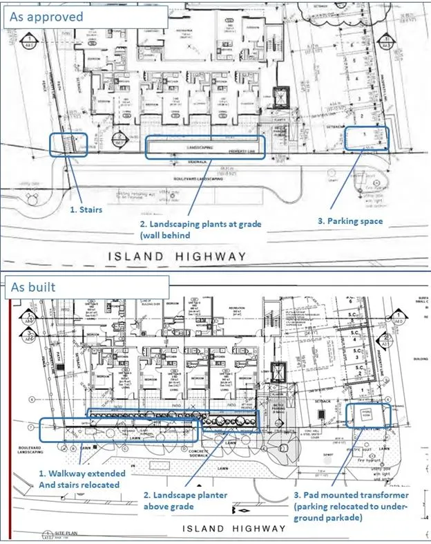
Figure 1. Site frontage as approved and as built
DISCUSSION:
The design in the approved development permit minimized the amount of retaining wall exposed at street level by carefully stepping part of it back and screening it with landscape planting as shown in Figure 2.
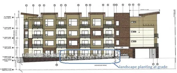
Figure 2. Streetscape as approved in Development Permit 2016/06
The length of the retaining wall results in more urban pedestrian streetscape, even though the stairs create a visual break.
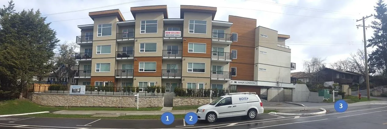
Figure 3. Streetscape as constructed
The landscape architect (Attachment 4) writes in support of the proposal, noting that:
- The overall required amount of onsite planting along the street frontage has been provided.
- Plants displaced by the walkway have been shifted away from the street but are still visible (i.e. the plants will grow to soften the façade at the street level and provide screening to ground floor units).
- The raised planter wall has an attractive stone finish continuing the line of the retaining wall.
However, the application can be supported as a compromise because:
- The changes were necessary to address three servicing issues that arose late in the development of the property.
- While the original design would have created a softer pedestrian streetscape, the changes are consistent with development permit guidelines as follows: a. There is still a combination of soft and hard landscape elements to create functional and visually appealing private and semi-private outdoor space b. The transition from public to private space is defined with hard and/or soft landscape elements through the use of transparent glass fencing with low hedging behind (see Figure 3). c. There are four boulevard trees in the boulevard in front of the retaining wall that will help break up the visual mass of the retaining wall once they mature.
- The amount of required planting on site has not been reduced. Plantings have been relocated elsewhere within the front yard and will continue to grow to soften the building façade, although not at the sidewalk level.
- The relocation of one surface parking space into the underground parking does not have a significant visual impact and does not affect the form and character of the development.
Council may decide on the application at the April 14, 2020 meeting because public notification is not required.
ALTERNATIVE RECOMMENDATION:
If Council considers that the proposal is not in keeping with the development permit guidelines, the application should be referred back to staff with direction to the applicant on what would make an acceptable application with regard to the guidelines.
RECOMMENDATION:
THAT Development Permit No. 2020/03 to amend Development Permit 2016/06 be approved as per the April 6, 2020 report from the Senior Planner titled “Development Permit 2020/03 – 280 Island Highway”.
SUBMITTED BY: Jeff Chow, MCIP, RPP – Senior Planner
REVIEWED BY: Lindsay Chase, Director of Development Services
Attachments:
- Property location plan
- Site Plan A1.0 (as approved) – Alan Lowe Architect Inc.
- Underground Parking Plan A2.0 (as approved) – Alan Lowe Architect Inc. October 25, 2019
- Site Plan A1.0 (as built) – Alan Lowe Architect Inc. October 25, 2019
- A2.0 Underground Parking Plan (as built) – Alan Lowe Architect Inc. October 25, 2019
- Letter from Landscape Architect - Lombard North Group, October 23, 2019
Document Images
(3)