Appendix: Photographic Documentation of 17 Eaton Avenue
A series of twelve photographs labeled #3 through #12 showing building envelope work, window installations, and structural framing at 17 Eaton Avenue.
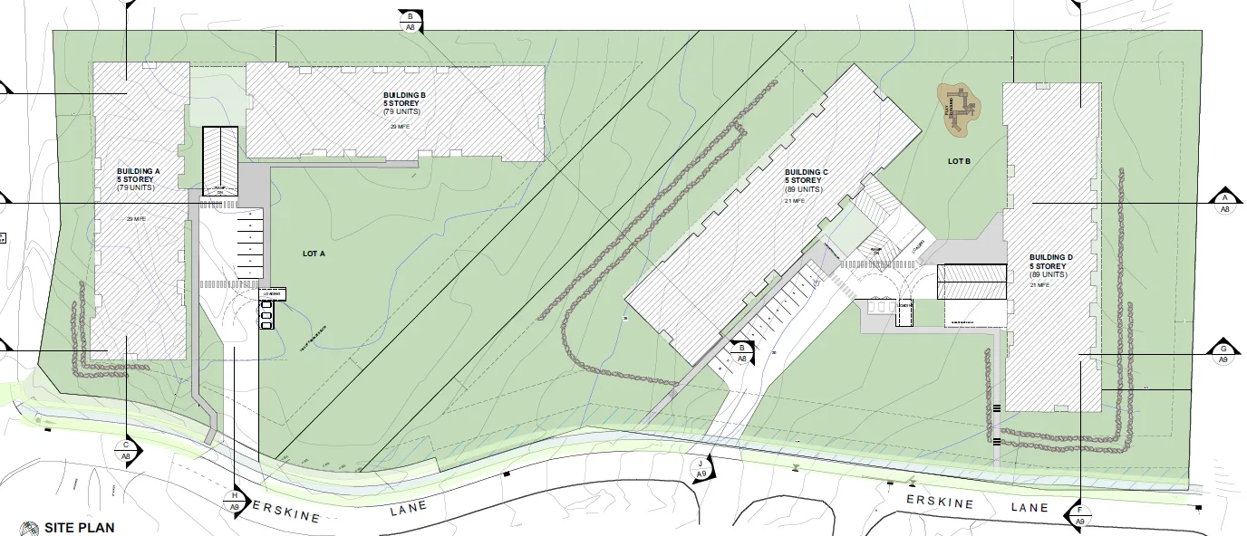
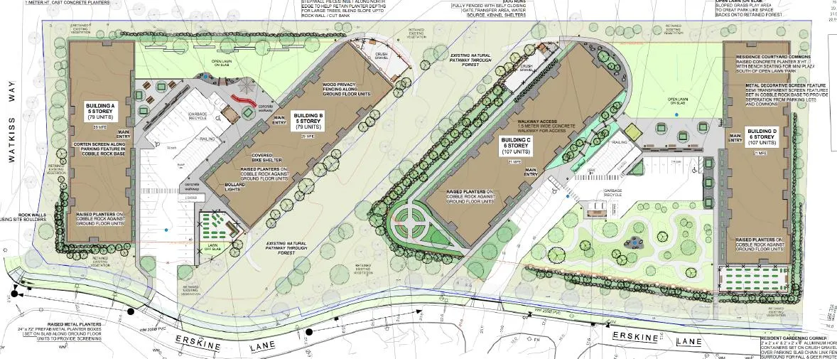
Future development permits will be required for this property to address the form and character of the development. The development permits may include a request to subdivide the split parcel into two lots. The CD Zone is drafted with the anticipation that the lot could be subdivided into two lots bisected by the CRD right-of-way. The development concept proposes 14.5m tall buildings.
The proposed zoning can be supported because it would comply with the policies encouraging the growth of the Hospital Neighbourhood Centre as a complete community as follows:
- Higher density at a neighbourhood center would be provided in a location that will promote walkability, cycling and transit use by locating more residences closer to services and employment.
- Higher density rental residential uses can increase workforce housing to support the Hospital and local businesses in the neighbourhood center.
- Increasing the supply of rental housing can assist with housing affordability in the region.
- Community amenity contributions are proposed that can be used to fund local improvements to enhance pedestrian safety and neighbourhood quality of life.
The development concept’s apartment unit mix is consistent with OCP objectives of socio-economic diversity (housing for young families and an aging population) and presents a high-quality design that would interface well with the surrounding neighbourhood. While the terrain does not support street-oriented buildings, the proposed setbacks would allow for a more natural, vegetated street edge. Other OCP policies to consider include accessible/adaptable units to support aging in place and those with physical constraints, energy efficiency and minimizing impact on urban forest cover.
While tree loss from development impact is not ideal with respect to OCP Policy NE1.7 to maintain healthy urban forest, this site is part of the Hospital Neighbourhood Centre, and is in a Change Area in the Official Community Plan where the Town has been working towards a higher density complete community where people can live close to where they work, play, and go to school, and where most of the necessities of everyday living are within walking distance. The development of this site was anticipated by its Mixed-Residential land use designation.
Design
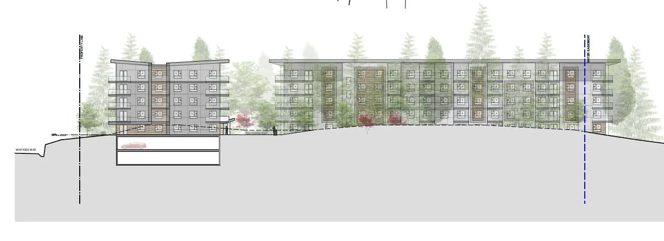
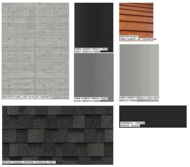
In consideration of the exclusively rental proposal, staff is aware of the necessity to balance design with cost effectiveness. The layout of the site has been changed, with a reconfiguration of the building locations. The four buildings are virtually identical in design and layout. The proposed materials are dark, natural tones of slate, cedar, concrete, grey and asphalt shingle roofing.
Detailed site design will be considered by Council at the time of Form and Character Development Permit.
The section indicated in red above is illustrated in elevation below:
Materials:
Transportation Impact
The Town commissioned a third part traffic engineering firm to review the traffic impact assessments. Revisions were made before the TIAs were accepted by the Town. The updated transportation impact assessment concludes that the development would not significantly impact the Watkiss Way/Erskine Lane intersection’s current Level of Service (A/B) and recommends that:
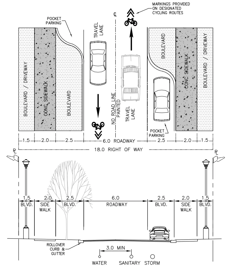
- The developer will provide a sidewalk along the Erskine Lane and Watkiss Way development frontages.
- The developer to implement TDM strategies (car share vehicles (2) and electric bicycle share (2)) to reduce vehicle traffic and encourage active modes.
- The developer to provide a roundabout at intersection of Watkiss Way and Erskine Lane.
- The developer to provide funds for upgrading the Hospital trail to at least a 3m gravel pathway.
Staff accepts the recommendations of the traffic impact assessment as requirements for the development, except for item 5 (which is not recommended as it is CRD-owned property as discussed later in the report). The applicant has offered to provide four carshare cars in this application. The provision of shared bikes and electric bicycles for onsite transportation demand management would be secured in a covenant.
Staff notes that while the assessment indicates the traffic generated by the development would not change the level of service at area intersections (particularly at the Watkiss/Helmcken intersection), it would still add to traffic volume and congestion in the study area. While the Transportation Impact Assessment does not indicate that a roundabout is warranted as a result of this development, the applicant recognizes that over the longer term, an intervention at this intersection will be necessary. As part of the application, they are offering to construct the roundabout in conjunction with the development.
Revision to Site Plan
The revision to the site plan and reduced number of units has had an impact on the traffic modelling. From the updated TIA:
In August 2020, a revision was made to the site plan which shows the reduced number of units for Lot B, effectively reducing two buildings by one floor (from six to five storeys). The development will now consist of 336 dwelling units in four mid-rise buildings (two of which remain six storeys and two of which are now reduced to five stories). Trip generation rates were re-estimated using the 10th Edition of the ITE Trip Generation Manual. Table 15 shows the updated estimated trips generated by the proposed development. They equate to 121 weekday AM peak hour trips and 148 weekday PM peak hour trips. Based on the revised site plan, the estimated site trips compared to Table 8 show 13 trips lower in the AM peak hour and 18 trips lower in the PM peak hour.
TABLE 15: PEAK HOUR DEVELOPMENT TRIPS
| Description | Units | Weekday AM In | Weekday AM Out | Weekday AM Total | Weekday PM In | Weekday PM Out | Weekday PM Total |
|---|---|---|---|---|---|---|---|
| Multi-Family Housing (Mid-Rise) | 336 | 32 | 89 | 121 | 90 | 58 | 148 |
Furthermore, it indicates that “the reduction in units (approximately 10%) will make a negligible difference as it pertains to traffic conditions previously analyzed”.
Parking
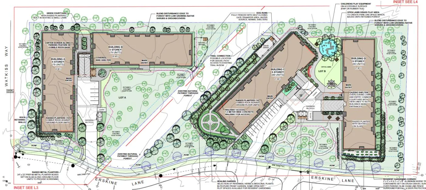
Two storeys of underground parking replace the prior proposal’s one storey, with a corresponding reduction in the provision of surface parking. This results in less disturbance and blasting on site and facilitate greater tree retention. Parking will be covered in greater detail at the development permit stage when the number of units is confirmed. In addition to a car and bike share to reduce automobile ownership and parking demand, the applicant proposes to provide a free transit for one year per unit to promote the use of transit by the initial occupants. This would be secured in a covenant.
Site Servicing
The requirements of Subdivision and Development Servicing Bylaw No. 985, 2017 include provision of sidewalks along the site frontages, no net increase in post-development site runoff, and that storm water entering the Town’s drainage system will meet the requirements of Storm Water Regulation Bylaw No. 902, 2015. The storm water management concept to be more detailed at the development permit stage is for vegetated swales outside of parkade slabs to collect storm water provide opportunities for treatment and infiltration prior to detention in underground storage tanks for controlled release into the municipal storm drain. The use of devices such as Stormceptors to treat storm water are common in this type of system.
The Engineering Department has confirmed that the additional sewer demand would be within the Town’s allocation for discharge to the regional sewer system.
Road dedication of approximately 3m will be required along the Erskine Lane frontage where the width of the road right-of-way is substandard. A covenant will be registered to secure provision of the road dedication prior to building permit issuance (unless a subdivision occurs first). The only section of Erskine Lane that would not meet current 20m road width standards would be at the CRD watermain intersection and 10 Erskine Lane, where road dedication would be a development requirement. As development occurs over time, the paved areas of Erksine Lane will widen to standard widths for two-way automobile travel shared with bicycles. Only on major roads are Bike lanes required on the road.
With the reduced density, Islander Engineering offers the following:
Because our captioned design brief was crafted for a higher density of the same usage, there are no concerns from an engineering site servicing or traffic perspective over and above what was identified in our Technical Design Brief dated October 9, 2019. In our professional opinion, there is no need to update our technical report during this land usage stage. Once the land is rezoned for the proposed use and a DP/BP is being considered, we would recommend that you revisit the densities so that Islander can revise conceptual designs.
Climate Change and the Environment
Since Council’s declaration of a Climate Emergency, it follows that applications to the Town should address this issue with a similar urgency. There are several OCP policies which speak directly to the OCP Objective NE4: Plan for climate change mitigation, adaption, and leadership.
The applicant has directly addressed these policies by proposing a compact purpose-built rental development with a diversity of housing formats, striving to retain trees on the site, promoting and supporting electric vehicle and bicycle use, car sharing, transit pass incentives and other transportation demand-side management initiatives. The site is close to services, employment centres, schools and the Galloping Goose regional pathway.
The site is not within a Sensitive Terrestrial Systems Development Permit Area; however, an environmental overview has been provided. The site contains a mature predominantly Douglas fir forest with some woodlands and Garry oak ecosystem on the north section. While these land types are commonly considered as sensitive ecosystems that may support ecological communities including red or blue listed species, this site is fragmented from other forest areas and contains invasive plant species at varying densities.
Tree Protection
Due to the reconfiguration of the parking, the applicant is proposing that 40% of the current tree coverage will be retained and is proposing to replant ‘over 250’ trees. Having tall narrow apartment buildings with minimal impervious lot coverage is the best building form for tree retention; lower buildings with the same density will necessarily remove more trees.
Additional consideration of tree protection and retention can be made by Council at time of Form and Character Development Permit.
Current proposal:
Previous proposal:
Should Council wish more detailed tree cover information staff can request that of the applicant and bring forward to Council at the time of first and second reading.
Bird Habitat
Active bird nests are protected between March and August under the Wildlife Act. No Bald Eagle or heron nest trees were encountered during the assessment. One nest was potentially a Cooper’s Hawk or Common Raven nest. The Province’s 2005 Best Management Practices for Raptor Conservation during Urban and Rural Land Development in British Columbia report notes the following about the Cooper’s Hawk:
- Among the species that are relatively compatible with human activity and are most likely to benefit from BMPs [best management practices] in urban and rural environments.
- Can nest near human developments.
- Prefers an area of interlocking tree canopy for rearing young.
- Greater Victoria contains one of the highest nesting densities of this species in North America.
Riparian Areas
A report from a registered professional biologist confirms that the ditch along the Watkiss Way frontage is not a watercourse and therefore not subject to the Riparian Areas Regulation.
Geotechnical
A geotechnical overview concludes there are no preliminary indications of geotechnical issues, although it notes that “careful consideration will be required if it is desired to build in vicinity of the 8.0 to 10m rock cut along the north east property line.” This includes areas where rock was quarried at 2 Hospital Way and along the Watkiss Way frontage.
Electric Vehicle Charging Stations
For this development concept, the Zoning Bylaw requires one electric vehicle charging station on the lot in a location which is accessible to visitors or residents. The development concept would provide pre-wiring for every vehicle spot.
Fire Protection
The Protective Services Department has no issues or concerns about providing fire service for the land uses in the proposed rezoning.
Public Engagement
In the previous application the applicant indicated that their public engagement initiatives included the following:
- January 2020 - door to door campaign in the Erskine Lane, Stoneridge and Eagle Creek Village areas
- January 27, 2020 - open house
- March 4, 2020 - open house
- July 2020 – Flyer distribution with link to the WestUrban website for information and opportunities for comment.
- October 5-6, 2020 – open house
With COVID opportunities for further public input in-person would likely have been limited. The current application here is a result of the engagement with the Town and the public, and the associated changes to the plan. The applicant has indicated that additional engagement will occur in the coming weeks once initial impressions of the application are gathered from Committee.
Community Amenity Contribution
In accordance with the Community Amenity Contributions Policy, the policy rate is $3,500 per attached residential unit. For this proposal, the amount would be 336 x $3,500 = $1,176,000. Note that required frontage improvements are not an amenity. It is recommended that the community amenity contribution rate and provision of the amenity be secured in a covenant as a condition of the rezoning. Contributions are received at the building permit stage and typically Council would then consider how the contributions can be spent or allocated. Several potential neighbourhood improvements have been identified so far:
Erskine Lane/Watkiss Way intersection
Area residents have expressed a strong desire for upgrades to enhance pedestrian safety and vehicle access, especially at the Erskine Lane/Watkiss Way intersection as traffic along Watkiss continues to increase. While the traffic impact assessment concludes that post-development volumes are within acceptable levels of service and intersection upgrades are not technically required at this time, the community amenity contributions from this proposal and from 7 Erskine Lane could be used towards improvements to provide better pedestrian and cyclist infrastructure in the areas of the Erskine/Watkiss intersection. Use of community amenity funds is at the discretion of Council. Section 4.7 of the transportation impact assessment explores several options and states:
“The roundabout has the least impact to traffic on Watkiss [Way] and provides the same or slightly better operations than a signal. Both the signal and the roundabout have the opportunity to provide crosswalks on all four legs. While a signal will provide for controlled crosswalks (with pedestrian signals), pedestrians at roundabout crosswalks only have to deal with one direction of traffic at a time and have a refuge area to wait in the middle of the roadway.”
The applicant is also prepared to upgrade the intersection of Watkiss Way and Erskine Lane to provide a roundabout. This would be formalized in a servicing agreement prior building permit issuance (or subdivision of the two-part lot).
Except for bike lanes and concrete sidewalks on Watkiss Way, these potential improvements to the Erskine Lane/Watkiss Way intersection are not on the Development Cost Charge project list.
Erskine Lane Improvements
Improvements to Erskine Lane will follow the Local 18m ROW Urban Class A standard within the Subdivision and Development Servicing Bylaw. There will be approximately 2 extra metres available for the potential widening of the sidewalk. Any change to the Local 18m ROW standard will require a variance.
Informal path between Erskine Lane and Hospital Way
The applicant is willing to help upgrade the informal path between Erskine Lane and Hospital Way. The path is unauthorized and traverses over CRD property and private land at 2 Hospital Way. Typically risk management practices do not support works or improvements that encourage trespass, so the Town cannot require improvements to or encourage trespass over other people’s privately held land as a condition of any rezoning.
If Council wishes to explore this further, Council will need to direct staff to investigate. The CRD has indicated would need detailed plans from the Town for formal consideration and notes initial items to address include liability and consent from owner of the adjoining property at 2 Hospital Way. Safety and maintenance are also items to consider.
Park improvements
At the January 7, 2020 joint meeting of the Community Development Advisory Committee and the Parks Recreation and Environment Committee reviewing the rezoning proposal for 7 Erskine Lane, there was support for community amenity upgrades to Game Nature Park, which is 4,000m² of parkland that was transferred to the Town in 2001 and is currently unimproved. A review of property records and a title search has not revealed any restrictions on the use of the land and as a small park, there is no master plan. Potential park improvements such as ecological restoration or enhancements to enable community use could be a consideration when the community amenity contributions are received for this application.
Regarding the position of a playground on-site, the proposal is for the structure to be positioned above the underground parking structure. This location is ideal in that it is not possible to place trees on that portion of the property.
Regional Housing Trust Fund
OCP Policy HS1.4 “Housing Amenity Contributions” also supports a “housing amenity” contribution to the Town, which could be directed to the Regional Housing Trust Fund. A portion of the cash community amenity contributions could be used for this purpose at Council’s discretion.
ANALYSIS AND DISCUSSION
The applicant has responded to Council input from the last application by providing a proposal with less units, lower density, lower height, more underground parking, a revised site layout, and other small refinements.
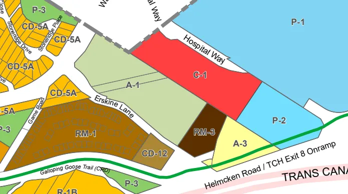
In comparison to the other recent rezoning immediately adjacent, 7 Erskine Lane is zoned RM-3 and proposed a higher maximum density (1.6 FSR) and similar building height (13.5m) than the proposed for 9 Erskine Lane.
Through the rezoning process, the applicant has offered to provide community amenity contributions in line with the Community Amenity Contributions Policy that would be sufficient to fund amenities desired by the neighbourhood, including improved/safer pedestrian and cyclist infrastructure. The development concept has continued to progress from an initial concept with extensive surface parking to one with underground parking and comprehensive onsite amenities for residents. The applicant has also agreed to several other commitments to support affordable housing and reduce automobile demand.
This site is part of the Hospital Neighbourhood Centre where all other properties on Erskine Lane are designated either Mixed Residential or Intensive Mixed Use in anticipation of higher density housing and other uses. The OCP policies consciously direct new growth into higher density mixed-use centers because auto-dependent suburban growth patterns and outward expansion are not supported to preserve green space and rural areas beyond the Urban Growth Boundary.
A sustainable community is where many people can live close to where they work, play, and go to school, and where most of the necessities of everyday living are located within walking distance. This is one of the few areas in Town that can be achieved, and it is reflected in the Official Community Plan land use designation. While development of this property would mean loss of mature second growth forest and woodland, the proposed land use and density proposed in this rezoning are in the right location to reduce the carbon footprint and per capital GHG emissions of the residents in accordance with the OCP’s sustainability objectives. The top generators of greenhouse gases in View Royal are from transportation and buildings.
This development application directly addresses the OCP policies related to compact, efficient, and diverse purpose-built rental housing forms within growth centres and sustainable development principles actively promoting low-emissions development. If the Town desires development which will respond to a climate emergency in form, location, housing typology and construction standard, this is the type of proposal which should be welcomed and encouraged.