Hospital Creek Estuary Restoration Project - Executive Summary
Project description and summary for the restoration of the Hospital Creek estuary to mitigate erosion and protect properties from sea-level rise.
Hospital Creek Estuary Restoration Project – Revised – IB – Oct 30, 2020
Peninsula Streams Society
Project Objectives:
Nourish the beach adjacent to Hospital Creek to help restore the estuary, protect properties against sea-level rise, provide forage fish habitat and improve overall beach aesthetics and accessibility for residents.
Executive Summary:
The Hospital Creek watershed consists of 221.6 ha of land within the District of Saanich and Town of View Royal (Figure 1&2). Draining into the Portage Inlet, the mainstem of Hospital Creek runs for 2.0 km primarily through agricultural fields in Saanich and urbanized areas in View Royal. Currently, very little of the natural Hospital Creek estuary remains intact and the remainder continues to erode away (Figure 4). Due to cumulative impacts from urban and residential development, and shoreline modification, many vulnerable habitats are under decline in the Portage Inlet. Habitats that depend on healthy estuaries, most notably mud flats and eelgrass meadows, are disappearing from Portage Inlet. Estuaries support diverse populations of birds, and provide critical nursery habitat for young salmonids and spawning habitat for forage fish. One of the most important ecosystem services provided by estuaries is their key role in protecting the coastline against erosion and sea-level rise. However, owing to the degradation of the Hospital Creek estuary, properties adjacent to the historical estuary are vulnerable to erosion, storm waves, and sea-level rise. There is an opportunity to restore and enhance the Hospital Creek estuary to benefit the ecosystem and residents of View Royal.
Beach nourishment refers to the strategic placement of material (e.g. sand and gravel) to eroding/eroded beaches. Added material is transported and reworked by nearshore processes to reach an equilibrium state. This method re-establishes the sediment budget to mitigate erosion, protect coastal infrastructure, and widen the usable zone for people and native flora and fauna. By restoring the Hospital Creek estuary, waterfront homes will be protected against seal-level rise and storm waves, as part of climate change adaptation for residents of View Royal. This project will improve access to Portage Inlet for a variety of recreational users, notably kayakers and paddle boarders. The added material will expand the usable zone for beach goers, with improved overall aesthetics. Ecological benefits will arise through the provision of spawning habitat for Forage Fish, a major food source for a variety of species in Portage Inlet, including salmon, birds, and marine mammals. Furthermore, this improved beach will significantly increase the available habitat for native species in the estuary. The zone adjacent to a freshwater source could serve as an ideal location for Deltoid Balsamroot (Balsamorhiza deltoides) habitat, which is extirpated in Portage Inlet, and is an endangered native plant species.
Project Description:
The Hospital Creek watershed consists of 221.6 ha of land within the District of Saanich and Town of View Royal (Figure 1&2). Draining into the Portage Inlet, the mainstem of Hospital Creek runs for 2.0 km primarily through agricultural fields in Saanich and urbanized areas in View Royal.
This project will be undertaken during the summer of 2021, coinciding with the summer window for projects near water to prevent any harm or impacts to fish and aquatic species. Prior to the restoration work, PSS will work with a team of experienced contractors to develop a strategic plan to efficiently complete the project activities while limiting disturbances to nearby residents and recreational users.
The beach will be nourished with a sand-gravel mix of rounded pebbles and sand, which will create a sandy foreshore and provide suitable spawning habitat for Forage Fish species that spawn on beaches including Pacific Sand Lance (Ammodytes hexapterus) and Surf Smelt (Hypomesus pretiosus). Larger rocks will be placed at the base of the beach and backfilled with sand. Wave-action will then move the coarser material, creating a tapered lens of sediment. The increased elevation of material will reduce incoming wave energy and armour the backshore. In front of the remnant estuary sediment, a layer of boulders and sand will protect the estuary and act as a reservoir to nourish the beach. These additions will prevent erosion, protect nearby residents from storm waves and sea-level rise associated with climate change, and provide critical habitat to native species in Portage Inlet.
A survey was undertaken on September 13th, 2019 to determine volumes of material needed to undertake the project (Figure 5). Seven polygons were laid out along the beach and measured using a reel. Elevations were determined using a laser level, providing information for trigonometric calculations used to determine areas and, subsequently, volumes. In total, the volume of all polygons amounts to 184.76 m³. However, only polygons 1-5 will be targeted for nourishment in 2021 with a total volume 156.81 m³.
PSS has received permission from the owners of 114 Chancellor Ave to access the beach through their property. Planks will be laid down to ensure the lawn is not disturbed while accessing the beach. As well, we have the support of the residents of Chancellor St and St. Giles Ave to undertake the project. In order to bring in machinery and material, beach access via Chancellor Ave will be improved. Post-nourishment, this entrance point will be improved considerably for kayakers and paddle boarders. Docks along the beach will either be raised and material tucked underneath, or temporarily moved until the work is completed.
The success of this project will be, in part, monitored by an graduate student at the University of Victoria, as part of Masters of Science program, supervised by Dr. Eva Kwoll, a geomorphologist specialized in coastal dynamics. The research project will model the longshore drift in this area of Hospital Creek, which will help predict the transport of sediment along the estuary and subsequent beach.
This project directly aligns with the objectives detailed in the View Royal 2018 Annual Report. The town of View Royal has a commitment to sustainability, and a mission to achieve resilient vibrant community that balances social, environmental, and well-being (View Royal, 2018). The View Royal community plan recognizes the impacts of climate change and aims to mitigate them through environmental protection. As well, the unique environments within View Royal, in particular, the Gorge Waterway and Portage Inlet, provide the community a variety of natural amenities for recreation (View Royal, 2016). Ultimately, the Hospital Creek estuary restoration project, will help View Royal reach their environmental and ecological objectives, enhance recreational opportunities, and provide adaptation from climate change impacts.
Organization Description:
Peninsula Streams Society helps coordinate stream and beach restoration and habitat conservation projects. We provide our associated groups with technical expertise and resources to help achieve their goals. Our goal is to achieve healthy aquatic habitat that supports self-sustaining populations of native species in both freshwater and marine environments. We accomplish this objective through research, restoration, innovative projects, public education, and private land stewardship.
Figures:
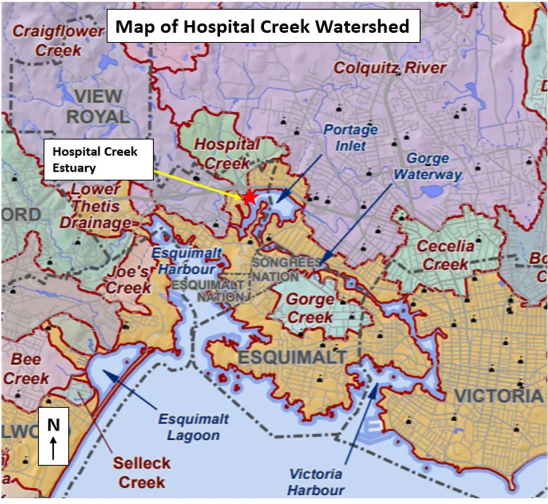
Figure 1. Map of Hospital Creek Watershed.
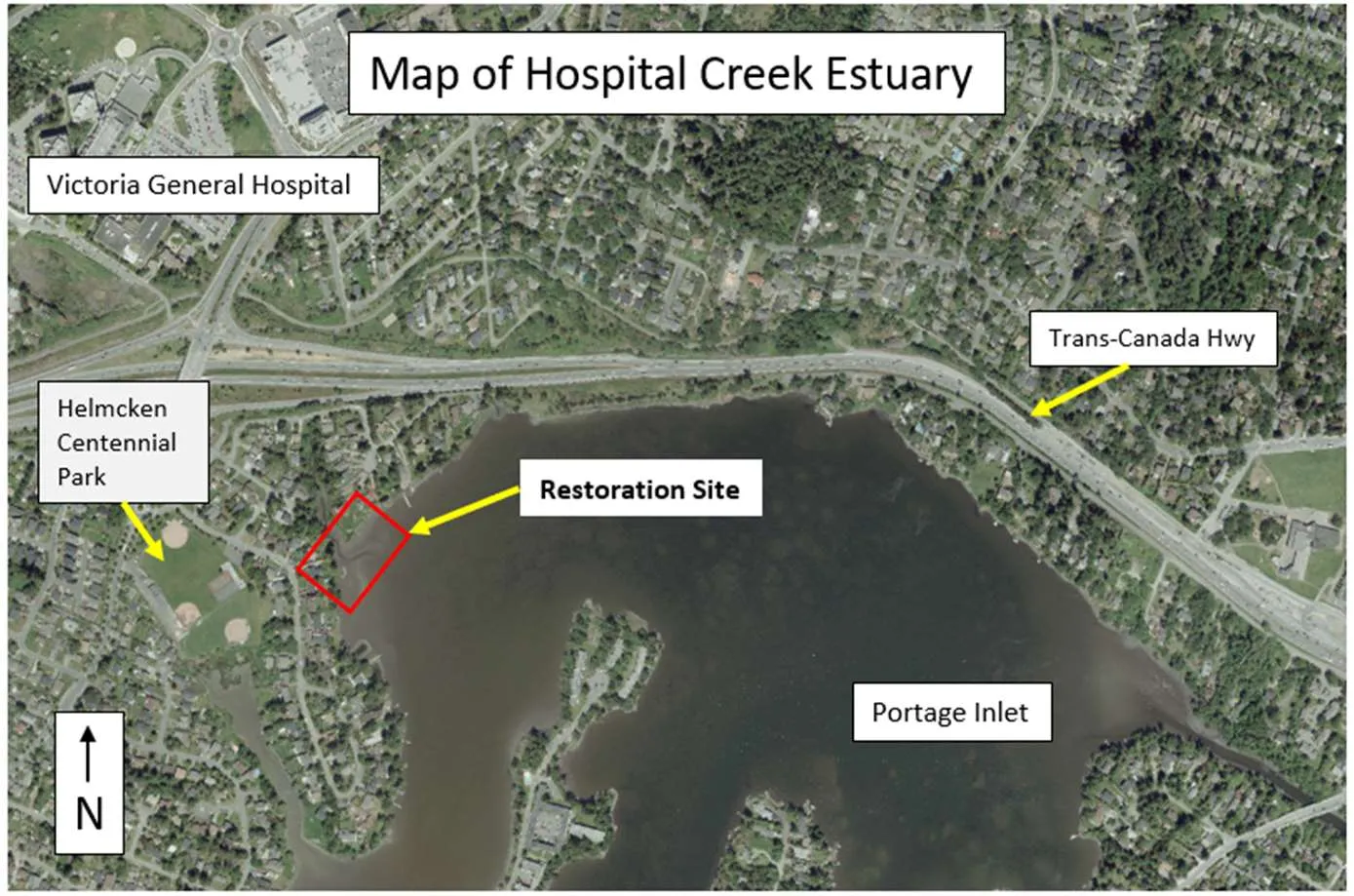
Figure 2. Map of Hospital Creek estuary, View Royal, B.C.
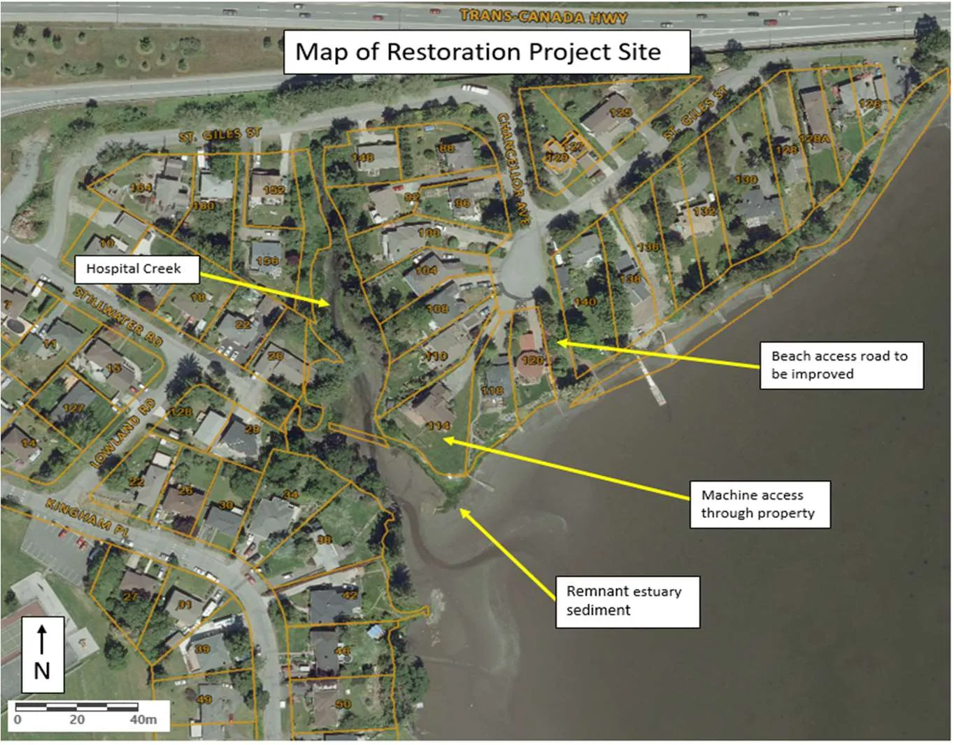
Figure 3. Map of Hospital Creek estuary restoration project site.
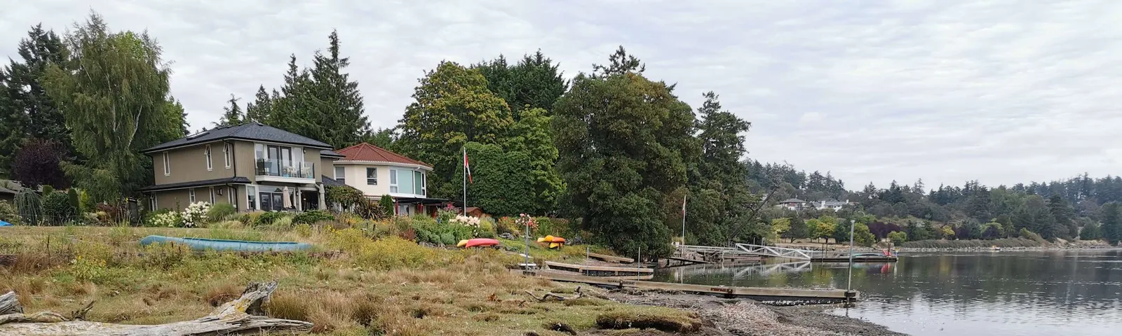
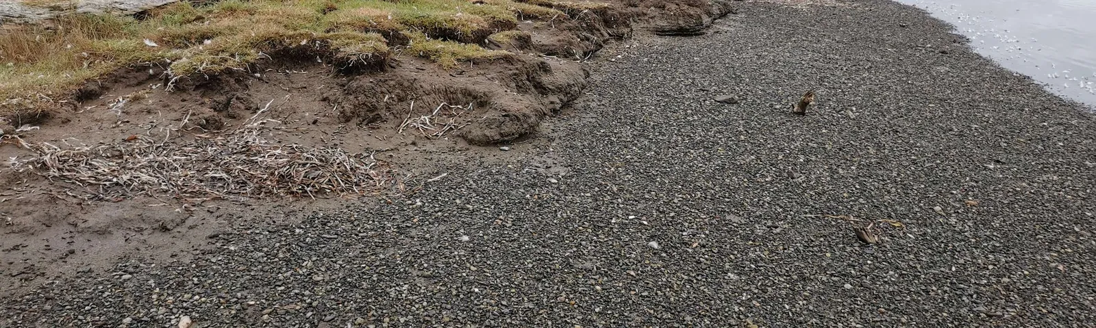
Figure 4. Erosion of Hospital Creek estuary sediment adjacent to waterfront homes of Chancellor Ave.
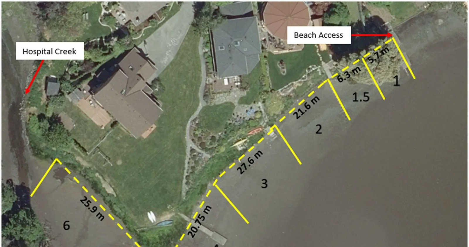
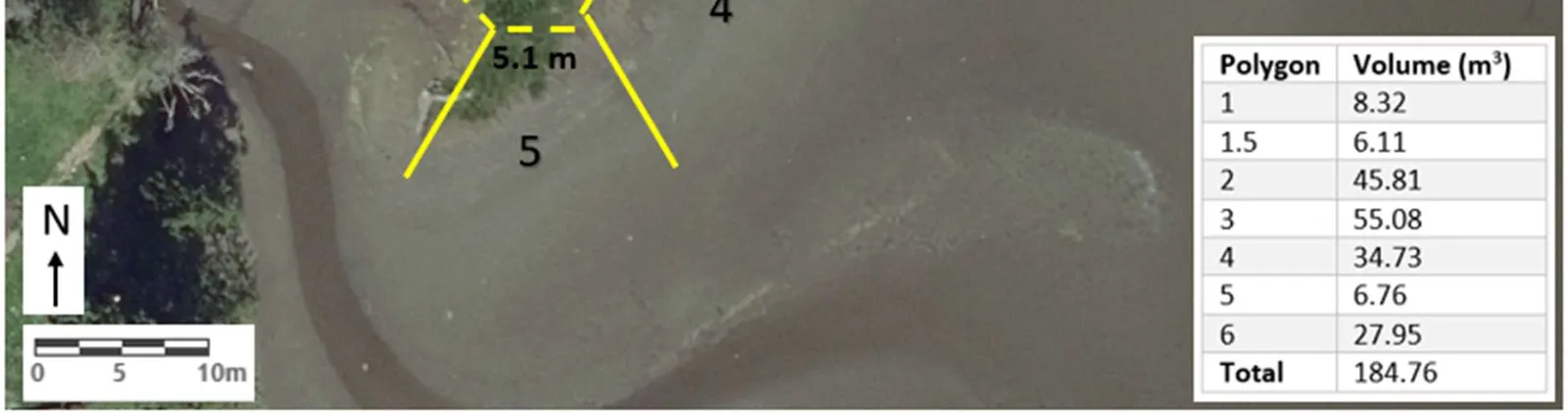
Figure 5. Areas to be restored along beach in Hospital Creek estuary. Table indicates approximate volumes (m³) of material that will be added to stabilize beach in each polygon. Areas 1-5 will be targeted for nourishment in 2019-20 with Area 6 being an area of interest for another year.
| Polygon | Volume (m³) |
|---|---|
| 1 | 8.32 |
| 1.5 | 6.11 |
| 2 | 45.81 |
| 3 | 55.08 |
| 4 | 34.73 |
| 5 | 6.76 |
| 6 | 27.95 |
| Total | 184.76 |
References:
Town of View Royal. (2011). Official Community Plan. View Royal, B.C., Canada. Town of View Royal View Royal. (2018). Annual Report. View Royal, B.C., Canada.
Document Images
(1)