TOWN OF VIEW ROYAL COUNCIL REPORT: REZONING APPLICATION 2020/02 – 9 ERSKINE LANE
A staff report from the Senior Planner regarding a rezoning application to change 9 Erskine Lane from Rural Residential (A-1) to Mixed Residential (RM-3) for a 372-unit multifamily development.
TOWN OF VIEW ROYAL COUNCIL REPORT
TO: Mayor & Council DATE: June 11, 2020 FROM: J. Chow, Senior Planner MEETING DATE: June 16, 2020
REZONING APPLICATION 2020/02 – 9 ERSKINE LANE
RECOMMENDATION:
THAT the June 11, 2020 report from the Senior Planner titled “Rezoning Application 2020/02 – 9 Erskine Lane” be received for information;
AND THAT, if first and second reading of Zoning Bylaw No. 900, 2014, Amendment Bylaw No. 1052, 2020 is passed at the June 16, 2020 Council meeting, Council set a Public Hearing date for Zoning Bylaw No. 900, 2014, Amendment Bylaw No. 1052, 2020 for July 7, 2020;
AND FURTHER THAT, coincident with final reading of Zoning Bylaw No. 900, 2014, Amendment Bylaw No. 1052, 2020, a covenant be registered on the lands at 9 Erskine Lane to secure the following prior to issuance of a building permit:
- a community amenity contribution of $3,500 per residential unit;
- road dedication along the Erskine Lane frontage;
- provision of a car share and bike share;
- a housing agreement to secure rental tenure for twenty years; and
- commitment to provide at least 44 three-bedroom units.
CHIEF ADMINISTRATIVE OFFICER’S COMMENTS: I concur with the recommendation.
DIRECTOR OF ENGINEERING’S COMMENTS: I concur with the recommendation.
DIRECTOR OF PROTECTIVE SERVICES’ COMMENTS: I concur with the recommendation.
PURPOSE:
- To continue review of a rezoning application to rezone the subject property from A-1: Rural Residential to RM-3 (Mixed Residential) for multifamily use. The development concept is for 372 rental units in four 5-6 storey apartment buildings
- To consider setting a Public Hearing date for Zoning Bylaw No. 900, 2014, Amendment Bylaw No. 1052, 2020 for July 7, 2020 if first and second reading of the bylaw is passed at the June 16, 2020 Council meeting.
SUMMARY OF NEW INFORMATION:
Additional information has been provided to address topics discussed at the March 10, 2020 Committee of the Whole meeting as follows:
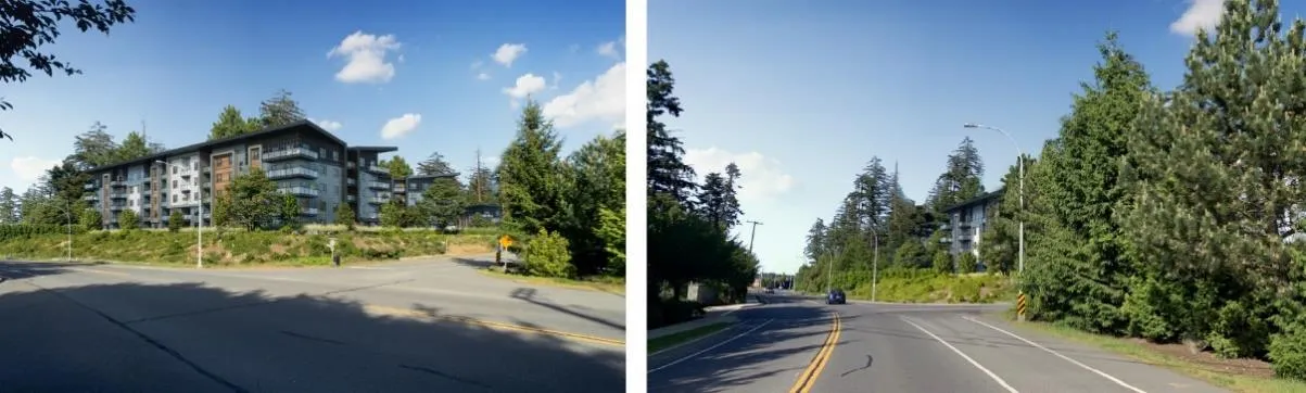
- A presentation (Attachment 3) explains the design concept to be formally considered at the development stage, including the following: a. Site design rationale for two five storey buildings at the high end of the site and two six storey buildings at the low end, with underground parking to be fully concealed. b. Tree management (Att 3. p22-24) i. Trees to be retained are within setback areas as buildings and underground parking occupy most of the permitted building envelope (Att 3. p23) ii. Approximately 30 trees would be retained along the Erskine Lane frontage. iii. Approximately six trees would be retained along the Watkiss Way frontage plus nine trees in the boulevard. iv. 129 trees on the perimeter (shown in red in Att 3. p2.3 and Att. 5 p2) would be removed due to proximity to foundations of buildings and underground parking, or are within locations in the areas to be dedicated for road and sidewalk on Erskine Lane v. 258 replacement trees would be provided. c. Onsite amenities (Attachment 5) to include raised planter boxes for resident container gardening, outdoor tables and seating, fenced dog runs with water and shelters, plaza and lawn passive open space, a herb/healing garden, and ‘discovery nature area’ with walking trails featuring native plant species salvaged from site clearing. d. New street view renderings can be found in Att.3 p28-30)
Updated Transportation Impact Assessment (Attachment 8) with information on how the Erskine/Watkiss intersection would operate best, post-development - including a review of the levels of service that alternative treatments such as signalization or the construction of a roundabout.
Agreement to register a covenant to secure the following: a. Community amenity contributions at a rate of $3,500 per residential unit. b. Road dedication along the Erskine Lane frontage to meet standard road right-of-way widths c. Two cars and electric bikes for residents to share d. A housing agreement to guarantee rental use only for twenty years. e. The provision of at least 44 three-bedroom units
Confirmation from a registered professional biologist that the ditch along the Watkiss Way frontage is not a watercourse subject to the Riparian Areas Regulation.
Sustainability checklist (Attachment 10).
BACKGROUND:
The 2.1ha subject property is bisected by a separately titled Capital Regional District (CRD) property that carries the regional water mains. A 1930s era house is located on the south portion the property. The remainder of the property is forested with some woodland and has uneven topography featuring shallow bedrock at the north end and clay deposits in the south. Surrounding land uses include:
- To the north across Watkiss Way: the Stoneridge subdivision and a large rural property at 1651 Burnside Road West in the District of Saanich that is within the Agricultural Land Reserve (ALR).
- To the east: a quarried vacant lot at 2 Hospital Way and a vacant, treed lot that is part of 1651 Burnside Road West in Saanich (also within the ALR).
- To the south: a proposed apartment building site at 7 Erskine Lane.
- To the west across the street: two detached residential properties, a 64-unit townhouse complex at 14 Erskine Lane, and a property with two houses at 10 Erskine Lane zoned for apartment use.
Some contamination from the adjacent property at 7 Erskine Lane has migrated onto the subject property. A site release was issued by the Provincial Contaminated Sites Branch that will permit independent remediation and allow this application to proceed through the rezoning process. A soil permit application is being prepared for submission to the Town in the near future to allow the removal of contaminated soil from 7 Erskine Lane and the subject property.
PROJECT INFORMATION:
The proposal is to rezone the subject property from R-1: Detached Residential (Large Lot) to RM-3 (Mixed Residential) in order to permit multifamily use. This rezoning application addresses zoning issues of land use, density, and standards for lot coverage, percentage of impervious surface, the height and siting of buildings in general.
The following attachments to this report provide information relating to the proposal (new/updated are items noted with *): 2. Letter from Applicant, January 22, 2020 (2 pages) 3. * Presentation for June 16, 2020 meeting (33 pages) 4. * Architectural Plans – Thuja Architecture Ltd., May 21, 2020 (13 pages) 5. * Landscape Plans – Lazzarin Svisdahl Landscape Architects, May 10, 2020 (4 pages) 6. Zoning Bylaw No. 900, 2014 excerpt: RM-3 Zone: Mixed Residential (2 pages) 7. Official Community Plan policies (9 pages) 8. * Transportation Impact Assessment – Watt Consulting Group, May 26, 2020 (35 pages) 9. Environmental Overview -, Environmental Dynamics Inc., November 18, 2019 (18 pages) 10. * Sustainability Checklist (10 pages)
While the subject property is adjacent to land in the Agricultural Land Reserve, that site at the corner of Hospital Way and Watkiss Way is a treed rocky bluff with limited potential for agricultural uses that would be affected by the proposed development.
Site Data Summary
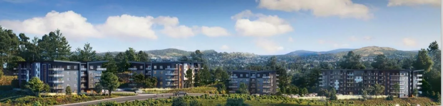
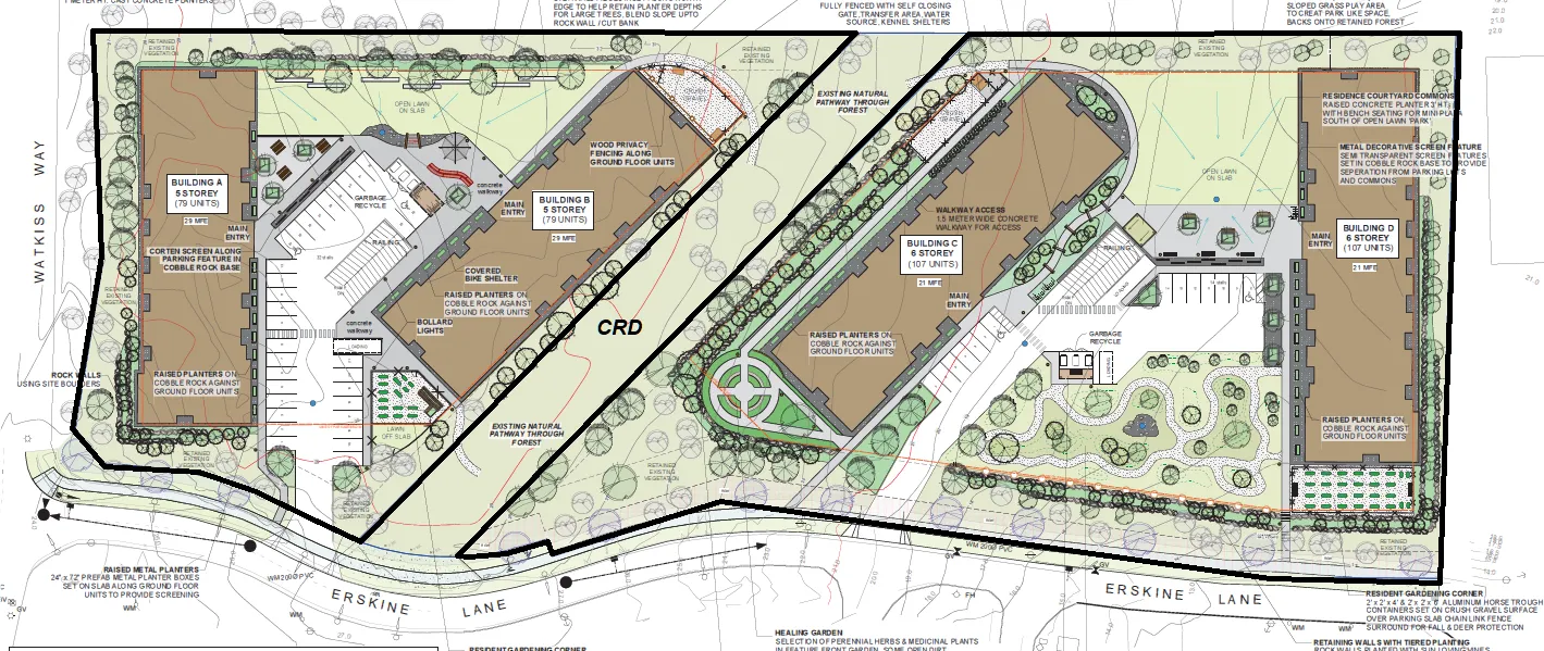
The applicant’s development concept is 372 rental units in four 5-6 storey apartment buildings as shown in Figures 1 and 2 and in Attachments 2-5. Most of the parking is proposed to be underground. If the rezoning is approved, a development permit application would be required to consider the form and character of the development and how it would address the zoning requirements, including building height, and parking. Unit and building configuration would also be finalized at that time.
Unit Mix
The proposal is currently for rental apartments in the following configuration:
| Lot A (north) | Lot B (south) | Total | |
|---|---|---|---|
| Buildings | 2 | 2 | 4 |
| Storeys | 5 | 6 | |
| Studio units | 8 | 10 | 18 |
| One-bedroom units | 70 | 108 | 178 |
| Two-bedroom units | 60 | 72 | 132 |
| Three-bedroom units | 20 | 24 | 44 |
| Total | 158 | 214 | 372 |
DISCUSSION:
Key issues include the following:
- Policy considerations
- Potential land use impacts
- Community amenity contribution
- Public consultation
- Potential budget implications
- Next steps for Council consideration of the proposal
1. Policy Considerations
The property’s Official Community Plan land use designation is “Mixed Residential”, which supports the following land uses and densities:
- Small lot detached houses
- Townhouses up to three storeys and a maximum 1.25:1 floor space ratio
- Four storeys for apartment dwellings and a maximum floor space ratio of 1.5:1
A member of Council previously inquired about the possibility of medical offices on this site. Commercial use of the site is not supported by the Official Community Plan as those types of medical/hospital related or supportive uses are envisioned to be located more to the east, along the Helmcken corridor.
The proposal to rezone to RM-3 Zone (Mixed Residential) (Attachment 6) can be supported because it would comply with OCP Policy LU1.5 “Mixed Residential” land use designation as follows:
| OCP Policy LU1.5 for Mixed Residential | Proposed RM-3 Zone | Development Concept |
|---|---|---|
| Max. Floor Space Ratio 1.5: 1 | 1.5: 1 | Lot A: 1.44:1 Lot B: 1.27 Total: 1.35 |
| Max. Storeys: 4 | (13.5m building height) | 5-6* (app. 15.5 -18.2m)* |
- Variance would be considered at the development permit stage.
Future development permits will be required for this property to address form and character issues. The development permits may include a request to subdivide the split parcel into two lots. The RM-3 zone would facilitate the development of the parcel as a whole, or as two parcels. The development concept proposes 15.5 -18.2m tall buildings, which would exceed the 13.5m height permitted in the RM-3 zone. These variances would be considered in a form and character development permit.
Official Community Plan policies relevant to the rezoning application are listed in Attachment 7. The proposed zoning can be supported because it would comply with the policies encouraging the growth of the Hospital Neighbourhood Centre as a complete community as follows:
- Higher density at a neighbourhood centre would be provided in a location that will promote walkability, cycling and transit use by bring people closer to transport, services and employment.
- Housing would increase workforce housing to support the Hospital and local businesses the neighbourhood centre is desirable
- Increasing the supply of rental housing will assist with housing affordability in the region
- Community amenities contributions are proposed that can help to improve local conditions and reduce the need for cars.
The development concept can also be supported as the apartment unit mix supports socio-economic diversity (young families and an aging population) and because the development concept at this initial stage presents a high-quality design that interfaces well with the surrounding neighbourhood. While the terrain does not support street-oriented buildings, the setbacks would allow for a more natural, vegetated street edge. Other OCP policies to consider include accessible/adaptable units to support aging in place and those with physical constraints; energy efficiency and minimizing impact on urban forest cover.
The proposal for 44 three-bedroom units would provide family oriented rental housing in an area close to an elementary school. The applicant has agreed to commit to that through a covenant.
2. Potential Land Use Impacts
a. Transportation and Parking The updated transportation impact assessment (Attachment 8) concludes that the development would not significantly impact the Watkiss Way/Erskine Lane intersection’s current Level of Service (A/B) and recommends that:
- “The developer will provide a sidewalk along the Erskine Lane and Watkiss Way development frontages.
- The developer to implement TDM strategies (car share vehicles (2) and electric bicycle share (2)) to reduce vehicle traffic and encourage active modes.
- The developer to provide a left turn lane on Watkiss Way at Erskine Lane.
- The developer to contribute towards the signalization of Erskine Lane / Watkiss Way.
- The developer to provide funds for upgrading the Hospital trail to at least a 3m gravel pathway.”
Staff accepts the recommendations of the traffic impact assessment as requirements for the development save for item 5 given that this informal trail is on the CRD’s fee simple land and leads to and over a privately held property. The Town cannot require improvements to or encourage trespass over other people’s privately held land as a condition of any rezoning. The provision of shared car and electric bicycles for onsite transportation demand management would be secured in a covenant. Staff notes that while the assessment indicates the traffic generated by the development would not change the level of service at area intersections (particularly at the Watkiss/Helmcken intersection), it would still add to traffic volume and congestion in the study area.
Parking will be covered in greater detail at the development permit stage when the number of units is confirmed, however the development concept proposes to meet zoning requirements by providing 485 parking spaces where 480 is required based on the proposed number and mix of units.
b. Servicing Impacts The requirements of Subdivision and Development Servicing Bylaw No. 985, 2017 include provision of sidewalks along the site frontages, no net increase in post-development site runoff, and that storm water entering the Town’s drainage system will meet the requirements of Storm Water Regulation Bylaw No. 902, 2015. The Engineering Department has confirmed that there is adequate sewer capacity with regard to the Town’s allocation for discharge to the regional sewer system.
Road dedication of approximately 3m will be required along the Erskine Lane frontage where the width of the road right-of-way is substandard. A covenant will be registered to secure provision of the road dedication at the subdivision or building permit stage.
c. Environmental Impacts The site is not within the Sensitive Terrestrial Systems Development Permit Area; however, this section summarizes the key findings of the environmental overview in Attachment 9. The site is a mature predominantly Douglas fir forest with some woodlands and Garry oak ecosystem on the north section. While the woodlands are classified as sensitive ecosystems that can support ecological communities including red or blue listed species, the site is fragmented from other forest areas and contains invasive plant species at varying densities.
Active bird nests are protected between March and August under the Wildlife Act. No Bald Eagle or heron nest trees were encountered during the assessment. One nest was potentially a Cooper’s Hawk or Common Raven nest. The Province’s 2005 Best Management Practices for Raptor Conservation during Urban and Rural Land Development in British Columbia report notes the following about the Cooper’s Hawk:
- Among the species that are relatively compatible with human activity and are most likely to benefit from BMPs [best management practices] in urban and rural environments.
- Can nest in close proximity to human developments
- prefers an area of interlocking tree canopy for rearing young
- Greater Victoria contains one of the highest nesting densities of this species in North America
A report from a registered professional biologist confirms that the ditch along the Watkiss Way frontage is not a watercourse and therefore not subject to the Riparian Areas Regulation.
A geotechnical overview concludes there are no preliminary indications of geotechnical issues, although it notes that “careful consideration will be required if it is desired to build in vicinity of the 8.0 to 10m rock cut along the north east property line.” This includes areas where rock was quarried at 2 Hospital Way and along the Watkiss Way frontage.
d. Fire Service The Protective Services Department has no issues or concerns about providing fire service for the land uses in the proposed rezoning.
3. Community Amenity Contributions
In accordance with the Community Amenity Contributions Policy, the applicant has agreed to offer the standard rate of $3,500 per multifamily residential unit. For this proposal, the amount would be 372 x $3,500 = $1,302,000. We note that the required frontage improvements are not included as an amenity. It is recommended that the agreed upon community amenity contribution rate and provision of the amenity be secured in a covenant as a condition of the rezoning. Once the contributions are received at the building permit stage Council can consider how the contributions can be spent or allocated.
Area residents have expressed a desire for upgrades to enhance pedestrian safety and vehicle access at the Erskine Lane/Watkiss Way intersection as traffic through the intersection continues to increase. While the traffic impact assessment concludes that post-development volumes are within acceptable levels of service, the community amenity contributions from this proposal and from 7 Erskine Lane could be used towards improvements at the Erskine/Watkiss intersection. Section 4.7 of the transportation impact assessment explores several options and states:
“The roundabout has the least impact to traffic on Watkiss [Way] and provides the same or slightly better operations than a signal. Both the signal and the roundabout have the opportunity to provide crosswalks on all four legs. While a signal will provide for controlled crosswalks (with pedestrian signals), pedestrians at roundabout crosswalks only have to deal with one direction of traffic at a time and have a refuge area to wait in the middle of the roadway.”
OCP Policy HS1.4 “Housing Amenity Contributions” also supports a “housing amenity” contribution to the Town, which could be directed to the Regional Housing Trust Fund. A portion of the cash community amenity contributions could be used for this purpose at Council’s discretion.
There has also been some discussion about improving the informal walking path from Erskine Lane to Hospital Way, however that path is on CRD property and trespasses on private land at 2 Hospital Way. Typically risk management practices do not support works or improvements that encourage trespass. Staff will continue to work with applicant and CRD. In any case, there are two existing public routes from Erskine Lane to Hospital Way: along Watkiss Way at the north end of Erskine Lane and via the Galloping Goose Regional Trail at the south end. The applicant indicates they would like to continue to investigate the potential for improvements.
At the January 7, 2020 joint meeting of the Community Development Advisory Committee and the Parks Recreation and Environment Committee reviewing the rezoning proposal for 7 Erskine Lane, there was support for community amenity upgrades to Game Nature Park, which is 4,000m² of parkland that was transferred to the Town in 2001 and is currently unimproved. A review of property records (including a title search) has not revealed any restrictions on the use of the land and as a small park, there is no master plan. Potential park improvements such as ecological restoration or enhancements to enable some active use or could be a consideration when the community amenity contributions are received for this application as well.
4. Public Consultation
The applicant indicates that they have approached area residents including those at 14 Erskine Lane and the Stoneridge subdivision and held open houses in February and on March 4, 2020.
5. Budget Implications
There are no significant budget implications anticipated for the Town.
ALTERNATE RECOMMENDATION:
If Council deems that additional information is necessary to consider the application, the following motion can be passed:
THAT the June 11, 2020 report from the Senior Planner titled “Rezoning Application 2020/02 – 9 Erskine Lane” be received for information;
AND THAT the information requested at June 16, 2020 Council meeting regarding the application be provided.
RECOMMENDATION:
THAT the June 11, 2020 report from the Senior Planner titled “Rezoning Application 2020/02 – 9 Erskine Lane” be received for information;
AND THAT, if first and second reading of Zoning Bylaw No. 900, 2014, Amendment Bylaw No. 1052, 2020 is passed at the June 16, 2020 Council meeting, Council set a Public Hearing date for Zoning Bylaw No. 900, 2014, Amendment Bylaw No. 1052, 2020 for July 7, 2020;
AND FURTHER THAT, coincident with final reading of Zoning Bylaw No. 900, 2014, Amendment Bylaw No. 1052, 2020, a covenant be registered on the lands at 9 Erskine Lane to secure the following prior to issuance of a building permit:
- a community amenity contribution of $3,500 per residential unit;
- road dedication along the Erskine Lane frontage;
- provision of a car share and bike share;
- a housing agreement to secure rental tenure for twenty years; and
- commitment to provide at least 44 three-bedroom units.
SUBMITTED BY: Jeff Chow, MCIP, RPP, Senior Planner
REVIEWED BY: Lindsay Chase, MCIP, RPP, Director of Development Services
ATTACHMENTS:
- Location Plan
- Letter from Applicant, January 22, 2020 (2 pages)
- Presentation for June 16, 2020 meeting (33 pages)
- Architectural Plans – Thuja Architecture Ltd., May 21, 2020 (13 pages)
- Landscape Plans – Lazzarin Svisdahl Landscape Architects, May 10, 2020 (4 pages)
- Zoning Bylaw No. 900, 2014 excerpt: RM-3 Zone: Mixed Residential (2 pages)
- Official Community Plan policies (9 pages)
- Transportation Impact Assessment – Watt Consulting Group, May 26, 2020 (35 pages)
- Environmental Overview -, Environmental Dynamics Inc., November 18, 2019 (18 pages)
- Sustainability Checklist (10 pages)
Document Images
(2)