Committee of the Whole/Documents/Official Community Plan Update – Amendment Bylaw No. 1156, 2025 Presentation
Presentation
Official Community Plan Update – Amendment Bylaw No. 1156, 2025 Presentation
September 9, 2025Pages 92–1031 section
Staff presentation explaining the details and revised timeline for OCP Amendment Bylaw No. 1156.
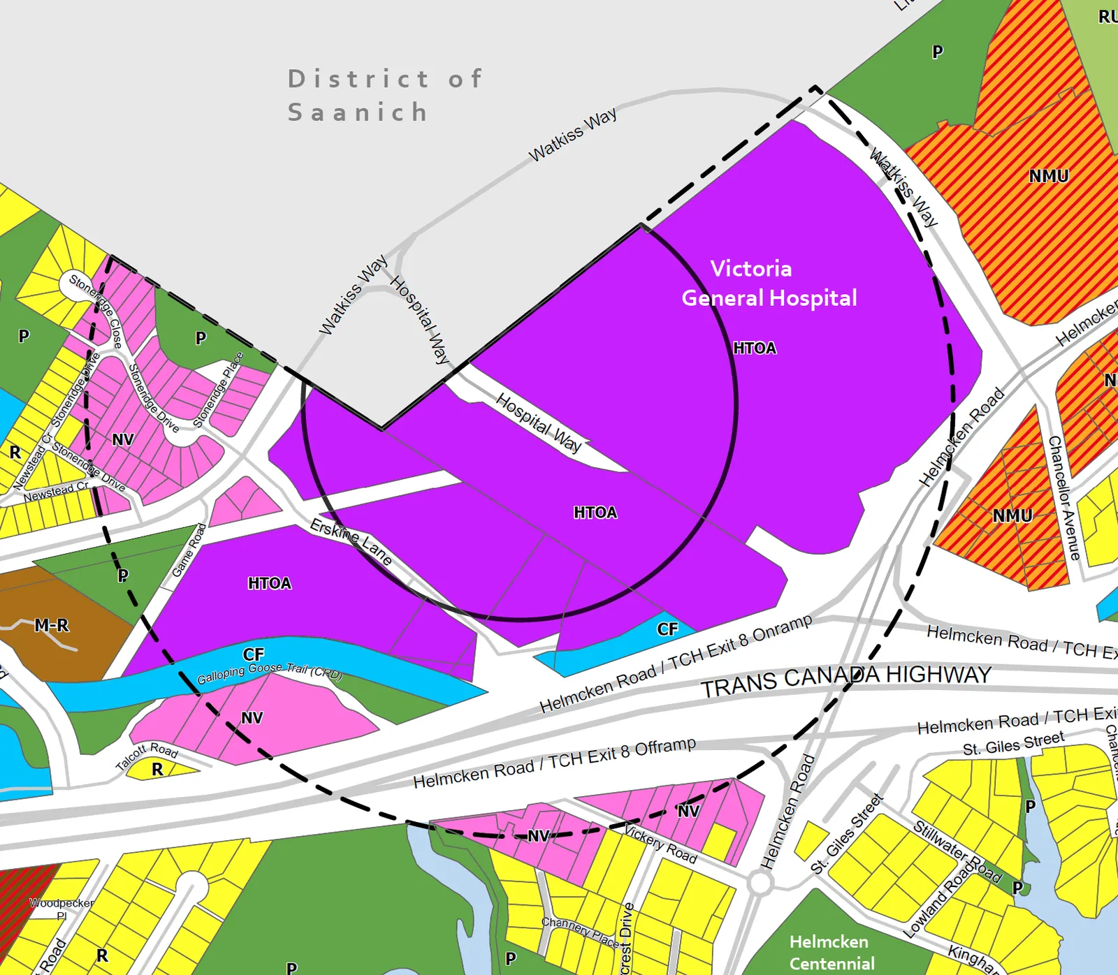
September 9, 2025SSMUH allows up to 6 dwelling unitsHTOA allows up to 10 storeys and 3.5 FSR
Official Community Plan Update – Amendment Bylaw No. 1156, 2025
Committee of the Whole – September 9, 2025
Proposed Amendments
- Replace the Residential and Large Lot Residential land use designations with a new Small-Scale Multi-Unit Housing land use designation to allow up to six dwelling units;
- Establish a new Hospital Transit-Oriented Area land use designation in the designated transit-oriented area (TOA) to allow mixed-use, office and apartment buildings up to 10 storeys and 3.5 FSR;
- Establish a new Neighbourhood Village land use designation within the TOA to allow mixed-use, commercial and apartment buildings up to six-storeys and 2.5 FSR;
- Update any relevant policies to ensure consistency with the provincial housing legislation;
- Add a new Housing Needs Requirements sub-section, under Section 3: Housing;
- Add a new policy, LU 4.14 Mixed Commercial Development, to Section 1: Land Use and Urban Design
Revised Project Timeline
| Activity | Timeline |
|---|---|
| Vision Survey | July 18 to September 7 |
| *Staff draft OCP Amendment Bylaw to align OCP with 20-year housing need. | August 2025 |
| OCP Advisory Committee Meeting | August 2025 |
| *Introduce draft OCP amendment bylaw at Committee of the Whole | September 2025 |
| *Public Hearing for OCP Amendment Bylaw | October 2025 |
| Western Gateway Corridor Engagement | October 2025 – November 2025 |
| *Final Adoption of OCP Amendment Bylaw | November 2025 |
| OCP Policy Review | November – December 2025 |
| First Draft OCP | March 2026 |
| Bylaw Readings & Public Hearing | June 2026 |
| OCP Adoption | September 2026 |
*Align the OCP with the anticipated 20-year housing needs calculated in the Town’s Interim Housing Needs Report and amend the land use designations to satisfy the provincial housing legislation (Bills 44 and 47) by the provincially-mandated deadline of December 31, 2025.
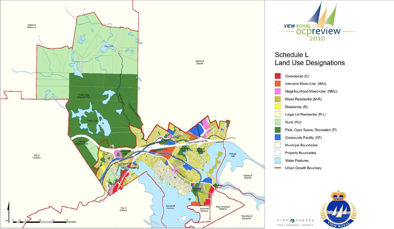
Existing Land Use Designation Map (2011 OCP)
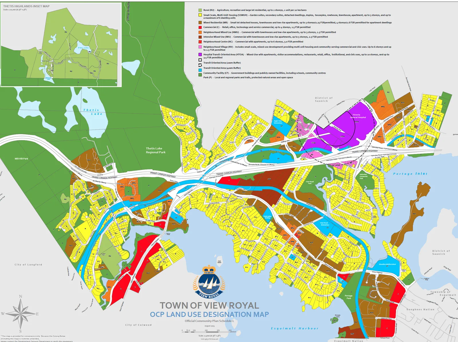
Proposed Land Use Designation Map (Amendment Bylaw No. 1156)
Proposed Land Use Designations
| Existing Land Use Designation | Proposed Land Use Designation |
|---|---|
| Large Lot Residential • Detached Homes • Large Lots and Yards • Up to 2.5 Storeys |
Small-Scale, Multi-Unit Housing (SSMUH) • Uses include detached and attached dwellings, such as detached residential, duplex, secondary suite, garden suite, rowhouse, townhouse, house-plex, and apartments. • Up to three storeys • Up to a maximum of six dwelling units |
| Residential • Predominantly Detached Houses and Townhouses • Up to 2.5 Storeys • Max. FSR .6 permitted for appropriate infill |
Proposed Land Use Designations (Continued)
| Existing Land Use Designation (In HTOA and NV) | Proposed Land Use Designation |
|---|---|
| Community Facility • Government buildings, public facilities, schools Intensive Mixed Use • Commercial with Townhouses and Low-rise apartments, up to 4 storeys and 2.5 FSR Mixed-Residential • Detached House, Townhouse up to 3 storeys and up to 1.25 FSR • Low-Rise Apartment 4 storeys and 1.6 FSR |
Hospital Transit-Oriented Area • Uses include mixed-use with apartments, visitor accommodations, restaurants, retail, office, institutional, (i.e. Hopsital), and civic use (e.g. daycares, libraries, public gathering and amenity spaces). • Up to 10 storeys • Up to 3.5 FSR permitted |
| Mixed Residential • Detached House, Townhouse up to 3 storeys and up to 1.25 FSR • Low-Rise Apartment 4 storeys and 1.6 FSR Residential • Predominantly Detached Houses and Townhouses • Up to 2.5 Storeys • Max. FSR .6 permitted for appropriate infill |
Neighbourhood Village • Uses include small-scale, mixed-use buildings, such as multi-unit housing and community-serving commercial and civic uses (schools, offices, restaurants, retail, small grocery store, and community spaces). • Up to six-storeys • Up to 2.5 FSR permitted |
Recommendation:
THAT the Committee recommend to Council that staff prepare the necessary bylaw amendment to amend the Official Community Plan Bylaw No. 811, 2011 as follows:
- adding a new sub-section, Housing Need Requirement, within Section 3: Housing, to detail the 5- and 20-year period (2021 – 2041) housing need in View Royal;
- revising an existing housing policy, Policy HS1.9 Innovative Approaches, by adding: shelters for persons experiencing homelessness and housing for those at risk of homelessness;
- adding a new policy, Policy HS1.12 Non-Market Units, within Section 3: Housing, to support the development of non-market housing for lower-income populations through collaborative efforts with agencies and governments;
- deleting existing Large Lot Residential (R-L) and Residential (R) land use designations and replacing with a new Small-Scale, Multi-Unit Housing (SSMUH) land use designation defined as follows: uses include detached and attached dwellings, such as detached residential, secondary suite, garden suite, duplex, rowhouse, townhouse, house-plex, and apartments; buildings up to three storeys; and a maximum of six (6) dwelling units;
- adding a new Hospital Transit-Oriented Area (HTOA) land use designation, and amending the existing land use designations of all properties within 200 metres of the identified transit exchange bus stop to the new HTOA land use designation, defined as follows: uses include mixed-use with apartments, visitor accommodations, restaurants, retail, office, institutional (i.e. Hospital), and Civic Use (e.g. daycares, libraries, public gathering and amenity spaces); buildings up to 10 Storeys; and density up to 3.5 Floor Space Ratio (FSR);
- adding a new Neighbourhood Village (NV) land use designation, and amending the existing land use designations of all properties within 201 and 400 metres of the identified transit exchange bus stop to the new NV land use designation, defined as follows: uses include small-scale, mixed-use buildings, such as multiunit housing and community-serving commercial and civic uses (schools, offices, restaurants, retail, small grocery store, and community spaces); buildings up to six storeys; and density up to 2.5 FSR; and
- adding a new policy, LU 4.14 Mixed Commercial Development, to Section 1: Land Use and Urban Design, which states the following: Development of four-storeys or greater should incorporate commercial or public use space.
Page 92–103
Document Images
(1)
Related Documents
(1)Extracted from: 2025 09 09 Committee of the Whole Agenda - Agenda - Pdf