TOWN OF VIEW ROYAL PLANNING & DEVELOPMENT REPORT - REZONING APPLICATION 2021/03 – 10 ERSKINE LANE
A staff report regarding a rezoning application to amend the CD-12 zone for 10 Erskine Lane to allow for increased building height and density.
TOWN OF VIEW ROYAL PLANNING & DEVELOPMENT REPORT
TO: Committee of the Whole
DATE: January 6, 2022
FROM: J. Chow, MCIP, RPP, Senior Planner
MEETING DATE: January 11, 2022
FILE NO.: 3360-20-2021/03
REZONING APPLICATION 2021/03 – 10 ERSKINE LANE
RECOMMENDATION
THAT the January 6, 2022 report from the Senior Planner titled “Rezoning Application 2021/03 – 10 Erskine Lane” be received for information.
CHIEF ADMINISTRATIVE OFFICER’S COMMENTS
I concur with the recommendation.
DIRECTOR OF DEVELOPMENT SERVICES’ COMMENTS
I concur with the recommendation.
DIRECTOR OF ENGINEERING’S COMMENTS
I concur with the recommendation.
PURPOSE OF REPORT
To introduce a rezoning application to amend the CD-12: Comprehensive Development (Erskine Lane) zone to increase the building height, floor space ratio and number of multifamily residential units for the property at 10 Erskine Lane.
BACKGROUND
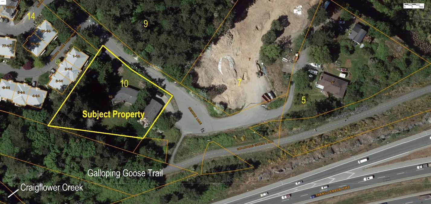
The 2774 m² site is located before the Erskine Lane cul-de-sac as shown in Figure 1. It is bordered by townhouses at 14 Erskine Lane on the west and the Galloping Goose Regional Trail on the south. Trans-Canada Highway is further to the east. There are two detached dwellings on the property, which was rezoned to the site-specific CD-12: Comprehensive Development (Erskine Lane) zone in 2008 to permit apartment use. The property was rezoned under the previous Official Community Plan.
When the property was rezoned in 2008, the following were identified as desirable community amenity contributions:
- Upgrade of the connection to the Galloping Goose Trail to the east of the Land, including a 1.8 metre brushed-finished sidewalk between the land and the trail connection. Trail connection is to extend from the paved road surface to the Galloping Goose trail and is to be 2.0 metres in width and constructed to a standard acceptable to the Director of Engineering.
- Construction of a 1.8 metre brushed-finish concrete sidewalk [from] the frontage of the land and continuing to Watkiss Way.
The rezoning (Land Use Bylaw, 1990, No. 35, Amendment Bylaw No. 708, 2008) and Development Permit 04-08 were approved on the same date on June 3, 2008. The community amenities were secured in a development agreement covenant to be registered prior to development permit issuance. It appears that the Development Permit was never issued, and therefore the covenant was not registered. The development permit approval lapsed after 24 months. Processes at Town Hall have substantially changed since this time to avoid this situation occurring again and covenants are now required in registerable format before adoption of bylaws.
The applicant introduced the current proposal at the November 9, 2021 Committee of the Whole meeting. Committee members discussed community feedback, amenities from prior applications, the in-progress traffic impact assessment, and the unit mix.
PROJECT INFORMATION
The proposal is to amend the CD-12: Comprehensive Development (Erskine Lane) zone to increase the permitted building height, floor space ratio and number of multifamily residential units. The rezoning application addresses zoning issues of land use, density, and standards for lot coverage, percentage of impervious surface, the height and siting of buildings in general. A development concept has been provided but consideration of the specific design would only be formally considered by Council in a development permit application if the rezoning is approved.
The following attachments to this report provide more detailed information on the proposal:
- Subject Property Map
- Subject Property Orthophoto
- Letter from Applicant
- Development Concept Architectural Plans
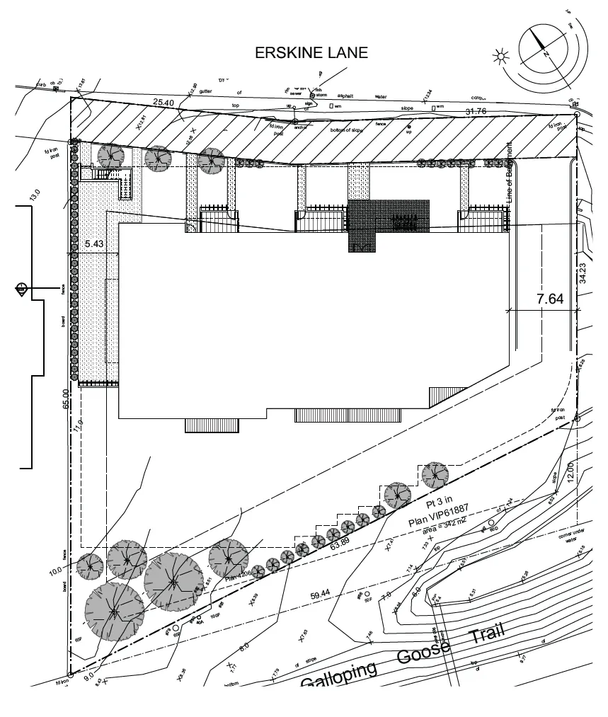
- Civil Drawing
- Traffic Impact Assessment
Development Concept
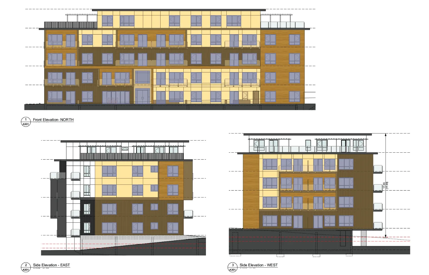
The development concept (Attachment 4) is for a five-storey 43-unit apartment building with the top floor set back as shown in Figures 2-3. A driveway at the east end of the building would provide access to underbuilding and surface parking.
Site Data Summary
| Feature | Value |
|---|---|
| Site Area | 2774 m² |
| Floor Area | 3851.7 m² |
| Floor Space Ratio | tbc |
| Units/Hectare | tbc |
| Building Height | 17.5 m |
| Storeys | 5 |
| Site Coverage | tbc |
| Units | 43 |
| Vehicle Parking | 53* (53 required) |
| Accessible Parking | 1 (1 required) |
| Secure Bicycle Parking | 43 (43 required) |
| *includes accessible parking space |
Unit Mix
| Units by number of bedrooms | Proposed |
|---|---|
| 0-bedroom units | 5 |
| 1-bedroom units | 18 |
| 2-bedrooms units | 20 |
Official Community Plan Context
The site is designated Mixed Residential in the Official Community Plan, which supports multifamily use. It is on the periphery of the Hospital Neighbourhood Centre and would provide additional residential density to support the commercial and employment components of the centre. The proposal is generally in keeping with other OCP policies, including the following:
- The development promotes complete streets through the provision of additional pedestrian and cycling amenities
- The development concept is street oriented with ground level units having a direct connection to the street
- The building form makes efficient use of limited land
- This site is in a location with multimodal transportation opportunities
Proposed Zone
The proposal is to amend the CD-12: Comprehensive Development (Erskine Lane) as follows:
| Regulation | Existing | Proposed |
|---|---|---|
| Principal uses | Residential Apartment | No change |
| Maximum number of residential units | 30 | 43 |
| Floor Space Ratio | 0.85:1 | 1.38* |
| Building Height | 12m | 17.5m |
| Storeys | Three | Five |
| Lot Coverage | 35% | tbc |
| Siting of Buildings and Structures from a lot line | ||
| - Front | 7.5m | No change |
| - Rear | 10m | 5.4m |
| - Side | 7.5m | No change |
| - Side, Flanking | 6m | No change |
| * FSR and Site Area after road dedication will need to be confirmed. |
Design Comment
While the form and character of the development would be formally addressed at the development permit stage, the application provides a level of detail in the development concept to help illustrate the applicant’s intent. Council will formally review the form and character of the project through a development permit application after rezoning.
Staff notes the following:
- A context illustration with the townhouses next door should be provided. While the applicant proposes that a hedge be planted, this may not be adequate to address privacy and overlook issues for the Townhouse units.
- Stepping back the upper floor of the building reduces the massing and would add visual interest to the roofline
- The building and parking are sited to preserve a stand of trees at the south end of the property
Environment
The site is not within any Development Permit Areas for the purpose of environmental protection. There are mature fir trees in the southwest corner and along the west property line. The site has been designed to retain the trees in the southwest corner as a buffer to the Galloping Goose Regional Trail. The trees along the west property line will have to be removed to facilitate the development, but a hedge is proposed to be installed for privacy.
At the southeast corner, the property is separated from the trail by a storm water detention pond that appears to have been formed by the former railbed. Staff recommends native plant restoration in this area. Also, Craigflower Creek is located 50m+ to the south on the other side of the Galloping Goose Trail. The development permit area only applies to land within 30m of the Creek.
A Site Disclosure Statement is not required for this application as the site has been used for residential purposes and there are no indications from the applicant or Town records that the site has a history of Schedule 2 activities (specified commercial or industrial purposes that have the potential to cause contamination).
Community Amenity Contribution
Staff recommends that, subject to agreement between the applicant and Council, a covenant be registered concurrent with fourth reading of the rezoning bylaw to formally secure the community amenity contributions from the 2008 rezoning of this property (to permit 30 apartment units) and that a cash amenity rate of $4000 per unit as per the Community Amenity Contributions Policy apply to the additional 13 units in the current proposal. Alternatively, a covenant could be registered to secure a cash amenity rate of $4000 per unit as per the Community Amenity Contributions Policy for the total 43 units proposed. This alternative is not recommended as many Erskine Lane residents have continued to express a desire for the community amenities considered in the 2008 rezoning.
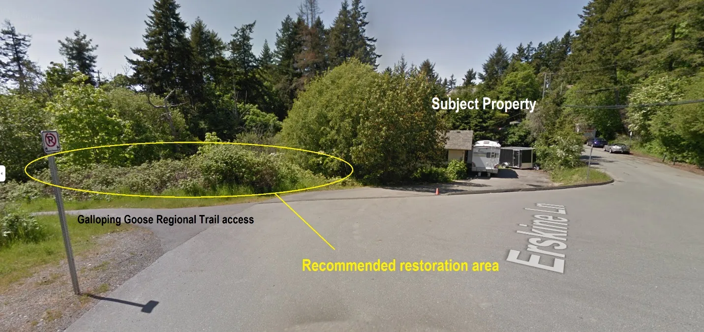
The Community Amenity Contribution Policy target rate is $4,000 per apartment residential unit, to be provided prior to building permit issuance. For the additional 13 apartment residential units, the voluntary contribution would be $52,000 minus any tangible community amenity contributions that Council and the applicant agree to. In this case staff recommends native planting on the boulevard and other steep public land adjacent to the Erskine Lane cul-de-sac (Figure 4) as a potential tangible amenity (further discussion in Servicing section of this report).
Official Community Plan Policy HS1.4 Housing Amenity Contributions supports a housing amenity contribution to the Town, which could be directed to the CRD Regional Housing Trust Fund. The Community Amenity Contributions policy is for 10% of cash amenities received to be transferred to the CRD Regional Housing Trust Fund to supplement the Town’s annual contribution.
BC Transit suggests improving the eastbound bus stop at Watkiss Way / Erskine Lane / Stoneridge Drive intersection by installing a level and accessible platform with a shelter; however, it should be noted a roundabout is proposed for that intersection and the improvements may already be addressed in that project.
Transportation Impact
While the transportation impact assessment (Attachment 7) concludes the proposed development would not significantly impact traffic volumes, the following information is required to fully meet the Town’s Transportation Impact Assessment guidelines:
- Commentary on vehicle and bicycle parking
- Brief review of Transportation Demand Management measures
This site has excellent proximity to the Galloping Goose Regional Trail and there may be some TDM measures that can reduce demand for automobile use.
BC Transit supports the application as it would increase density along the Local Transit Network (LTN) transit corridor, helping to increase and sustain transit ridership for Route 22 Vic General/Hillside Centre and Route 39 Westhills/Interurban/Royal Oak/UVic. The LTN service provides connections to local neighborhoods and local destinations as well as to Rapid and Frequent Transit Networks. This service is vital for the use of residents to get to work, school, or local shopping centers.
The Ministry of Transportation and Infrastructure is also reviewing the Traffic Impact Assessment. Ministry approval is required prior to final reading of the rezoning bylaw because the site is within 800m of an intersection of a controlled access highway.
Site Servicing
The requirements of Subdivision and Development Servicing Bylaw No. 985, 2017 include provision of sidewalks along the site frontages, no net increase in post-development site runoff, and that storm water entering the Town’s drainage system will meet the requirements of Storm Water Regulation Bylaw No. 902, 2015.
The Engineering Department acknowledges the servicing concept’s estimate (Attachment 8) that there is sufficient downstream capacity for the expected sewer flow from the proposed development. Stormwater management will be provided onsite, to be detailed in the development permit.
The additional stormwater drainage loading due to the proposed rezoning is not part of the Town’s Master Drainage Plan and DCC program; however, a 2021 drainage analysis undertaken by Colquitz Engineering revealed that the downstream system has sufficient capacity for proposed development under the current OCP land use designation and this current rezoning application. Consequently, no downstream upgrades to the municipal drainage system are required for this rezoning proposal.
The boulevard and other public land along the Erskine Lane cul-de-sac include steep terrain leading to a storm water detention pond abutting the railway bed now used for the Galloping Goose Regional Trail. While the Town’s landscape standard for boulevards is grass and trees, in this the context staff recommends the complete removal of invasive species and as a community amenity restoring the lands with native vegetation as a more natural alternative. Armoring the overland drainage course to protect against erosion would be a standard servicing requirement.
Road dedication of approximately 4.8m in depth along the north edge of the property is required because the width of the Erskine Lane road allowance is substandard. Road dedication was also required for recent rezonings across the street at 9 Erskine Lane and to a smaller extent at 7 Erskine Lane. It is recommended that a covenant be registered concurrent with the rezoning to ensure that the dedication is provided prior to building permit issuance.
NEXT STEPS
The following items and any other issues identified by the Committee should be addressed for the application to move forward:
- Clarification of site area and floor space ratio after road dedication
- Agreement with the applicant on community amenity contributions
- Confirm if Watkiss Way bus stop improvements are part of the Watkiss Way/Erskine Lane/Stoneridge Drive roundabout as a potential tangible community amenity
- Further Traffic Impact Assessment information on a. Vehicle parking b. Bicycle parking c. Opportunities for Transportation Demand Management
- A context illustration with the townhouses next door should be provided
RECOMMENDATION
THAT the January 6, 2022 report from the Senior Planner titled “Rezoning Application 2021/03 – 10 Erskine Lane” be received for information.
ATTACHMENTS:
- Subject Property Map
- Subject Property Orthophoto
- Letter from Applicant – Wiser Projects, October 6, 2021 (4 pages)
- Development Concept Architectural Plans – Parsi Development (11 pages)
- Civil Drawings – Westbrook Consulting, October 1, 2021
- Traffic Impact Assessment – Watt Consulting, November 23, 2021 (35 pages)
Document Images
(3)