Council Report - Official Community Plan Bylaw No. 1060 and Zoning Bylaw No. 1061 - 298 Island Highway
A staff report detailing the proposed OCP amendment and rezoning for 298 Island Highway to permit a mixed-use development.
TOWN OF VIEW ROYAL COUNCIL REPORT
TO: Council FROM: J. Chow, MCIP RPP, Senior Planner DATE: October 29, 2020 MEETING DATE: November 3, 2020 FILE NO.: 3440-20-2020/01, 3360-20-2020/04
OFFICIAL COMMUNITY PLAN BYLAW NO. 811, 2011 AMENDMENT BYLAW NO. 1060, 2020 AND ZONING BYLAW NO. 900, 2014, AMENDMENT BYLAW NO. BYLAW NO. 1061, 2020 – 298 ISLAND HIGHWAY
RECOMMENDATION
THAT, coincident with final reading of Zoning Bylaw No. 900, 2014, Amendment Bylaw No. Bylaw No. 1061, 2020, a covenant be registered on the lands at 298 Island Highway for the provision of a community amenity contribution of $3,500 per residential unit prior to issuance of a building permit.
CHIEF ADMINISTRATIVE OFFICER’S COMMENTS
I concur with the recommendation.
DIRECTOR OF DEVELOPMENT SERVICES’ COMMENTS
I concur with the recommendation.
DIRECTOR OF ENGINEERING’S COMMENTS
I concur with the recommendation.
PURPOSE OF REPORT
- To introduce two bylaws to create a new OCP land use designation and a new zone to permit redevelopment of the property at 298 Island Highway for commercial and residential use
- To set a public hearing date for the two bylaws
- To register a covenant for the provision of a cash community amenity contribution coincident with fourth reading of the zoning amendment bylaw
BACKGROUND
The 1853 m² subject property is located at the east corner of the Island Highway / Helmcken Road intersection. A single storey restaurant building with surface parking has occupied the lot since the early 1980s.
PROJECT INFORMATION
The purposes of the proposed bylaws are as follows:
Official Community Plan Bylaw Amendment Bylaw No. 1060 To change the Official Community Plan land use designation for the subject property from Neighbourhood Mixed Use (1.5:1 Floor Space Ratio) to a new Neighbourhood Centre land use designation that would permit commercial and residential use. The difference from the Neighbourhood Mixed Use designation is that Neighbourhood Centre land use designation would support buildings up to six storeys and 3.0:1 Floor Space Ratio.
Zoning Bylaw No. 900, 2014, Amendment Bylaw No. Bylaw No. 1061, 2020 To change the zoning of the subject property from C-1: Community Commercial to a new CD-26: Island Highway/Helmcken Comprehensive Development zone permitting commercial and residential use. The rezoning bylaw addresses zoning issues of land use, density, and standards for lot coverage, percentage of impervious surface, the height and siting of buildings in general.
The permitted Mixed Commercial and Residential Use would permit a building with ground floor commercial use and require that residential uses to be on the upper floors. Commercial use means retail store, wholesale sales, service store, office, or other business use.
The permitted building height of 21m would allow sufficient height for a six storey building. The zone would permit buildings to be located close to the front and flanking lot lines to engage the street but would require the fifth and six storeys to be set back at least 2.0m from those lot lines. This is to avoid rectangular, boxy building forms.
Official Community Plan Amendment Application 2020/01 and Rezoning Application 2020/04 were introduced at the September 8, 2020 Committee of the Whole meeting and discussed at the September 15, 2020 Council meeting. Issues regarding traffic impacts, servicing, and public consultation have been addressed and are discussed in the corresponding sections of this report.
The Director of the Provincial Land Remediation Section (formerly Contaminated Sites Branch) provided a letter dated September 15, 2020 allowing the Town to move forward with the zoning application pursuant to s.557(2)(b) of the Local Government Act and not require a site investigation for the zoning application. In accordance with section 7(1) of the Contaminated Sites Regulation, the Director will require a preliminary site investigation following completion of the rezoning.
Development Concept
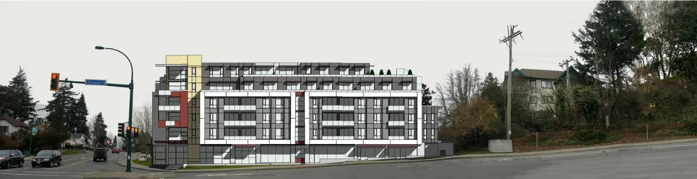
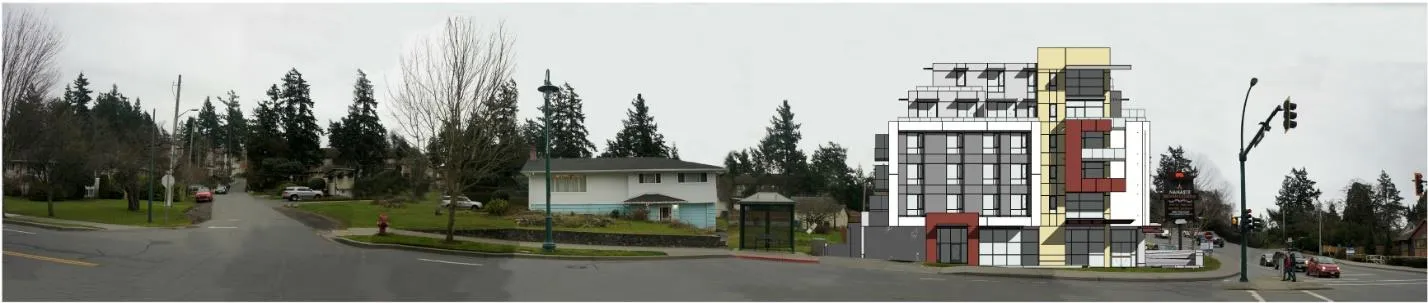
The development concept has not changed since it was introduced at the September 8, 2020 Committee of the Whole meeting, aside from an updated transportation impact assessment. The proposal (Attachments 5-7) is for a six-storey building with the upper two storeys set back as shown in Figures 1-3. The ground floor would be 560m² commercial use with 54 apartment units on the five upper floors. Two levels of underground parking are proposed.
The following attachments to this report provide more information on the proposal:
- Subject Property Map
- Subject Property Orthophoto
- Letter from Applicant
- Open House letters
- Design Rationale
- Architectural Drawings
- Landscape Plan
- Traffic Impact Assessment updated
- Water, Storm and Sanitary Review
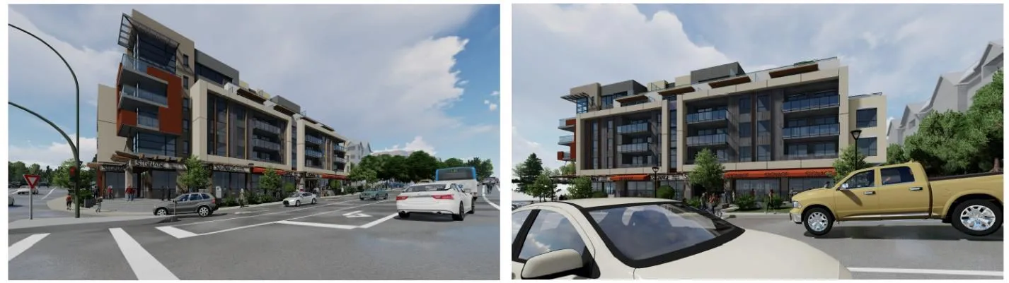
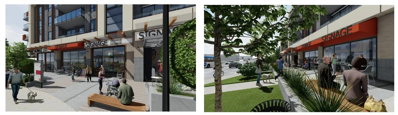
The average depth of the boulevard along Island Highway is over 6m, which would allow the creation of a pedestrian plaza as shown in Figures 4 and 5.
There are two small trees on the property and bushes along shared property lines. The landscape plan (Attachment 7) proposes more trees to screen adjacent Eltham Road properties.
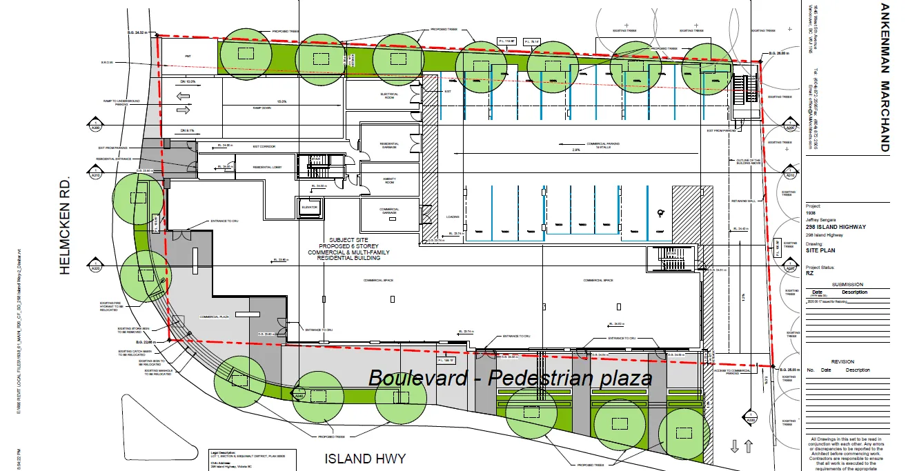
Site Data Summary
| Required (New CD-26 Zone) | Proposed | |
|---|---|---|
| Lot Size | 1500m² | 1853m² |
| Floor Area | - | 5559 m² |
| Floor Space Ratio | 3.0:1 | 3.0:1 |
| Units/Hectare | 292 | |
| Building Height | 21.0m | 20.3m |
| Storeys | 6 | 6 |
| Site Coverage | 80% | 75% |
| Units Proposed | 54 | |
| Vehicle Parking | 102 + 1 loading | 102 + 1 loading |
| Secure Bicycle Parking | 56 | 62 |
Unit Mix
The proposed residential unit mix is as follows:
- 16 one-bedroom units
- 37 two-bedroom units
- 1 three-bedroom unit
Building Height
The building is proposed to be 20.3m and six storeys as measured from the base of the building. The final heights from (calculated) average grade would be finalized at time of Development Permit.
ANALYSIS AND DISCUSSION
Official Community Plan and Land Use Context
The subject property is within the Helmcken-Harbour Community Corridor which separates the Helmcken and Harbour Neighbourhoods. The proposal is consistent with OCP policy LU9.1 (Attachment 10) for the corridor as follows:
- Mixed-use intensification and public space improvement would be concentrated at the Helmcken Intersection.
- The applicant’s concept for a neighbourhood grocery/deli is consistent with the policy that commercial uses should be neighbourhood-serving and limited to properties located near the Helmcken Intersection.
- The plaza would provide extra space for pedestrian safety and support connections across Island Highway and Helmcken Road.
- The proposal would provide a high-quality built environment. The building and pedestrian plaza would become a landmark for this neighbourhood centre.
- Strong and safe connections would be provided to surrounding residential areas, the waterfront, Helmcken Road, View Royal Elementary School and the planned Town Centre.
- Higher residential densities fronting the Island Highway are supported.
- The proposed commercial use would complement and not compete with the future Town Centre and would not inhibit eventual development of the Town Centre desired for the Fort Victoria site.
The policy also states consideration should be made on whether the mixed-use intensity would be appropriate for the corridor’s lots sizes and adjacent residential areas. The proposal may seem dense in terms of residential units per hectare as shown in following table, but in comparison to the other two similar sized recent development sites with 37 units, this proposal translates into an additional 17 units plus the commercial space.
| Development | Address | Units | Lot Area | Units per hectare |
|---|---|---|---|---|
| Current proposal | 298 Island Highway | 54 | 0.1853 ha | 291.4 |
| Lions Cove | 288/290 Island Highway | 66 | 0.8275 ha | 80.0 |
| Maija London | 280 Island Highway | 37 | 0.1677 ha | 220.6 |
| <DP approved, not built> | 242-244 Island Highway | 37 | 0.1860 Ha | 198.9 |
The current land use designation is Neighbourhood Mixed Use, which supports commercial uses with townhouses and apartments up to four storeys with a maximum Floor Space Ratio of 1.5:1. The proposed new Comprehensive Development Area land use designation and new CD-26: Island Highway/Helmcken Comprehensive Development zone would accommodate the development concept with a maximum FSR of 3.0:1 and sufficient building height for six storeys.
The site has been developed and substantially altered for decades and there are no sensitive ecosystems on the property.
Design comment
While the form and character of the development would be addressed at the development permit stage, the application provides a level of detail in the development concept that illustrates their intent. Council will formally review the form and character of the project when considering the Development Permit.
Stepping back the upper two floors of the building will reduce massing and provide a human scale at the street level. The terraced and articulated facade is a complementary interface to the adjacent Lions Cove Apartment and the taller building at a lower starting grade will provide a consistent skyline. A line of trees is proposed to provide some screening for adjacent residential properties on Eltham Road that have Neighbourhood Mixed Use OCP land use designations and are zoned commercial. The proposed public plaza in and along the Island Highway frontage would create a vibrant pedestrian-oriented street realm.
Transportation Impact
The Engineering Department reviewed the updated Traffic Impact Assessment (Attachment 8) with comments (Attachment 12) as follows:
- The proposed development is forecasted to add approximately 3% impact to the volume of automobile traffic moving through the Island Highway / Helmcken Road intersection. The assessment suggests long term (>10 years) lane changes to the Island Highway at the Helmcken Road intersection as shown in Figure 6. Staff does not support this concept because:
- Although more vehicles would move through the intersection on each signal cycle, it would not improve the traffic volume through other intersections of the Island Highway.
- It does not reflect the current Town philosophy regarding commuter through-traffic.
- It would not conform to the Town’s intended cross section for Island Highway.
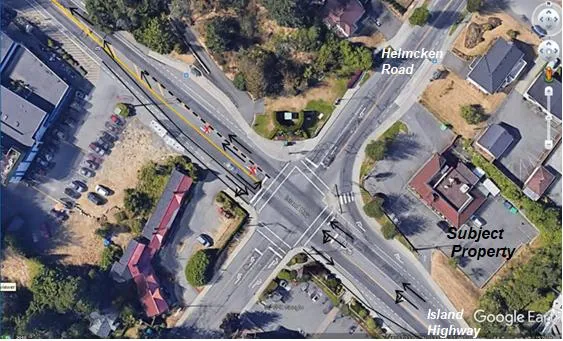
There are no left turns in/out on Island Highway and Helmcken.
- On Helmcken this can be achieved by installing a small concrete median with a few knock down posts for delineation.
- On Island Highway it will be more problematic depending on the frontage design works and how they are achieved especially if the Island Highway work is sequential on the north and south side of island Highway.
For Transportation Demand Management, staff recommends that bicycle parking be located at the ground level to support alternative transportation (instead of on both levels of underground parking) and that a bike repair station be incorporated in the bike room to further encourage mode shift as the close proximity to the E&N rail trail is ideal. This can be explored further at the development permit stage.
The study examined the Town’s 2017 traffic counts and conducted another count in June 2020. It should be noted the more recent counts may be atypical due to influences from summer, the COVID-19 pandemic, and the construction of the Trans Canada Highway / McKenzie interchange.
There is a discrepancy between Section 5.1 of the Transportation Impact Assessment (Attachment 8) and architect's allocations for commercial parking, but the overall number of spaces meets Zoning Bylaw requirements and will be clarified at the DP stage.
BC Transit indicates that the proposed land uses are consistent with the Frequent Transit Network (FTN) corridor and supports continued redevelopment on Island Highway because it would grow ridership and in turn, be supported with increased service levels.
There is a two-seat transit shelter (Stop ID 101051) for the 14 Vic General route just north of the Helmcken Road site frontage. BC Transit supports an upgrade to a T-3 type (i.e. moderate volume) shelter as the development can be expected to produce an increase in ridership at this stop.
Site Servicing
Subdivision and Development Servicing Bylaw No. 985, 2017 includes servicing requirements such for offsite works and services such as roads, sanitary sewer and storm drainage. Servicing reviews at the rezoning stage are to determine whether there is adequate offsite infrastructure capacity.
The Engineering Department has reviewed the Servicing Concept (Attachment 9) and is satisfied that that the additional sewer demand would be within the Town’s allocation for discharge to the regional sanitary sewer system and that there is adequate capacity in the Helmcken Bay sanitary sewer lift station to accommodate the proposed development. A more detailed servicing concept will be required at the development permit stage if the bylaws are approved.
Fire Protection
The Protective Services Department has no issues or concerns about providing fire service for the land uses in the proposed rezoning.
Community Amenity Contribution
The Community Amenity Contribution Policy target rate is $3,500 per multifamily residential unit. For this proposal, the contribution would be $189,000 based on 54 units and would be provided prior to building permit issuance. It is recommended that the community amenity contribution provision rate be secured in a covenant.
OCP Policy HS1.4 Housing Amenity Contributions also supports a housing amenity contribution to the Town, which could be directed to the CRD Regional Housing Trust Fund. A portion of the cash community amenity contributions could be used for this purpose.
Public Consultation
The Local Government Act has requirements for early and ongoing consultation of Official Community Plan amendments. The application was referred to the relevant agencies as part of the application review process with no major concerns noted. The applicant has notified the neighbourhood as follows:
- April 2020 – door knocking campaign for residences within three blocks of the site
- May 2020 - open house for 288/290 Island Highway (Lions Cove). Comment letters are provided in Attachment 4.
- October 2020 – over 500 flyers distributed to properties within the 400m public hearing notification radius, with website/email address setup to receive comments. Three questions have been received by the applicant to date (see Attachment 11).
RECOMMENDATION
THAT, coincident with final reading of Zoning Bylaw No. 900, 2014, Amendment Bylaw No. Bylaw No. 1061, 2020, a covenant be registered on the lands at 298 Island Highway for the provision of a community amenity contribution of $3,500 per residential unit prior to issuance of a building permit.
SUBMITTED BY: J. Chow MCIP RPP, Community Planner
REVIEWED BY: L. Chase MCIP RPP, Director of Development Services
ATTACHMENTS:
- Subject Property Map
- Subject Property Orthophoto
- Letter from Applicant, May 27, 2020 (13 pages)
- Open House - Letters (22 pages)
- Design Rationale - Ankenman Marchand Architects, (3 pages)
- Architectural Drawings – Ankenman Marchand Architects, June 17-Aug. 31, 2020 (35 pages)
- Landscape Plan - Lombard North Group, June 12, 2020
- Traffic Impact Assessment – Addoz Engineering Inc. – October 8, 2020 (47 pages)
- Water, Storm and Sanitary Review - JE Anderson, August 27, 2020 (20 pages)
- OCP excerpt: Policy LU9.1 Helmcken-Harbour Community Corridor
- October 2020 public notification – communications with application (2 pages)
- Bunt & Associates Review of Addoz Traffic Impact Assessment (5 pages)
Document Images
(3)